
Great Platte River Road facts for kids

The Great Platte River Road was a very important travel path in the 1800s. It followed the Platte River through what is now Nebraska and Wyoming. Many famous trails shared this route. These included the Oregon Trail, the Mormon Trail, and the California Trail. Even the Pony Express used parts of it!
This road stretched for almost 800 miles (1,300 km). It went from Fort Kearny to Fort Laramie. People used it mostly between 1841 and 1866. Think of it like an old-time "superhighway" for pioneers. It was a main route for America's move westward.
Contents
Where Did the Great Platte River Road Go?

The Great Platte River Road started in different towns along the Missouri River. These towns included Omaha, Council Bluffs, and Kansas City. All these separate paths eventually met near Fort Kearny in the middle of Nebraska.
Travelers from Omaha and Council Bluffs usually stayed on the north side of the Platte River. Those from Kansas City often used the south side. At some point, everyone had to cross to the north side. This crossing was often very dangerous.
The Platte River splits into two branches in western Nebraska. Some trails, like the Oregon and California Trails, followed the North Platte River. Other trails, such as the Overland Trail, turned southwest to follow the South Platte River.
A Look Back: History of the Road
Early Explorers and Growing Popularity
Robert Stuart was an early explorer. He explored this route in the 1810s. As the United States grew, more and more people wanted to move west. Many settlers followed the paths of earlier explorers. They often followed the Platte River because it was easy to navigate. It also provided a good source of water.
The Platte River corridor became the main way to travel across the country. It was so straightforward that many different pioneer trails used it at the same time. All pioneers on the Oregon or California Trails used the Great Platte River Road for hundreds of miles.
Challenges on the Trail
Many people believed the north side of the river was healthier. So, most Latter-day Saints (Mormons) stayed on that side. This also helped them avoid problems with people from Missouri or Illinois.
In some years, like 1849, 1850, and 1852, so many people traveled that there was no grass left for animals to eat. This lack of food, along with the risk of disease, made the journey very risky. About 250,000 travelers used the Great Platte River Road during its busiest years. These were from 1841 to 1866. The Pony Express also used this road. It later became important for carrying goods and for military travel.
Travelers also faced dangers from conflicts with Native American tribes. After some attacks in 1864, fighting increased along the South Platte. There were raids on stations and wagons. After a difficult event called the Sand Creek massacre, the town of Julesburg, Colorado was attacked in 1865.
The End of an Era and New Roads
Traditional travel on the road slowed down after 1869. That's when the First Transcontinental Railroad was finished. This railroad followed much of the same route through Nebraska.
Even today, this route is still important for travel. The Lincoln Highway, built in 1913, followed it. Later, Interstate 80 was built along the same path.
Important Places Along the Route
Nebraska Landmarks
- Fort Kearny — This fort was built in June 1848. It was named after Stephen Watts Kearny. Another fort with the same name was built earlier but then left. The land for this fort was bought from the Pawnee Indians for $2,000 worth of goods.
- Confluence Point — On May 11, 1847, a special device called a "roadometer" was used here. It was attached to a wagon to measure distances. The measurements were very accurate. They were used to create a famous guide for pioneer travelers.
- O'Fallon's Bluff — This was a very tricky part of the road. The South Platte River flowed right against a steep cliff. This meant travelers had to use a narrow path over the bluffs. Deep sand could trap wagon wheels. There were also threats of attacks. Many pioneer journals mention this difficult spot. Later, a trading post and a stage station were built here.
- Ash Hollow — Many pioneers wrote about how beautiful Ash Hollow was. But thousands of travelers soon changed its look. Sioux Indians were often in this area. A battle between U.S. troops and the Sioux happened here in September 1855. Many people who died from cholera during the gold rush years are buried here.
- Chimney Rock — This is one of the most famous landmarks on the Mormon Trail. Pioneers often wrote in their diaries that it looked closer than it was. Many drew pictures of it or carved their names into it.
- Scotts Bluff — This bluff is named after Hiram Scott. He was a fur trapper who became sick and was left behind by his friends. Many pioneer journals mention his death. The grave of Rebecca Winters, a Mormon mother who died from cholera in 1852, is also near here.
Wyoming Landmarks
- Fort Laramie — This old trading post and military fort was a place for pioneers to rest. They could also buy more supplies here. In 1856, the Willie Handcart Company could not get supplies at Fort Laramie. This led to big problems for them later when they ran out of food in a blizzard.
- Upper Platte/Mormon Ferry — The last crossing of the Platte River happened near modern Casper. For several years, the Latter-day Saints ran a ferry here. They earned money from pioneers heading to Oregon and California. The ferry stopped in 1853 when a toll bridge was built. In 1856, the Martin Handcart Company crossed the freezing river here in October. Many people died from the cold.
- Red Butte — This was a very sad place on the Mormon Trail. After crossing the Platte River, the Martin Handcart Company camped near Red Butte. Heavy snow fell for three days, and many pioneers died. The company stayed there for nine days, and 56 people died from cold or sickness. Finally, rescuers arrived and urged them to keep moving.
- Sweetwater River — From the last Platte River crossing, the trail goes southwest to Independence Rock. Then it follows the Sweetwater River to South Pass. To make the trip shorter, the trail crosses the river nine times.
Towns Along the Road

Ranches and towns grew up along the Great Platte River Road. These places gave outfitters (people who sold supplies) places to sell their goods. They also gave pioneers places to rest. Here are some of the settlements that appeared from east to west:
- Hook
- Fort Kearny
- Dobytown
- Platte
- 17 Mile
- Hopeful
- Craig
- Blondeau
- Thomas
- Freeman
- Mullaley
- Pinniston and Miller
- Midway
- Gilman
- Clark
- Machete
- McDonald
- Post Cottonwood
- Box Elder
- Cold Springs
- Bishop
- Fremont's Springs
- O'Fallon
- Williams
- Moore
- Alkali
- Sandhill
- Diamond Springs
- Beauvais
- Bueller
- Julesburg
- Camp Rankin
Other Routes That Connected
Many other trails, railroads, and highways used or connected to the Great Platte River Road. These include:
- Trapper's Trail
- Oregon Trail
- California Trail
- Mormon Trail
- Pony Express
- Overland Trail
- First Transcontinental Railroad
- Lincoln Highway
- U.S. Route 30
- Interstate 80
Images for kids
-
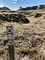
A photo of the former overland trails, with historic trails marker, through Mitchell Pass at Scotts Bluff National Monument.
-
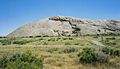
Independence Rock, a site along the Mormon Trail


