Granger, Wyoming facts for kids
Quick facts for kids
Granger, Wyoming
|
|
|---|---|

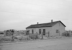
Granger stage station, built in 1856, on Old U.S. Route 30
|
|

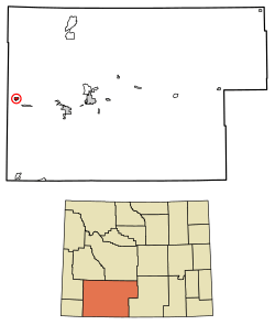
Location of Granger in Sweetwater County, Wyoming.
|
|
| Country | United States |
| State | Wyoming |
| County | Sweetwater |
| Area | |
| • Total | 2.59 sq mi (6.70 km2) |
| • Land | 2.59 sq mi (6.70 km2) |
| • Water | 0.00 sq mi (0.00 km2) |
| Elevation | 6,273 ft (1,912 m) |
| Population
(2010)
|
|
| • Total | 139 |
| • Estimate
(2019)
|
128 |
| • Density | 49.46/sq mi (19.10/km2) |
| Time zone | UTC-7 (Mountain (MST)) |
| • Summer (DST) | UTC-6 (MDT) |
| ZIP code |
82934
|
| Area code(s) | 307 |
| FIPS code | 56-32870 |
| GNIS feature ID | 1589030 |
Granger is a small town in Sweetwater County, Wyoming, United States. It is located near the western edge of the county, where the Blacks Fork and Hams Fork rivers meet. The area around Granger is mostly flat and dry.
In 2010, the town had a population of 139 people. Even though it's a small place, Granger has a very interesting history because of its location.
Contents
A Look Back: Granger's Early History (1834–1868)
Granger's location was very important for travelers and traders in the past. It sits where two famous trails crossed: the Oregon Trail and the Overland Stage Trail. Because of this, it became a key stop for stage coaches.
A stone and adobe building was constructed in 1856 to serve as a stage station. This station was even used by the famous writer Mark Twain when he traveled through the area. It is still standing today! From 1861 to 1862, the Pony Express also used this station as a stop for its riders. Later, in 1868, a railroad line came through, and that's when the area officially became known as Granger.
Before the trails and railroads, the Granger area was important to mountain men. These were trappers who explored the American West in the early 1800s. In 1834, they held their yearly gathering, called a rendezvous, near where the Hams Fork and Blacks Fork rivers meet.
During the rendezvous, American Indians and trappers would trade furs for supplies. It was a time for everyone to share stories from the past year and have fun. Companies like the American Fur Company would set up camps along the river to trade goods.
Where is Granger? Geography
Granger is located at 41°35′39″N 109°58′0″W / 41.59417°N 109.96667°W.
The United States Census Bureau says that the town covers a total area of about 6.70 square kilometers (2.59 square miles). All of this area is land, with no water.
Who Lives in Granger? Population Facts
| Historical population | |||
|---|---|---|---|
| Census | Pop. | %± | |
| 1920 | 136 | — | |
| 1930 | 135 | −0.7% | |
| 1940 | 163 | 20.7% | |
| 1950 | 122 | −25.2% | |
| 1960 | 159 | 30.3% | |
| 1970 | 137 | −13.8% | |
| 1980 | 177 | 29.2% | |
| 1990 | 126 | −28.8% | |
| 2000 | 146 | 15.9% | |
| 2010 | 139 | −4.8% | |
| 2019 (est.) | 128 | −7.9% | |
| U.S. Decennial Census | |||
Population in 2010
According to the census from 2010, there were 139 people living in Granger. These people lived in 57 households, and 38 of those were families.
The average number of people in each household was about 2.44. The average family size was about 2.82 people.
About 25.2% of the people in Granger were under 18 years old. About 7.2% were 65 years old or older. The average age in the town was 39.5 years.
Learning in Granger: Education
Children in Granger attend public schools that are part of the Sweetwater County School District #2.
The town also has a public library. It is a part of the Sweetwater County Library System, which means residents can use its resources.
See also
 In Spanish: Granger (Wyoming) para niños
 | Misty Copeland |
 | Raven Wilkinson |
 | Debra Austin |
 | Aesha Ash |


