Fremont, Utah facts for kids
Quick facts for kids
Fremont, Utah
|
|
|---|---|

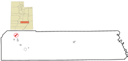
Location in Wayne County and the state of Utah.
|
|
| Country | United States |
| State | Utah |
| County | Wayne |
| Settled | 1876 |
| Founded by | William Wilson Morrell |
| Named for | Fremont River |
| Area | |
| • Total | 1.7 sq mi (4.5 km2) |
| • Land | 1.7 sq mi (4.5 km2) |
| • Water | 0 sq mi (0.0 km2) |
| Elevation | 7,218 ft (2,200 m) |
| Population
(2010)
|
|
| • Total | 145 |
| • Density | 83.5/sq mi (32.2/km2) |
| Time zone | UTC-7 (Mountain (MST)) |
| • Summer (DST) | UTC-6 (MDT) |
| ZIP code |
84747
|
| Area code(s) | 435 |
| GNIS feature ID | 2629949 |
Fremont is a small community in Wayne County, Utah, United States. It is known as a census-designated place, which means it's a special area defined by the government for gathering population information. Fremont is located in the northwestern part of Wayne County.
You can find Fremont along State Route 72. It is just northeast of Loa, which is the main town and county seat of Wayne County. To the north of Fremont is the beautiful Fishlake National Forest. Fremont sits at an elevation of about 7,218 feet (2,200 meters) above sea level. In 2010, 145 people lived there.
Early History of Fremont
The first people to settle permanently in Fremont were the family of William Wilson Morrell. They arrived in 1876. The community was named after the Fremont River, which flows nearby.
Population and People
According to the 2010 census, 145 people lived in Fremont. There were 96 homes in the area. Most of the people living there, about 97.9%, were White. A small number were Asian (0.7%) or from two or more racial backgrounds (1.4%). About 2.1% of the population identified as Hispanic or Latino.
See also
 In Spanish: Fremont (Utah) para niños
 | Precious Adams |
 | Lauren Anderson |
 | Janet Collins |

