Boulder, Utah facts for kids
Quick facts for kids
Boulder, Utah
|
|
|---|---|
|
Town
|
|

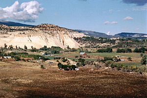
From the Hogsback of Highway 12, the ranching and farming community of Boulder nestles amidst rugged terrain.
|
|

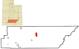
Location in Garfield County and state of Utah.
|
|
| Country | United States |
| State | Utah |
| County | Garfield |
| Settled | c. 1890 |
| Named for | Boulder Mountain |
| Area | |
| • Total | 20.93 sq mi (54.22 km2) |
| • Land | 20.93 sq mi (54.22 km2) |
| • Water | 0.00 sq mi (0.00 km2) |
| Elevation | 6,700 ft (2,000 m) |
| Population
(2020)
|
|
| • Total | 227 |
| • Estimate
(2019)
|
241 |
| • Density | 11.51/sq mi (4.44/km2) |
| Time zone | UTC-7 (MST) |
| • Summer (DST) | UTC-6 (MDT) |
| ZIP code |
84716
|
| Area code(s) | 435 |
| FIPS code | 49-07470 |
| GNIS feature ID | 1437510 |
Boulder is a small town located in Garfield County, Utah, in the United States. It's about 27 miles (44 km) northeast of Escalante. You can find it along Utah Scenic Byway 12, where it meets the Burr Trail. In 2020, the town had a population of 227 people.
Boulder was quite cut off from other places until the Civilian Conservation Corps built a road from Escalante. This road made it much easier to reach the town. Boulder didn't even get electricity until 1947! The town is also where the Burr Trail begins. This road goes east through amazing red rock landscapes and leads to the Waterpocket Fold in Capitol Reef National Park. Boulder is also home to the Anasazi Indian State Park.
Contents
Exploring Boulder's Location
Boulder is located near two amazing natural areas: Grand Staircase–Escalante National Monument and Capitol Reef National Park. These parks are known for their stunning landscapes and outdoor adventures.
Land Area and Features
The town of Boulder covers an area of about 20.9 square miles (54.2 km²). All of this land is dry land, meaning there are no large lakes or rivers within the town's boundaries. Boulder is also known for its many cool sandstone formations, including small mountains and slopes.
Fun Trails and Scenic Roads
If you love biking, the American Discovery Trail has a special bicycle route that goes right through Boulder. This trail is a long path that crosses the United States!
Boulder's Climate
Boulder has a semi-arid climate, which means it's generally dry but not a desert. The hottest temperature ever recorded in Boulder was 97°F (36°C) on June 16, 2021. The coldest temperature recorded was -17°F (-27°C) on February 6, 1989.
| Climate data for Boulder, Utah, 1991–2020 normals, extremes 1954–present | |||||||||||||
|---|---|---|---|---|---|---|---|---|---|---|---|---|---|
| Month | Jan | Feb | Mar | Apr | May | Jun | Jul | Aug | Sep | Oct | Nov | Dec | Year |
| Record high °F (°C) | 63 (17) |
69 (21) |
75 (24) |
82 (28) |
89 (32) |
97 (36) |
96 (36) |
95 (35) |
93 (34) |
85 (29) |
71 (22) |
65 (18) |
97 (36) |
| Mean maximum °F (°C) | 50.7 (10.4) |
56.1 (13.4) |
66.9 (19.4) |
73.9 (23.3) |
80.9 (27.2) |
88.7 (31.5) |
91.6 (33.1) |
89.0 (31.7) |
84.9 (29.4) |
75.6 (24.2) |
62.5 (16.9) |
52.3 (11.3) |
92.1 (33.4) |
| Mean daily maximum °F (°C) | 39.5 (4.2) |
43.6 (6.4) |
52.8 (11.6) |
59.7 (15.4) |
68.1 (20.1) |
78.8 (26.0) |
83.6 (28.7) |
81.2 (27.3) |
74.0 (23.3) |
62.4 (16.9) |
49.3 (9.6) |
39.3 (4.1) |
61.0 (16.1) |
| Daily mean °F (°C) | 30.4 (−0.9) |
34.1 (1.2) |
41.7 (5.4) |
47.7 (8.7) |
56.4 (13.6) |
66.6 (19.2) |
72.4 (22.4) |
70.4 (21.3) |
63.0 (17.2) |
51.5 (10.8) |
39.5 (4.2) |
30.2 (−1.0) |
50.3 (10.2) |
| Mean daily minimum °F (°C) | 21.3 (−5.9) |
24.5 (−4.2) |
30.7 (−0.7) |
35.8 (2.1) |
44.6 (7.0) |
54.4 (12.4) |
61.2 (16.2) |
59.6 (15.3) |
52.0 (11.1) |
40.5 (4.7) |
29.6 (−1.3) |
21.1 (−6.1) |
39.6 (4.2) |
| Mean minimum °F (°C) | 5.2 (−14.9) |
9.3 (−12.6) |
15.7 (−9.1) |
21.5 (−5.8) |
29.7 (−1.3) |
38.8 (3.8) |
50.3 (10.2) |
49.8 (9.9) |
36.7 (2.6) |
23.7 (−4.6) |
12.4 (−10.9) |
3.2 (−16.0) |
3.1 (−16.1) |
| Record low °F (°C) | −16 (−27) |
−17 (−27) |
0 (−18) |
8 (−13) |
20 (−7) |
27 (−3) |
32 (0) |
34 (1) |
24 (−4) |
4 (−16) |
−1 (−18) |
−11 (−24) |
−17 (−27) |
| Average precipitation inches (mm) | 1.07 (27) |
1.05 (27) |
0.91 (23) |
0.51 (13) |
0.72 (18) |
0.38 (9.7) |
1.11 (28) |
1.73 (44) |
1.58 (40) |
1.44 (37) |
0.56 (14) |
0.79 (20) |
11.85 (300.7) |
| Average snowfall inches (cm) | 15.7 (40) |
10.8 (27) |
6.7 (17) |
2.3 (5.8) |
0.4 (1.0) |
0.0 (0.0) |
0.0 (0.0) |
0.0 (0.0) |
0.0 (0.0) |
0.5 (1.3) |
3.5 (8.9) |
11.7 (30) |
51.6 (131) |
| Average precipitation days (≥ 0.01 in) | 5.5 | 6.1 | 4.6 | 4.3 | 5.4 | 2.8 | 8.1 | 9.8 | 6.9 | 5.2 | 3.1 | 5.2 | 67.0 |
| Average snowy days (≥ 0.1 in) | 4.0 | 3.9 | 2.2 | 0.8 | 0.2 | 0.0 | 0.0 | 0.0 | 0.0 | 0.2 | 1.2 | 3.8 | 16.3 |
| Source 1: NOAA | |||||||||||||
| Source 2: National Weather Service | |||||||||||||
People of Boulder
| Historical population | |||
|---|---|---|---|
| Census | Pop. | %± | |
| 1900 | 104 | — | |
| 1910 | 91 | −12.5% | |
| 1920 | 177 | 94.5% | |
| 1930 | 192 | 8.5% | |
| 1990 | 126 | — | |
| 2000 | 180 | 42.9% | |
| 2010 | 226 | 25.6% | |
| 2019 (est.) | 241 | 6.6% | |
| U.S. Decennial Census | |||
In 2000, there were 180 people living in Boulder. These people lived in 65 households, and 41 of those were families. The town had about 8.6 people per square mile. Most of the people living in Boulder were White. A small number were Asian, and some identified with two or more races. About 1% of the population was Hispanic or Latino.
Many households (33.8%) had children under 18 living with them. More than half (52.3%) were married couples. The average household had about 2.77 people, and the average family had about 3.54 people.
The population included people of all ages. About 30% were under 18 years old, and 11.1% were 65 or older. The average age in Boulder was 34 years.
See also
 In Spanish: Boulder (Utah) para niños
 | Jessica Watkins |
 | Robert Henry Lawrence Jr. |
 | Mae Jemison |
 | Sian Proctor |
 | Guion Bluford |


