Escalante, Utah facts for kids
Quick facts for kids
Escalante, Utah
|
|
|---|---|
|
City
|
|

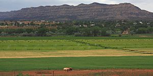
Escalante and the Straight Cliffs from the north
|
|

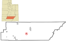
Location in Garfield County and state of Utah
|
|
| Country | United States |
| State | Utah |
| County | Garfield |
| Settled | 1875 |
| Named for | Silvestre Vélez de Escalante |
| Area | |
| • Total | 3.30 sq mi (8.55 km2) |
| • Land | 3.30 sq mi (8.55 km2) |
| • Water | 0.00 sq mi (0.00 km2) |
| Elevation | 5,820 ft (1,770 m) |
| Population
(2020)
|
|
| • Total | 786 |
| • Estimate
(2019)
|
798 |
| • Density | 241.74/sq mi (93.33/km2) |
| Time zone | UTC-7 (Mountain (MST)) |
| • Summer (DST) | UTC-6 (MDT) |
| ZIP code |
84726
|
| Area code(s) | 435 |
| FIPS code | 49-23750 |
| GNIS feature ID | 2410452 |
| State Routes | |
Escalante is a small city in central Garfield County, Utah, United States. It is located along Utah Scenic Byway 12, a famous road in the southern part of the state. In 2020, about 786 people lived in Escalante.
The city is named after Silvestre Vélez de Escalante. He was a Franciscan missionary and part of the first European group to explore what is now southern Utah.
Escalante is surrounded by amazing natural areas. The Escalante Petrified Forest State Park is just west of the city. Large parts of the Grand Staircase–Escalante National Monument (GSENM) are right next to the city. The Hole-in-the-Rock Road starts a short distance east of Escalante. This road leads to cool places like the Canyons of the Escalante, the Devils Garden, and the Hole-in-the-Rock.
Contents
History of Escalante
Early Explorers and Naming
In 1776, two explorers, Silvestre Vélez de Escalante and Francisco Atanasio Domínguez, left Santa Fe, New Mexico. They were trying to find a route to missions in California. Their journey, called the Dominguez–Escalante Expedition, went through parts of Colorado, Utah, and Arizona. They did not actually enter the area where Escalante city is today.
Later, in 1866, Captain James Andrus led a group of soldiers through the Escalante area. This was during the Black Hawk Indian War. They found wild potatoes growing in the valley where the city now stands. Because of this, they named it Potato Valley.
Settlers from Panguitch first visited the area in the 1870s. They met members of the John Wesley Powell expedition there. Powell's group suggested naming the settlement Escalante to honor the earlier explorer. This was done even though Escalante himself had not visited the valley.
Settlement and Growth
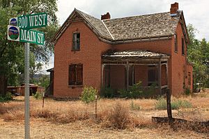
In June 1875, the settlers returned to survey the valley. They marked out areas for farming and city lots. After spending the winter back in Panguitch, they came back. The first home was built in March 1876 by William Alvey. Many early homes were built using local bricks. Some of these brick homes are still standing today.
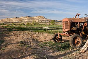
The main jobs in early Escalante were cattle and sheep ranching, dairy farming, logging, and mining. Today, farming and ranching are still important. However, tourism has also become a big part of the local economy.
In the 1930s, the Civilian Conservation Corps (CCC) helped build better roads. These roads led to places like Posey Lake and Boulder.
Population Changes
In the 1940s, many people left Escalante to find work in bigger cities. This caused the population to drop by 33% by the 1950 census. The number of people living in Escalante continued to decrease for the next two decades. It reached a low of 638 people, which was only a few more than in 1880.
However, the population started to grow again. By 1990, it had increased by 25%. It stayed about the same in 2000 and dropped slightly in 2010.
Since the Grand Staircase–Escalante National Monument (GSENM) was created in 1996, Escalante has seen many more tourists. Most visitors come during the spring, summer, and fall. A study in 2004 showed that about 600,000 people visited parts of GSENM. Many of these visitors passed through Escalante.
Population of Escalante
| Historical population | |||
|---|---|---|---|
| Census | Pop. | %± | |
| 1880 | 623 | — | |
| 1890 | 667 | 7.1% | |
| 1900 | 723 | 8.4% | |
| 1910 | 846 | 17.0% | |
| 1920 | 1,032 | 22.0% | |
| 1930 | 1,016 | −1.6% | |
| 1940 | 1,161 | 14.3% | |
| 1950 | 773 | −33.4% | |
| 1960 | 702 | −9.2% | |
| 1970 | 638 | −9.1% | |
| 1980 | 652 | 2.2% | |
| 1990 | 818 | 25.5% | |
| 2000 | 818 | 0.0% | |
| 2010 | 797 | −2.6% | |
| 2019 (est.) | 798 | 0.1% | |
| U.S. Decennial Census | |||
As of the 2010 census, 797 people lived in Escalante. There were 334 households, and 217 of them were families. Most people in Escalante are White. A small number are American Indian, Asian, Black, or other races. About 3.5% of the population is Hispanic or Latino.
The population is spread across different age groups. About 22% of the people are under 18 years old. About 18% are 65 years or older. The average age in Escalante is about 45 years old.
Geography of Escalante

Escalante covers an area of about 2.944 square miles (7.625 km2). It is all land, with no large bodies of water.
The city is surrounded by mountains, cliffs, and sandstone canyons. These are part of the Grand Staircase–Escalante National Monument (GSENM) and the Dixie National Forest.
Escalante is located in a place called Potato Valley. The Escalante River flows from the west, past the north side of the city. To the southeast are the Canyons of the Escalante. South of the city are the Straight Cliffs, which stretch towards Lake Powell. The Kaiparowits Plateau is to the south and southwest. To the west are the Dixie National Forest and the Escalante Mountains. North of the city, you'll find a small part of GSENM, the Box-Death Hollow Wilderness, and the Aquarius Plateau.
Climate in Escalante
Escalante has a cold, dry climate, also known as a semi-arid or steppe climate. On average, it gets about 10.56 inches (268 mm) of rain each year. Most of the rain falls from July to October, with August being the wettest month. June is usually the driest month.
Snow mainly falls from November to April. On average, Escalante gets about 25.5 inches (65 cm) of snow each year.
Temperatures change a lot between day and night. In winter, the difference is about 26 °F (14 °C). In summer, it's about 37 °F (20 °C). July has the warmest average high temperatures, around 92.3 °F (33.5 °C). January has the coldest average low temperatures, around 18.8 °F (-7.3 °C).
The highest temperature ever recorded in Escalante was 106 °F (41 °C) on July 9, 2021. The lowest temperature ever recorded was -22 °F (-30 °C) on January 22, 1937.
| Climate data for Escalante 1991-2020 normals, extremes 1901- | |||||||||||||
|---|---|---|---|---|---|---|---|---|---|---|---|---|---|
| Month | Jan | Feb | Mar | Apr | May | Jun | Jul | Aug | Sep | Oct | Nov | Dec | Year |
| Record high °F (°C) | 68 (20) |
76 (24) |
81 (27) |
88 (31) |
98 (37) |
105 (41) |
106 (41) |
104 (40) |
101 (38) |
92 (33) |
78 (26) |
69 (21) |
106 (41) |
| Mean daily maximum °F (°C) | 43.1 (6.2) |
48.0 (8.9) |
58.0 (14.4) |
65.5 (18.6) |
75.5 (24.2) |
87.1 (30.6) |
92.3 (33.5) |
89.1 (31.7) |
81.3 (27.4) |
68.3 (20.2) |
53.8 (12.1) |
42.9 (6.1) |
67.1 (19.5) |
| Mean daily minimum °F (°C) | 18.8 (−7.3) |
23.3 (−4.8) |
29.3 (−1.5) |
34.8 (1.6) |
41.9 (5.5) |
50.0 (10.0) |
57.1 (13.9) |
55.5 (13.1) |
47.4 (8.6) |
36.8 (2.7) |
26.4 (−3.1) |
18.8 (−7.3) |
36.7 (2.6) |
| Record low °F (°C) | −22 (−30) |
−21 (−29) |
2 (−17) |
10 (−12) |
23 (−5) |
25 (−4) |
38 (3) |
32 (0) |
16 (−9) |
10 (−12) |
−3 (−19) |
−20 (−29) |
−22 (−30) |
| Average precipitation inches (mm) | 1.03 (26) |
0.94 (24) |
0.75 (19) |
0.45 (11) |
0.59 (15) |
0.40 (10) |
1.02 (26) |
1.64 (42) |
1.28 (33) |
1.26 (32) |
0.52 (13) |
0.68 (17) |
10.56 (268) |
| Average snowfall inches (cm) | 8.9 (23) |
5.8 (15) |
2.2 (5.6) |
1.4 (3.6) |
0 (0) |
0 (0) |
0 (0) |
0 (0) |
0 (0) |
0.1 (0.25) |
1.9 (4.8) |
5.2 (13) |
25.5 (65) |
| Average precipitation days (≥ 0.01 in) | 4.3 | 4.9 | 4.0 | 3.9 | 4.3 | 2.7 | 6.9 | 9.8 | 6.0 | 4.3 | 2.6 | 3.9 | 57.6 |
| Average snowy days (≥ 0.1 in) | 2.6 | 2.6 | 1.0 | 0.3 | 0 | 0 | 0 | 0 | 0 | 0.1 | 0.6 | 2.2 | 9.4 |
| Source: NOAA | |||||||||||||
See also
 In Spanish: Escalante (Utah) para niños
 | Bessie Coleman |
 | Spann Watson |
 | Jill E. Brown |
 | Sherman W. White |


