
Tower Butte facts for kids
Quick facts for kids Tower Butte |
|
|---|---|

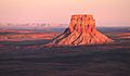
East aspect
|
|
| Highest point | |
| Elevation | 5,287 ft (1,611 m) |
| Prominence | 977 ft (298 m) |
| Isolation | 4.22 mi (6.79 km) |
| Parent peak | Point 5408 |
| Geography | |

Tower Butte
Location in Arizona

Tower Butte
Location in the United States
|
|
| Location | Navajo Reservation Coconino County, Arizona, U.S. |
| Parent range | Colorado Plateau |
| Topo map | USGS Wild Horse Mesa |
| Geology | |
| Age of rock | Jurassic |
| Type of rock | Entrada Sandstone |
| Climbing | |
| First ascent | October 23, 1994 |
| Easiest route | class 5.10a climbing |
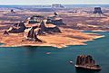
Tower Butte is a tall, flat-topped mountain in northern Arizona. It stands 5,287 feet (1,611 meters) high. This amazing landmark is located south of Lake Powell, on land belonging to the Navajo Nation. It's a popular spot for helicopter tours, offering incredible views of the area.
About Tower Butte
Tower Butte is a type of landform called a butte. A butte is like a small, isolated mountain. It has very steep sides and a flat top. Tower Butte is made mostly of sandstone, which is a type of rock formed from sand.
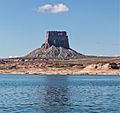
This impressive butte is about 9 miles (14.5 km) northeast of the town of Page. It rises over 1,000 feet (305 meters) above the land around it. This makes it a very noticeable landmark. Rainwater that falls on Tower Butte flows into Lake Powell. This lake is part of the huge Colorado River system.
Exploring Tower Butte
The first people to climb Tower Butte using ropes were Jason Keith and David Insley. They reached the top on October 23, 1994. However, they found signs that others had been there before them. They saw litter from helicopter landings.
Today, a company from Page offers helicopter sightseeing flights to the top of Tower Butte. Tourists can land on the flat summit. From there, they get amazing views of the Glen Canyon National Recreation Area, Lake Powell, and Navajo Mountain.
Gallery
-
From the northwest at Alstrom Point
-
-
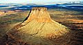
Aerial view from northwest
-
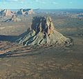
From the north
-
Tower Butte in upper right corner
.jpg)


Climate Around Tower Butte
Tower Butte is in an arid climate zone. This means it has very hot and dry summers. Winters are chilly, but there is very little snow. It is located on the southern edge of the Great Basin Desert. This desert is part of the larger Colorado Plateau.
The best times to visit Tower Butte are during spring and fall. The weather is usually more pleasant then.
| Climate data for Page, Arizona | |||||||||||||
|---|---|---|---|---|---|---|---|---|---|---|---|---|---|
| Month | Jan | Feb | Mar | Apr | May | Jun | Jul | Aug | Sep | Oct | Nov | Dec | Year |
| Record high °F (°C) | 64 (18) |
72 (22) |
82 (28) |
91 (33) |
102 (39) |
107 (42) |
109 (43) |
106 (41) |
100 (38) |
93 (34) |
77 (25) |
66 (19) |
109 (43) |
| Mean daily maximum °F (°C) | 43.1 (6.2) |
50.3 (10.2) |
59.5 (15.3) |
68.5 (20.3) |
78.5 (25.8) |
90.2 (32.3) |
95.1 (35.1) |
92.0 (33.3) |
83.5 (28.6) |
69.7 (20.9) |
53.8 (12.1) |
43.7 (6.5) |
69.0 (20.6) |
| Mean daily minimum °F (°C) | 26.3 (−3.2) |
30.4 (−0.9) |
37.0 (2.8) |
43.6 (6.4) |
52.6 (11.4) |
62.3 (16.8) |
68.3 (20.2) |
66.4 (19.1) |
58.4 (14.7) |
46.6 (8.1) |
34.7 (1.5) |
27.1 (−2.7) |
46.1 (7.8) |
| Record low °F (°C) | −11 (−24) |
6 (−14) |
18 (−8) |
25 (−4) |
31 (−1) |
44 (7) |
56 (13) |
46 (8) |
40 (4) |
24 (−4) |
16 (−9) |
1 (−17) |
−11 (−24) |
| Average precipitation inches (mm) | 0.61 (15) |
0.48 (12) |
0.65 (17) |
0.50 (13) |
0.40 (10) |
0.14 (3.6) |
0.58 (15) |
0.69 (18) |
0.66 (17) |
0.99 (25) |
0.56 (14) |
0.48 (12) |
6.74 (171.6) |
| Average snowfall inches (cm) | 2.1 (5.3) |
1.2 (3.0) |
0.2 (0.51) |
0 (0) |
0 (0) |
0 (0) |
0 (0) |
0 (0) |
0 (0) |
0 (0) |
0.5 (1.3) |
1.4 (3.6) |
5.4 (13.71) |
| Average precipitation days (≥ 0.01 in) | 4.5 | 4.0 | 5.2 | 3.5 | 3.2 | 1.7 | 4.6 | 5.2 | 4.5 | 4.3 | 3.2 | 3.9 | 47.8 |
| Average snowy days (≥ 0.1 in) | 0.9 | 0.6 | 0.3 | 0 | 0 | 0 | 0 | 0 | 0 | 0 | 0.2 | 0.6 | 2.6 |
| Source: NOAA | |||||||||||||
