Hite, Utah facts for kids
Quick facts for kids
Hite
|
|
|---|---|
|
Ranger District
|
|

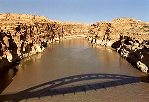
Shadow of the Hite Crossing Bridge, almost 5 miles from where Hite is submerged by Lake Powell.
|
|
| Country | United States |
| State | Utah |
| County | San Juan |
| Established | 1881 |
| Named for | Cass Hite |
| Elevation | 3,704 ft (1,129 m) |
| GNIS feature ID | 1455095 |
Imagine a town that disappeared underwater! That's the story of historic Hite. It was once a small settlement in San Juan County, Utah, United States. Today, Hite is a ghost town because it is completely covered by the waters of Lake Powell.
Lake Powell is a large reservoir created by the Glen Canyon Dam. The land where Hite once stood is now part of the Glen Canyon National Recreation Area. This area is managed by the National Park Service. It is a popular spot for people to visit and enjoy outdoor activities.
Hite was named after an early settler named Cass Hite. Even though the town is gone, its name lives on. The name "Hite" is still used for a recreation area at the northern end of Lake Powell. You can also find the Hite Crossing Bridge nearby. This bridge carries Utah State Route 95 over the Colorado River. It helps connect different parts of the area around the lake.
The Climate of Hite
The area where Hite was located has a semi-arid climate. This means it is very dry, almost like a desert. It doesn't get much rain or snow. This type of climate is often called "BSk" on special climate maps. Even though it's dry, the Colorado River brought life to the area before the lake was formed.
 | Claudette Colvin |
 | Myrlie Evers-Williams |
 | Alberta Odell Jones |


