
Comb Ridge facts for kids
Quick facts for kids Comb RidgeTséyíkʼáán |
|
|---|---|

Comb Ridge from the air, above Bluff Utah and the San Juan River
|
|
| Location | Utah and Arizona |
| Nearest city | Blanding, Utah |
| Designated | 1976 |

Comb Ridge (which is called Tséyíkʼáán in the Navajo language) is a long, straight rock formation in southeastern Utah and northeastern Arizona. It stretches for almost 80 miles (about 129 kilometers) from north to south.
This unique ridge is a type of geological feature called a monocline. Imagine a flat stack of blankets that has been pushed up in the middle, but only on one side, creating a gentle slope. That's kind of what a monocline is!
The northern part of Comb Ridge meets the Abajo Mountains near Blanding, Utah. It then goes south towards the San Juan River. After the river, the ridge turns southwest and becomes less noticeable as it continues towards Laguna Creek, near Kayenta, Arizona.
In 1976, Comb Ridge was named a National Natural Landmark. This is because it's the only place in North America where scientists have found fossils of a very old animal called a tritylodont. Parts of the ridge in Utah are also protected as part of the Bears Ears National Monument.
What is Comb Ridge Made Of?
Comb Ridge is made up of many layers of rock that have been tilted. These layers include different types of sandstone and other rocks. They were formed during different time periods, like the Jurassic period (when dinosaurs lived), the Triassic period, and the Permian period.
The way Comb Ridge looks today is because of a very deep crack, or fault, in the Earth's crust. This fault caused the layers of rock to bend and lift up, creating the long, comb-like shape we see.
A Look Back in Time: History of Comb Ridge
Comb Ridge has been an important place for people for a very long time. You can find signs of the Ancestral Puebloans (ancient people who lived in the Southwest) along the southern part of the ridge. They built amazing homes and structures into the cliffs.
Early explorers like John N. Macomb and Ferdinand Vandeveer Hayden were among the first to map and describe Comb Ridge in the late 1800s. The ridge and a nearby area called Butler Wash got their current names in 1884.
Many cliff dwellings, which are homes built into the sides of cliffs, can be found all along Comb Ridge. These show us how people lived here hundreds of years ago.
Images for kids
-
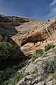
Monarch Cave Ruin cliff dwelling on Comb Ridge
-
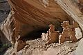
A closer look at Monarch Cave Ruin.
-
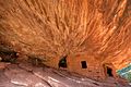
House on Fire Ruin, another cliff dwelling near Comb Ridge.
-
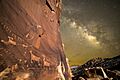
The Procession Panel, an ancient rock carving (petroglyph).


