
Sunset Crater facts for kids
Quick facts for kids Sunset Crater |
|
|---|---|

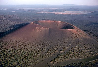
Sunset Crater from the Cinder Hills
|
|
| Highest point | |
| Elevation | 8,042 ft (2,451 m) NAVD 88 |
| Prominence | 999 ft (304 m) |
| Geography | |

Sunset Crater
Location in Arizona
|
|
| Location | Coconino County, Arizona, U.S. |
| Topo map | USGS Sunset Crater East |
| Geology | |
| Age of rock | ~950 years |
| Mountain type | Cinder cone |
| Volcanic field | San Francisco volcanic field |
| Last eruption | 1075 ± 25 years |
| Climbing | |
| Easiest route | Hike |
| Sunset Crater Volcano National Monument | |
|---|---|
|
IUCN Category III (Natural Monument)
|
|
|
Sunset Crater Volcano National Monument
Location in Arizona

Sunset Crater Volcano National Monument
Location in the United States
|
|
| Nearest city | Flagstaff, AZ |
| Area | 3,040 acres (12.3 km2) |
| Established | May 26, 1930 |
| Visitors | 104,583 (in 2018) |
| Governing body | National Park Service |
| Website | Sunset Crater Volcano National Monument |
Sunset Crater is a special kind of volcano called a cinder cone. It is located north of Flagstaff in Arizona, USA. This volcano is found inside the Sunset Crater Volcano National Monument.
Sunset Crater is the youngest volcano in a group known as the San Francisco volcanic field. This field is connected to the nearby San Francisco Peaks.
Contents
How Sunset Crater Formed
When Did the Volcano Erupt?
Scientists first thought the eruption that created Sunset Crater happened around AD 1064–1065. They figured this out by looking at tree rings. However, newer studies of the land and old settlements suggest the eruption was closer to AD 1085.
What Happened During the Eruption?
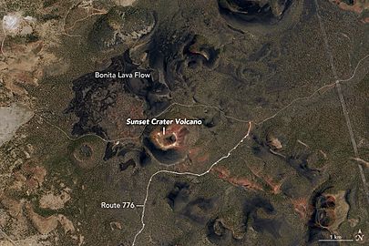
The main part of the eruption came from Sunset Crater itself. It sent out two big lava flows called Bonito and Kana-a. The Bonito flow went about 2.5 kilometers (1.5 miles) to the northwest. The Kana-a flow stretched about 9.6 kilometers (6 miles) to the northeast.
Other cracks in the ground, about 10 kilometers (6 miles) long, also erupted. These cracks created smaller lava flows and piles of rock to the east. The eruption covered a huge area, more than 2,100 square kilometers (810 square miles), with ash and small rocks. This forced the local Sinagua people to leave their homes for a while.
Life After the Eruption
Even though the eruption was powerful, life has returned. The volcano is now covered with pine trees and colorful wildflowers. One special flower, the Sunset Crater Beardtongue, is named after the volcano. Today, Sunset Crater is an extinct volcano, meaning it will not erupt again.
Exploring Sunset Crater
Hiking and Trails
You can explore the area around Sunset Crater. There is a short trail at the base of the volcano. This trail lets you see the amazing landscape.
Years ago, people could hike to the very top of the crater. But too many hikers caused damage to the volcano's slopes. Because of this, the National Park Service closed the trail to the summit in 1973. This helps protect the natural environment.
The Bonito Lava Flow
The trail at the base of the volcano goes near the Bonito Lava Flow. This lava flow is very old but still looks fresh and black. It destroyed the forest in its path when it flowed. The lava also formed an "ice cave" or lava tube. This cave is now closed to visitors because parts of it have collapsed.
2015 Eruption Scare
On June 5, 2015, some people thought Sunset Crater was erupting again. A website showed satellite images that looked like steam was coming from the crater. This caused some worry.
However, it was quickly discovered that the "steam" was actually smoke from a nearby forest fire. Geologists confirmed that Sunset Crater is an extinct volcano. This means it cannot erupt anymore.
Sunset Crater Volcano National Monument
Protecting a Natural Wonder
Sunset Crater Volcano National Monument is a U.S. National Monument in Arizona. It was created to protect Sunset Crater and the surrounding area. The monument is part of the larger San Francisco Volcanic Field.
The National Park Service manages the monument. They also manage the nearby Wupatki National Monument.
How the Monument Was Created
In 1928, a movie company called Famous Players-Lasky Corporation had a plan. They wanted to blow up parts of Sunset Crater with explosives. This was for a movie called Avalanche.
Many people were upset about this plan. Their strong protests helped convince President Herbert Hoover to create Sunset Crater Volcano National Monument in 1930. This protected the volcano from harm.
Visiting the Monument
The monument has a 1.6-kilometer (1-mile) self-guided loop trail. This trail is at the base of Sunset Crater. Remember, hiking to the top is not allowed to protect the volcano.
There is also a visitor center near the park entrance. It is about 15 kilometers (9 miles) north of Flagstaff, Arizona, along U.S. Highway 89.
Images for kids
-
Sunset Crater from an air photo in 1996
-
An aerial view of Sunset Crater in 2005
-
Sunset Crater seen from Landsat satellite in 2016
-
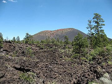
A lava field at the base of the crater, about 1000 years old.


