Navajo National Monument facts for kids
Quick facts for kids Navajo National Monument |
|
|---|---|
|
IUCN Category III (Natural Monument)
|
|
Keet Seel cliff dwellings
|
|
| Location | Navajo and Coconino counties, Arizona, USA |
| Nearest city | Kayenta, Arizona |
| Area | 360 acres (150 ha) |
| Created | March 20, 1909 |
| Visitors | 61,195 (in 2018) |
| Governing body | National Park Service |
| Website | Navajo National Monument |
|
Navajo National Monument
|
|
| NRHP reference No. | 66000176 |
| Added to NRHP | October 15, 1966 |
Navajo National Monument is a special place in northern Arizona, USA. It's located on the Navajo Nation land. This monument was created to protect three amazing ancient cliff dwellings. These homes were built by the Ancestral Puebloan people long ago.
The three main sites are Keet Seel (which means "Broken Pottery"), Betatakin (meaning "Ledge House"), and Inscription House. The monument sits high on the Shonto plateau, looking over the beautiful Tsegi Canyon. Visitors can explore a center with a museum, walk on short trails, and even camp for free.
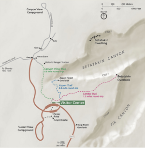
One easy trail, called the Sandal Trail, is about 1.3 miles long. It leads to a viewpoint where you can see the Betatakin ruins across a deep canyon. This is the only way to see Betatakin without joining a guided tour. Park rangers offer free tours to Betatakin and longer hikes to Keet Seel. The Inscription House site has been closed to visitors for many years.
Navajo National Monument was officially recognized as a historic place on October 15, 1966.
Contents
Exploring Keet Seel
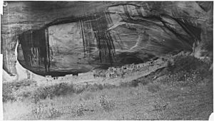
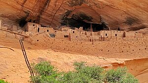
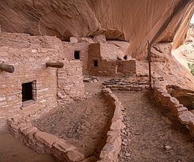
Keet Seel (pronounced Kįtsʼiil) means "broken pottery scattered around" in the Navajo language. It's a very well-preserved cliff dwelling built by the ancient Ancestral Pueblo people. You can find it in a part of the Tsegi Canyon.
People first started living here around the year 1250. Many people were moving to large sites like Keet Seel in the American Southwest during this time. A lot of building happened at Keet Seel between 1272 and 1275. Construction then slowed down and stopped completely by 1286. After that, no new buildings were made until the site was left empty about 20 years later.
At its busiest, about 150 people might have lived in Keet Seel. The very dry weather and the natural overhang of the cliff helped keep the homes and artifacts safe. Many experts believe Keet Seel is one of the best-preserved large ancient ruins in the Southwest.
Discovering Betatakin
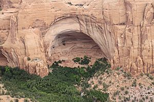
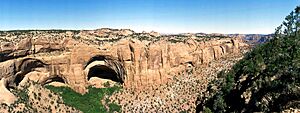
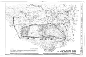
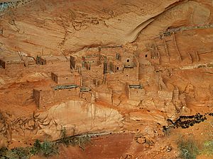
Betatakin means "House Built on a Ledge" in Navajo. The Hopi people call it Talastima, which means "Place of the Corn Tassel." Betatakin is smaller than Keet Seel. It had about 120 rooms when people left it. Like Keet Seel, Betatakin was made from sandstone, mud, and wood. Today, only about 80 rooms remain because some rocks have fallen.
Betatakin has just one Kiva (a special ceremonial room), while Keet Seel has several. Betatakin was built inside a giant alcove, which is like a huge cave opening. This alcove is about 452 feet high and 370 feet wide. The building of Betatakin happened between 1267 and 1286.
Scientists first studied Betatakin in 1909. They continued to learn more about it in the 1950s and 1960s. During its busiest time, about 125 people lived there.
How These Sites Were Found
Navajo people living in the area knew about Keet Seel for many years. The first Europeans, the Wetherill brothers, arrived in 1895. The Wetherills were a ranching family from Colorado. They were very interested in the Ancestral Pueblo people. They went on many trips into the Kayenta region and found many sites that Europeans hadn't seen before.
The Wetherills took many artifacts from the ruins. The Navajo people had left these items untouched for centuries. Richard Wetherill is known for using the word "Anasazi" to describe these ancient people. This word means "Ancient Enemy Ancestors" in Navajo. Betatakin was first recorded in 1909 after Navajo National Monument was created. John Wetherill, Byron Cummings, and Navajo guide Clatsozen Benully were the first to record it.
The Wetherill brothers used to give tours of the sites in Tsegi Canyon. Later, they helped protect these important places. The artifacts they removed were sold or sent to different places. Today, it's hard to know where many of them are.
What People Ate
The Ancestral Pueblo people who lived here were farmers. They grew most of their food. Their main crop at Navajo National Monument was maize (corn). They also grew beans and cucurbits (like squash). Besides farming, they hunted wild animals that lived in the area.
It's believed they lived in these cave dwellings to save the flat land for growing crops. By living in the caves instead of on the mesas or canyon floors, they could use more land for farming. This was important for survival in this high, desert environment. The ruins at Navajo National Monument have many rooms used for storage. This suggests they grew enough crops to need a lot of space to keep them.
Homes and Buildings
The buildings inside these cave sites were mostly made from sandstone blocks. These blocks were held together with mud and mortar. Unlike earlier villages built on top of mesas, these cliff dwellings show a trend. More people were moving into close, protected areas during the late 1200s.
Many of the buildings here are similar to other Ancestral Pueblo styles. They include Kivas (round ceremonial rooms), a circular tower at Keet Seel, and pit-houses. However, the limited space in the caves meant people lived very close together. At its busiest, Keet Seel had over 150 rooms and 6 kivas. Betatakin had about 120 rooms and one kiva.
They also used jacal walls. These walls were made from upright wooden poles covered with mud. The dry conditions and protection from the cliff at Keet Seel helped preserve these building styles.
Some structures were likely built at the base of the cliff. But these areas were not protected by the overhanging rock. So, they were destroyed by weather and erosion over time. At Keet Seel, scientists found evidence of 25 groups of rooms under the overhang. Each group had a living room and one to four storage rooms around a small courtyard. This layout was much like the Pueblo III structures at Mesa Verde. Betatakin had about 20 room groups.
Why People Left
Many archaeologists agree that people left this region of the Southwest quite suddenly. But they debate why. Scientists have found that there was much less rain between 1276 and 1299 AD. This time is known as the "Great Drought." Less rainfall in an already dry place made it very hard for farmers. Their crops, which they depended on, suffered greatly.
Later evidence suggests that deep arroyos (gullies) started forming. This would have damaged the remaining farmland. More sediment (dirt) covered the fields, and the water level dropped. This made the land unsuitable for farming.
Whatever the exact reasons, by the late 1200s, the Ancestral Pueblo people moved away. They went to places with more stable water sources. This suggests the land here could no longer support the large populations that once lived in these amazing cave sites.
Hopi legends tell a different story. Their oral traditions say the area was left as part of a spiritual journey. The Snake Clan and Horn Clan lived in the Navajo National Monument ruins. The Horn Clan supposedly forced the Snake Clan out. This was because the Snake Clan children were biting other children, causing death. This story might be a way to explain a real event where one group made another leave.
How the Monument Was Created
President William Taft first made this area a national monument in 1909. In 1912, he made the monument smaller. It became three specific areas of land. One area of 160 acres surrounded Betatakin. Another 160-acre area surrounded Keet Seel. A smaller 40-acre area surrounded Inscription House.
Weather at the Monument
Navajo National Monument has a cold, dry climate. Winters are cold, and summers are hot.
| Climate data for Navajo National Monument, Arizona, 1991–2020 normals, extremes 1939–present | |||||||||||||
|---|---|---|---|---|---|---|---|---|---|---|---|---|---|
| Month | Jan | Feb | Mar | Apr | May | Jun | Jul | Aug | Sep | Oct | Nov | Dec | Year |
| Record high °F (°C) | 61 (16) |
69 (21) |
76 (24) |
90 (32) |
94 (34) |
101 (38) |
100 (38) |
98 (37) |
96 (36) |
93 (34) |
70 (21) |
61 (16) |
101 (38) |
| Mean maximum °F (°C) | 51.8 (11.0) |
55.9 (13.3) |
65.6 (18.7) |
74.1 (23.4) |
82.8 (28.2) |
91.3 (32.9) |
93.5 (34.2) |
90.7 (32.6) |
86.0 (30.0) |
77.0 (25.0) |
64.4 (18.0) |
54.1 (12.3) |
94.5 (34.7) |
| Mean daily maximum °F (°C) | 39.9 (4.4) |
43.8 (6.6) |
52.5 (11.4) |
60.7 (15.9) |
70.8 (21.6) |
82.1 (27.8) |
85.7 (29.8) |
82.9 (28.3) |
76.2 (24.6) |
63.9 (17.7) |
50.7 (10.4) |
40.3 (4.6) |
62.5 (16.9) |
| Daily mean °F (°C) | 31.0 (−0.6) |
34.1 (1.2) |
41.4 (5.2) |
47.9 (8.8) |
57.5 (14.2) |
68.3 (20.2) |
72.9 (22.7) |
70.6 (21.4) |
63.9 (17.7) |
52.5 (11.4) |
40.5 (4.7) |
31.2 (−0.4) |
51.0 (10.6) |
| Mean daily minimum °F (°C) | 22.0 (−5.6) |
24.5 (−4.2) |
30.2 (−1.0) |
35.1 (1.7) |
44.3 (6.8) |
54.6 (12.6) |
60.1 (15.6) |
58.2 (14.6) |
51.7 (10.9) |
41.2 (5.1) |
30.2 (−1.0) |
22.1 (−5.5) |
39.5 (4.2) |
| Mean minimum °F (°C) | 7.3 (−13.7) |
10.3 (−12.1) |
16.6 (−8.6) |
20.4 (−6.4) |
29.3 (−1.5) |
41.0 (5.0) |
51.0 (10.6) |
49.0 (9.4) |
38.4 (3.6) |
25.4 (−3.7) |
13.8 (−10.1) |
7.8 (−13.4) |
2.8 (−16.2) |
| Record low °F (°C) | −11 (−24) |
−14 (−26) |
2 (−17) |
0 (−18) |
19 (−7) |
28 (−2) |
30 (−1) |
33 (1) |
23 (−5) |
7 (−14) |
−2 (−19) |
−14 (−26) |
−14 (−26) |
| Average precipitation inches (mm) | 1.17 (30) |
1.03 (26) |
0.79 (20) |
0.64 (16) |
0.58 (15) |
0.18 (4.6) |
1.23 (31) |
1.45 (37) |
1.23 (31) |
0.96 (24) |
0.69 (18) |
1.16 (29) |
11.11 (282) |
| Average snowfall inches (cm) | 8.3 (21) |
9.1 (23) |
3.7 (9.4) |
3.3 (8.4) |
0.4 (1.0) |
0.0 (0.0) |
0.0 (0.0) |
0.0 (0.0) |
0.0 (0.0) |
0.3 (0.76) |
3.2 (8.1) |
7.2 (18) |
35.5 (90) |
| Average precipitation days (≥ 0.01 inch) | 5.2 | 5.3 | 4.1 | 2.8 | 3.0 | 1.3 | 5.6 | 6.7 | 4.9 | 3.5 | 3.2 | 4.0 | 49.6 |
| Average snowy days (≥ 0.1 inch) | 3.8 | 3.5 | 2.0 | 1.0 | 0.1 | 0.0 | 0.0 | 0.0 | 0.0 | 0.3 | 1.9 | 3.4 | 16.0 |
| Source: NOAA | |||||||||||||
See also
 In Spanish: Monumento nacional Navajo para niños
 | Audre Lorde |
 | John Berry Meachum |
 | Ferdinand Lee Barnett |


