
Walnut Canyon National Monument facts for kids
Quick facts for kids Walnut Canyon National Monument |
|
|---|---|
|
IUCN Category III (Natural Monument)
|
|
 |
|
| Location | Coconino County, Arizona, United States |
| Nearest city | Flagstaff, Arizona |
| Area | 3,529 acres (14.28 km2) |
| Created | November 30, 1915 |
| Visitors | 167,736 (in 2018) |
| Governing body | National Park Service |
| Website | Walnut Canyon National Monument |
|
Walnut Canyon National Monument
|
|
| Nearest city | Flagstaff, Arizona |
| Area | 2,249.5 acres (910.3 ha) |
| NRHP reference No. | 66000174 |
| Added to NRHP | October 15, 1966 |
Walnut Canyon National Monument is a special place in Arizona, USA. It's about 10 miles (16 km) southeast of Flagstaff. The canyon rim is very high, at 6,690 feet (2,039 meters). The canyon floor is 350 feet (107 meters) lower.
You can walk a 0.9-mile (1.4 km) trail down into the canyon. This trail takes you past 25 ancient cliff dwelling rooms. These homes were built by the Sinagua people. They lived in Walnut Canyon from about 1100 to 1250 AD. You can also see other Sinagua homes at nearby Tuzigoot and Montezuma Castle.
Contents
Discovering Ancient Homes: The Sinagua People

The word "Sinagua" means "without water" in Spanish. This name shows how amazing these people were. They lived in a very dry area. The Sinagua became experts at saving water. They also knew how to survive long dry periods.
Historians believe the Sinagua were active traders. Their goods and ideas traveled far. They traded with people as far away as the Gulf of Mexico. Some even think they traded with groups in Central America.
Why the Sinagua Left Walnut Canyon
The Sinagua people lived in Walnut Canyon for many years. But around 1250 AD, they left their homes. No one knows exactly why they left. Some think they moved because of fear from other tribes. Others believe a long drought made them leave. It remains a mystery today.
The Sinagua left behind more than 80 cliff dwellings. These homes were built under natural limestone ledges. The canyon walls were shaped by water over millions of years. The Sinagua used these natural shelters. They built their homes between 1125 and 1250 AD.
Life in the Cliff Dwellings
The homes were small but cozy. They were big enough for families to cook and sleep. Most of the rooms are near the loop trail. A typical room was about 6.5 feet (2 meters) high. It was also about 20 feet (6 meters) long and 10 feet (3 meters) deep.
Water was very important for the Sinagua. The canyon's dry climate made water precious. It is still vital for plants and animals today. Walnut Canyon has many different plants. There are over 387 species, like the Prickly Pear cactus. The Arizona Black Walnut tree also grows here. This rich plant life likely helped the Sinagua decide to settle here.

There are other ancient ruins nearby. These are in a 20 by 10-mile (32 by 16 km) area. However, these other sites are not open to the public. You can see more dwellings in the canyon east of the Monument. But it is against the law to enter those areas.
Protecting Walnut Canyon's History
President Woodrow Wilson made Walnut Canyon a national monument. This happened on November 30, 1915. He wanted to protect the ancient cliff dwellings. The National Park Service now manages the monument. It has been doing so since August 10, 1933.
Today, visitors can explore the canyon. There are trails to see the dwellings up close.
Exploring Walnut Canyon's Geology

Walnut Canyon is part of the Colorado Plateau. The canyon cuts through ancient rock layers. These layers include Kaibab Limestone, Toroweap Formation, and Coconino Sandstone. The Kaibab Limestone also forms the rim of the Grand Canyon. You can see cool wavy patterns in the Coconino Sandstone. These patterns are called crossbedding.
Walnut Creek flows through the canyon. It carved the canyon to be 600 feet (183 meters) deep. The creek flows east and joins the Little Colorado River. Eventually, its water reaches the Grand Canyon.
Plants and Trees of the Canyon
The creek helps many plants grow here. The shaded, north-facing walls have fir and ponderosa pine trees. The sunny, south-facing slopes have agaves and cacti. These include opuntia, echinocereus, and cholla. The canyon floor is home to several types of walnut trees. This is how the canyon got its name!
The canyon walls have three main rock layers. The top layer is Kaibab Limestone. This is where the cliff dwellings are found. Below that are slopes of the Toroweap Formation. The lowest layer is the sheer Coconino Sandstone. Over time, parts of the limestone wore away. This created alcoves, which the Sinagua used as homes.
Today, about 3,600 acres of land are protected. This area preserves both ancient history and nature.
Walnut Canyon's Climate
Not all of Arizona is a hot, dry desert. Walnut Canyon is high up, at 6,690 feet (2,039 meters). This means it gets snow in winter. Summers are hot with afternoon thunderstorms. Spring brings strong, gusty winds.
Even with this changing weather, the Sinagua people thrived. They were able to grow important crops. These included maize (corn), beans, and squash.
| Climate data for Walnut Canyon National Monument, Arizona, 1991–2020 normals, extremes 1910–present | |||||||||||||
|---|---|---|---|---|---|---|---|---|---|---|---|---|---|
| Month | Jan | Feb | Mar | Apr | May | Jun | Jul | Aug | Sep | Oct | Nov | Dec | Year |
| Record high °F (°C) | 70 (21) |
69 (21) |
79 (26) |
84 (29) |
92 (33) |
100 (38) |
102 (39) |
98 (37) |
96 (36) |
88 (31) |
78 (26) |
69 (21) |
102 (39) |
| Mean maximum °F (°C) | 58.4 (14.7) |
62.2 (16.8) |
69.8 (21.0) |
76.4 (24.7) |
84.9 (29.4) |
93.7 (34.3) |
95.8 (35.4) |
90.9 (32.7) |
87.9 (31.1) |
79.9 (26.6) |
69.4 (20.8) |
61.4 (16.3) |
97.0 (36.1) |
| Mean daily maximum °F (°C) | 44.7 (7.1) |
48.7 (9.3) |
56.1 (13.4) |
61.8 (16.6) |
71.0 (21.7) |
82.1 (27.8) |
85.9 (29.9) |
82.3 (27.9) |
77.6 (25.3) |
67.4 (19.7) |
54.8 (12.7) |
44.6 (7.0) |
64.7 (18.2) |
| Daily mean °F (°C) | 32.5 (0.3) |
35.8 (2.1) |
42.3 (5.7) |
47.8 (8.8) |
55.6 (13.1) |
66.4 (19.1) |
71.5 (21.9) |
68.7 (20.4) |
62.0 (16.7) |
50.9 (10.5) |
41.3 (5.2) |
32.7 (0.4) |
50.6 (10.4) |
| Mean daily minimum °F (°C) | 20.3 (−6.5) |
22.8 (−5.1) |
28.4 (−2.0) |
33.8 (1.0) |
40.3 (4.6) |
50.8 (10.4) |
57.0 (13.9) |
55.1 (12.8) |
46.4 (8.0) |
34.5 (1.4) |
27.8 (−2.3) |
20.8 (−6.2) |
36.5 (2.5) |
| Mean minimum °F (°C) | 5.3 (−14.8) |
7.5 (−13.6) |
14.2 (−9.9) |
22.1 (−5.5) |
27.8 (−2.3) |
37.5 (3.1) |
47.6 (8.7) |
46.1 (7.8) |
34.6 (1.4) |
24.6 (−4.1) |
13.1 (−10.5) |
4.6 (−15.2) |
0.5 (−17.5) |
| Record low °F (°C) | −11 (−24) |
−3 (−19) |
1 (−17) |
17 (−8) |
22 (−6) |
30 (−1) |
38 (3) |
40 (4) |
29 (−2) |
11 (−12) |
3 (−16) |
−8 (−22) |
−11 (−24) |
| Average precipitation inches (mm) | 1.27 (32) |
1.73 (44) |
1.50 (38) |
0.85 (22) |
0.59 (15) |
0.26 (6.6) |
2.55 (65) |
3.39 (86) |
1.61 (41) |
1.19 (30) |
1.37 (35) |
1.23 (31) |
17.54 (445.6) |
| Average snowfall inches (cm) | 13.3 (34) |
11.0 (28) |
7.9 (20) |
5.5 (14) |
0.3 (0.76) |
0.0 (0.0) |
0.0 (0.0) |
0.0 (0.0) |
0.0 (0.0) |
1.1 (2.8) |
3.5 (8.9) |
9.8 (25) |
52.4 (133.46) |
| Average precipitation days (≥ 0.01 in) | 5.6 | 5.7 | 4.8 | 4.0 | 3.8 | 2.2 | 11.3 | 13.1 | 6.9 | 5.1 | 4.1 | 5.4 | 72.0 |
| Average snowy days (≥ 0.1 in) | 3.5 | 4.1 | 2.8 | 1.7 | 0.2 | 0.0 | 0.0 | 0.0 | 0.0 | 0.5 | 1.7 | 3.8 | 18.3 |
| Source 1: NOAA | |||||||||||||
| Source 2: National Weather Service | |||||||||||||
Visiting Walnut Canyon National Monument

The park is open almost every day of the year. It closes only on December 25. You can visit from 9:00 am to 5:00 pm MST. The entrance road, trails, and Visitor Center are all open.
Make sure to arrive early! The Island trail closes at 4 pm. This trail takes about 45–60 minutes to complete. The Rim trail closes at 4:30 pm. All visitors must be out of the park by 5:00 pm. The gates are closed from 5:00 pm to 9:00 am daily.
Walnut Canyon is easy to find. It's 7 miles (11 km) east of I-40. Take exit 204 and drive 3 miles (5 km) south. The park has a museum and a small visitor center. These are located high up on a cliff.
Many ancient homes were built around a U-shaped bend in the canyon. The creek circles around three sides of a high rocky area. This almost creates an "island." This area is now the main attraction of the monument.
Images for kids
-
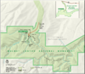
A map of Walnut Canyon National Monument.

