
Toroweap Formation facts for kids
Quick facts for kids Toroweap FormationStratigraphic range: Early Permian, 272–270Ma |
|
|---|---|

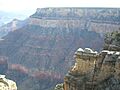
Toroweap formation in Grand Canyon National Park
|
|
| Type | Geological formation |
| Underlies | Kaibab Limestone-(Permian), Grand Canyon, North Rim, (Kaibab Plateau), also South Rim, and elsewhere in Arizona, Utah, Nevada |
| Overlies | Coconino Sandstone |
| Thickness | 200 feet (61 m) approximate maximum |
| Lithology | |
| Primary | gypsum & shale, also sandstone |
| Location | |
| Region | (southwest)-Colorado Plateau Northern Arizona, southeast Utah |
| Extent | Grand Canyon, North & South Rims, northeast Arizona, southeast Utah |
The Toroweap Formation is a special layer of rock that formed during the Middle Permian period. It looks like a thin, darker band of rock. You can see it sandwiched between two brighter rock layers: the Kaibab Limestone above it and the Coconino Sandstone below.
This rock layer is easy to spot in the Grand Canyon in Arizona, USA. You can find it on both the South and North Rims of the Grand Canyon. It's also present in parts of the Kaibab Plateau and the Walhalla Plateau. The Toroweap Formation can also be found in southeast Utah.
The Toroweap Formation is mostly made of gypsum, shale, and sandstone. When you look at photos, the strong Kaibab and Coconino layers often form cliffs. The softer Toroweap Formation, however, usually forms slopes or gentle hills. This is because it erodes more easily. If you look closely, you can see that the harder sandstone parts of the Toroweap still stand out as small cliffs.
You can also find cliffs made of the Toroweap Formation at Walnut Canyon National Monument. This park is about 70 miles southeast of the Grand Canyon, near Flagstaff, Arizona.
Contents
How the Toroweap Formation Was Made
The Toroweap Formation, along with the Kaibab Limestone and Coconino Sandstone, formed from ancient seas and wind-blown sand. An ocean once covered this area, coming from the west. This sea moved in and out over time.
The Coconino Sandstone formed from huge sand dunes on land. The Toroweap deposits were laid down near the shoreline, and the Kaibab Limestone formed in the deeper ocean. This means that these three different rock layers can actually be the same age in different places. In Arizona, the Toroweap Formation shows two times the ocean moved eastward. The easternmost points show where the ancient shoreline was.
What is the Toroweap Overlook?

The Toroweap Overlook is a famous viewpoint located on the north side of the Colorado River. It's about halfway through the Grand Canyon. This spot offers an amazing view of the West Grand Canyon. It's also where the Toroweap Fault, a crack in the Earth's crust, is located.
About nine miles to the west, you can find the Hurricane Fault. This fault runs roughly parallel to the Toroweap Fault. Both are near the Uinkaret Mountains. The Toroweap Overlook sits above the tough Tapeats Sandstone layer. Early photographers of the Grand Canyon visited this overlook in the 1800s.
Grand Canyon Rock Layers
Here are the main rock layers from the Permian period that you can see in the Grand Canyon, from top to bottom:
- 4-The Kaibab Limestone
- 3-The Toroweap Formation
- 2-The Coconino Sandstone
- 1B-The Hermit Formation
- 1A-The Esplanade Sandstone (This is also considered the top part of the Supai Group, which formed around the Pennsylvanian-Permian time.)
Images for kids
-
North Rim, Grand Canyon:
4-Permian formations:
-4-Kaibab Limestone
-3-Toroweap Formation
-2-Coconino Sandstone
-1-Hermit Formation
-X-(upon Supai Group "redbeds") -
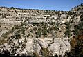
Toroweap Formation in Walnut Canyon, east of Flagstaff, Arizona
Darker middle section is Toroweap: above: (3): Kaibab Limestone; below: (1): Coconino Sandstone (showing fossil dunes)-(note erosion of dunes compared to horizontal bedding of Kaibab Limestone)


