Toroweap Overlook facts for kids
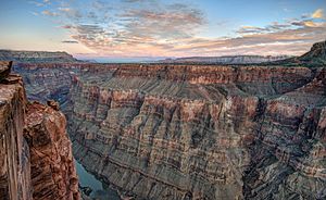
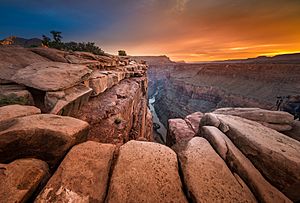
Toroweap Overlook (also known as Tuweep Overlook or Toroweap Point) is a special place in the Grand Canyon National Park in Arizona, United States. It's found in a quiet, far-off area on the North Rim of the Grand Canyon. This spot is unique because it's the only place in the whole National Park where you can see the Colorado River straight down below you! The overlook stands about 3,000 feet (914 meters) above the river.
Contents
What Do Toroweap and Tuweep Mean?
The words Toroweap and Tuweep are often used to talk about the same area. The word Tuweep comes from the Paiute language and means "the earth." It was used for an early settlement by Mormon pioneers in the valley. Today, the National Park Service uses "Tuweep" to describe the whole area.
Toroweap is also a Paiute word, meaning "dry or barren valley." This name strictly refers to the valley itself and the amazing viewpoint.
How the Grand Canyon Formed Here
At Toroweap, a soft rock layer called Hermit Shale is about 800 feet (244 meters) thick. This is much thicker than in other parts of the Grand Canyon! As this soft layer wore away, it created a wide, flat area called the Esplanade Platform, which sits on top of stronger rock called Esplanade Sandstone.
Later, a deep side canyon formed, leading down to the Colorado River. The Toroweap Fault, a crack in the Earth's crust, runs under this valley. Over time, volcanoes erupted along this fault, creating the Uinkaret volcanic field. Lava flows from these volcanoes filled up the side canyon. Eventually, a mix of sediment and lava filled the canyon up to the level of the Esplanade Platform.
Because of all this geology, the usual high outer rim of the Grand Canyon isn't here at Toroweap. This is why a road can follow the Toroweap Valley right to the edge of the Inner Gorge, giving you that incredible straight-down view of the river!
Just west of the overlook, you can see the Lava Falls. This is where ancient lava spilled over the rim and flowed down to the river. Nearby is Vulcan's Throne, which is a cinder cone (a small, cone-shaped volcano) from the time of all that volcanic activity.
Getting to Toroweap
Reaching Toroweap is an adventure because the roads are rough and unpaved. One main way is to take Mohave County road 109. It leaves State Route 389 about 8 miles (13 km) west of Fredonia and goes south for 61 miles (98 km) to the overlook.
Another route is the Clay Hole road from Colorado City, which is 56 miles (90 km) from Toroweap. However, it's very important not to use this road after it rains or snows, as it can become very difficult to drive. You can also get to Toroweap from St. George, Utah, by taking the "Mt. Trumbull/Main Street Route." This route is about 90 miles (145 km) long.
What's Available at Toroweap?
It's important to know that Toroweap is a very remote area. This means there is no lodging, food, gas, or water available. You need to bring everything you'll need with you!
The National Park Service sometimes has a ranger at the Tuweep ranger station, which is 6 miles (10 km) north of the overlook. Also, there is no cell phone service in this area, so be prepared to be disconnected.
There is a simple campground about 1 mile (1.6 km) north of the overlook. If you want to camp there, you need to make reservations several days in advance through the Grand Canyon National Park backcountry office.
Exploring Hiking Trails
There are a few trails to explore near Toroweap:
- The short Saddle Horse Loop Trail lets you reach more viewpoints close to the main overlook.
- The Tuckup Trail starts near the Toroweap campground.
- The Lava Falls Trail offers a challenging path down to the river from near Vulcan's Throne.
If you're looking for an easier way to reach the river, there's another hike that's much shorter. It only has about 1,000 feet (305 meters) of elevation change to the river, compared to 3,000 feet (914 meters) at Toroweap. This trail starts in Grand Canyon-Parashant National Monument at Whitmore Canyon Overlook. It's about 9 miles (14 km) west of Toroweap. To get there, take the Mt. Trumbull/Main Street Route west from Toroweap Valley past Mt. Trumbull, then turn south onto BLM1045 at the Mt. Trumbull Schoolhouse. This is a great option if you want to hike down to the Colorado River.
 | Laphonza Butler |
 | Daisy Bates |
 | Elizabeth Piper Ensley |


