Chinle Valley facts for kids
Quick facts for kids Chinle Valley |
|
|---|---|

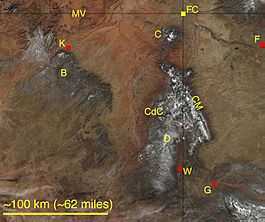
Chinle Valley, between Black Mesa west, and the mountain ranges to the east & southeast
|
|
| Length | 65 mi (105 km) N-S |
| Geography | |
| Country | United States |
| States | Arizona and Utah |
| Region | Colorado Plateau |
| Counties | Apache County, AZ and San Juan County, UT |
| Communities | |
| Borders on | |
| Rivers | Chinle Creek and Chinle Wash |
| Lake | Many Farms Lake |
The Chinle Valley is a long valley, about 65 miles (105 km) in length. It is mostly found in Apache County, Arizona. The valley's main waterway, Chinle Creek, flows north into Utah. It eventually joins the San Juan River.
This valley is part of the high Colorado Plateau region. Many smaller streams and washes flow into Chinle Wash. The valley is surrounded by higher land. To the west and southwest is Black Mesa. To the east and southeast are the Carrizo, Lukachukai, and Chuska Mountains. The southern part of the valley is near the Defiance Plateau. This area is also home to Canyon de Chelly National Monument.
The Chinle Valley is famous for a rock layer called the Chinle Formation. This formation is found in Arizona, Utah, New Mexico, Colorado, and western Texas. It shows us what the Earth was like millions of years ago. Monument Valley, a well-known area in Arizona and Utah, is located at the northwest edge of Chinle Valley.
Contents
Exploring Chinle Valley's Features
Chinle Valley stretches mainly from north to south. It is about 65 miles long. The valley has many smaller flat-topped hills called mesas. It also has many washes, which are dry streambeds that fill with water during rain. All these washes eventually flow into the Chinle Creek, which runs north through the valley.
The lowest point of the valley is in the north. This is where Chinle Creek continues its journey. It flows about 16 miles past Mexican Water, Arizona to meet the San Juan River in Utah.
Waterways and Lakes in the Valley
Chinle Valley is home to a couple of lakes. One of them is Many Farms Lake. You can find it on Sheep Dip Creek, near Many Farms, Arizona. This lake is about 1.5 miles from the main Chinle Wash.
Just a bit northeast of Many Farms Lake is Round Rock Reservoir. This reservoir is about 3 miles southeast of Round Rock, Arizona. It is located along Navajo Route 12. Water flows into it from Lukachukai Creek, which comes from the Lukachukai Mountains. Another stream, Agua Sal Creek, also feeds into it from the northwest Chuska Mountains.
Getting Around Chinle Valley
The main road that helps people travel through Chinle Valley is U.S. Route 191 (US 191). This highway runs from north to south through the valley.
Southern Valley Access
In Arizona, the town of Chinle, Arizona is located at the southern end of the valley. This is also where Chinle Wash flows out of Canyon de Chelly National Monument. Just north of Chinle on US 191 is Many Farms, Arizona. Here, Navajo Route 59 ends. Route 59 comes from the northwest, passing east of Kayenta. It follows the northeast side of Black Mesa.
Central Valley Access
Further north on US 191, you will find Round Rock, Arizona. This town is located near Lukachukai Creek. This creek and Agua Sal Creek are streams that flow into Chinle Wash from the southeast. Continuing north, Rock Point, Arizona is located near the center of Chinle Valley. It sits right on Chinle Wash. Several routes meet in the Rock Point area. Navajo Route 35 and Route 5040 are to the east. Navajo Route 8070 comes from the southwest. This route passes through the area of Trading Post Wash and the northern part of Carson Mesa. Navajo Route 18 connects from US 160 to the northwest.
Northern Valley Access
The northern end of Chinle Valley is where Mexican Water, Arizona is located. This town is between US 191, which is on the Utah–Arizona state line, and US 160, which is just south. US 160 runs east-west through the northern part of Chinle Valley. To the west, this route turns southwest. It follows Laguna Creek, which runs next to a southwest-trending section of Comb Ridge.
In Utah, US 191 leaves the northern Chinle Valley area near Mexican Water. It follows the path of Chinle Creek on its eastern side. US 191 then meets US 163 near the town of Bluff.
 | May Edward Chinn |
 | Rebecca Cole |
 | Alexa Canady |
 | Dorothy Lavinia Brown |


