
Black Creek (Arizona) facts for kids
Quick facts for kids Black Creek (Arizona) |
|
|---|---|

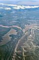
Aerial view with Black Creek flowing south through St. Michaels near the Window Rock Airport, near the top in the snowy area, through Hunters Point, near the bottom, along Indian Route 12
|
|
| Country | United States |
| Physical characteristics | |
| Main source | Defiance Plateau, Arizona; Chuska Mountains & Manuelito Plateau, New Mexico |
| River mouth | Houck, Arizona, confluence with Puerco River 6,035 ft (1,839 m) |
| Basin features | |
| Progression | Puerco—Little Colorado |
Black Creek is a river that flows for about 55 miles (89 kilometers) in the northeastern part of Arizona and a small part of northwestern New Mexico. It's like a smaller stream that feeds into a bigger river called the Puerco River.
This creek flows south, following the edge of a high, flat area called the Defiance Plateau. Near where Black Creek starts, there's a place called Red Lake (Arizona–New Mexico) in Red Valley. This area is close to Navajo, New Mexico.
As Black Creek flows south, it passes by several towns. Fort Defiance, Arizona, is on the western side of the creek. Other smaller streams that feed Black Creek come from the east, in New Mexico. The Chuska Mountains and the Manuelito Plateau form the eastern border of the Black Creek Valley.
The valley where Black Creek flows is mostly straight, running from north to south. It runs almost parallel to the border between Arizona and New Mexico. Only a tiny part of Black Creek actually flows through New Mexico, just south of Red Lake.
Where Does Black Creek Start and End?
Black Creek has a specific starting point and ending point.
- Where it ends (Mouth): Black Creek flows into the Puerco River near Houck, Arizona. This spot is in Apache County, Arizona, which is part of the Navajo Nation.
- Where it begins (Source): The creek starts in McKinley County, New Mexico, also within the Navajo Nation.
Traveling Along Black Creek
Many towns and roads follow the path of Black Creek. This makes it easier for people to travel and see the river.
- Window Rock and Nearby Towns:
* South of Window Rock, Arizona, you can find towns like St. Michaels, Arizona and Hunters Point, Arizona. * Arizona State Route 264 and New Mexico State Road 264 are important roads that run through this area. * Tse Bonito, New Mexico is another town near Window Rock.
- Oak Springs Area:
* Further south, Black Creek flows through Oak Springs, Arizona. This area has its own small valley called Oak Springs Valley. * Indian Route 123 (IR-123) and Indian Route 124 (IR-124) are local roads that help people get around here.
- North of Window Rock:
* North of Window Rock, you'll find Fort Defiance, Arizona and Navajo, New Mexico. * Sawmill, Arizona, is located northwest of Fort Defiance on Indian Route 7 (IR-7). This town used to have a busy sawmill.
- Main Roads Along the Creek:
* Indian Route 12 (IR-12) is a main road that runs north and south along Black Creek and through the Black Creek Valley. * Near Window Rock, IR-12 runs along the east side of the creek. * Near Fort Defiance, IR-12 crosses into New Mexico and goes towards Navajo, New Mexico, near Red Lake. * In New Mexico, IR-12 becomes New Mexico State Road 134. It then connects to U.S. Route 491. * South of Oak Springs, IR-12 eventually leads to Interstate 40 in Arizona, a major highway.
Images for kids
-
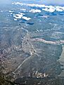
Just south of Hunters Point, Black Creek flows through Oak Springs, Arizona. Indian Route 12 is in the front.
-
Black Creek flows towards the Puerco River at Houck, Arizona.


