Tse Bonito, New Mexico facts for kids
Quick facts for kids
Tse Bonito, New Mexico
|
|
|---|---|

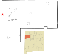
Location in McKinley County and the state of New Mexico
|
|
| Country | United States |
| State | New Mexico |
| County | McKinley |
| Area | |
| • Total | 6.81 sq mi (17.6 km2) |
| • Land | 6.81 sq mi (17.6 km2) |
| • Water | 0.00 sq mi (0 km2) |
| Elevation | 7,054 ft (2,150 m) |
| Population
(2020)
|
|
| • Total | 380 |
| • Density | 55.69/sq mi (21.50/km2) |
| Time zone | UTC-7 (Mountain (MST)) |
| • Summer (DST) | UTC-6 (MDT) |
| Area code(s) | 505 |
| FIPS code | 35-79885 |
| GNIS feature ID | 2409353 |
Tse Bonito (in Navajo: Tsé Binííʼtóhí) is a small community in McKinley County, New Mexico, United States. It is called a census-designated place (CDP). This means it's an area that looks like a town but isn't officially a city or village.
Tse Bonito is close to Window Rock, Arizona. Window Rock is important because it's where the government of the Navajo Nation is located. In 2020, about 380 people lived in Tse Bonito.
Contents
Geography of Tse Bonito
Tse Bonito is in the western part of McKinley County. Its western edge is right along the border with Arizona. The community of Black Hat is to its southeast.
Some parts of northern Tse Bonito are inside the Navajo Nation territory. Gallup, which is the main town of McKinley County, is about 23 miles (37 km) southeast by road.
Roads and Waterways
New Mexico State Road 264 goes through Tse Bonito. If you go east on this road for about 16 miles (26 km), you'll reach U.S. Route 491 near Yah-ta-hey. If you go west for about 1 mile (1.6 km), you'll enter Window Rock, Arizona.
The U.S. Census Bureau says that Tse Bonito covers an area of about 6.8 square miles (18 square kilometers). All of this area is land. Tse Bonito Wash is a stream that flows through the community. It goes west past Window Rock and joins Black Creek. Black Creek then flows south into the Puerco River, which is part of the larger Little Colorado River system.
People Living in Tse Bonito
| Historical population | |||
|---|---|---|---|
| Census | Pop. | %± | |
| 2000 | 261 | — | |
| 2010 | 299 | 14.6% | |
| 2020 | 380 | 27.1% | |
| U.S. Decennial Census | |||
Let's look at how the population of Tse Bonito has changed over time:
- In 2000, there were 261 people.
- In 2010, the population grew to 299 people.
- By 2020, it reached 380 people.
In 2000, there were 78 households and 62 families living in Tse Bonito. About 71% of the people were Native American. About 23% were White. A small number of people were Asian or from other races. About 4% of the population identified as Hispanic or Latino.
Many households had children under 18 living with them. The average household had about 3 to 4 people. The median age of people in Tse Bonito was 28 years old. This means half the people were younger than 28, and half were older.
Education
Students in Tse Bonito attend schools that are part of the Gallup-McKinley County Public Schools district.
The schools that students from Tse Bonito are zoned to attend include:
- Chee Dodge Elementary School in Yah-ta-hey
- Chief Manualito Middle School in Gallup
- Gallup High School in Gallup
Notable People
- Rich Mullins was a Christian musician and songwriter. He moved to Tse Bonito in May 1995. He had just finished college and planned to teach music to children at Hilltop Christian School.
See also
 In Spanish: Tse Bonito (Nuevo México) para niños
 | Percy Lavon Julian |
 | Katherine Johnson |
 | George Washington Carver |
 | Annie Easley |


