Greenlee County, Arizona facts for kids
Quick facts for kids
Greenlee County
|
||
|---|---|---|
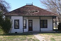
Benjamin F. Billingsley House in Duncan, Arizona
|
||
|
||
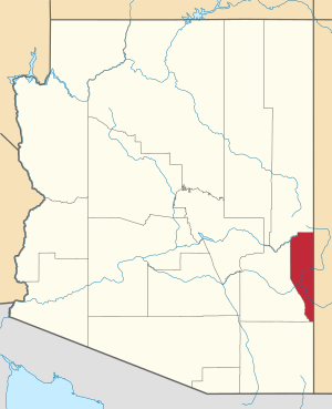
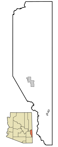
Location within the U.S. state of Arizona
|
||
 Arizona's location within the U.S. |
||
| Country | ||
| State | ||
| Founded | March 10, 1909 | |
| Named for | Mason Greenlee | |
| Seat | Clifton | |
| Largest town | Clifton | |
| Area | ||
| • Total | 1,848 sq mi (4,790 km2) | |
| • Land | 1,843 sq mi (4,770 km2) | |
| • Water | 5.3 sq mi (14 km2) 0.3% | |
| Population
(2020)
|
||
| • Total | 9,563 | |
| • Estimate
(2023)
|
9,369 |
|
| • Density | 5.1748/sq mi (1.9980/km2) | |
| Time zone | UTC−7 (Mountain) | |
| Congressional district | 6th | |
Greenlee County is a county located in the southeastern part of Arizona, a state in the United States. In 2020, about 9,563 people lived here. This makes it Arizona's county with the fewest people. The main town and county seat is Clifton.
The economy of Greenlee County mostly depends on the Morenci Mine. This is the biggest copper mining operation in North America. It is also one of the largest copper mines in the world. As of 2017, the mine employed about 3,300 people. It is owned by a company called Freeport-McMoRan.
Contents
History of Greenlee County
Greenlee County was created in 1909. It was named after Mason Greenlee, who was one of the first people to settle in the Clifton area. It was Arizona's 14th county to be formed.
It was created from a part of Graham County. Graham County did not want this to happen because they would lose a lot of money. Clifton has always been the county seat, which is the main town where the county government is located.
Geography and Nature
Greenlee County covers a total area of about 1,848 square miles. Most of this area, about 1,843 square miles, is land. Only a small part, about 5.3 square miles, is water. This makes Greenlee County the second-smallest county in Arizona by land area.
Neighboring Counties
Greenlee County shares its borders with several other counties:
- Cochise County to the south
- Graham County to the west
- Apache County to the north
- Catron County, New Mexico to the east
- Grant County, New Mexico to the east
- Hidalgo County, New Mexico to the southeast
Protected Natural Areas
Parts of these important natural areas are found in Greenlee County:
- Apache-Sitgreaves National Forest
- Gila Box Riparian National Conservation Area
Main Roads in Greenlee County
Several major highways pass through Greenlee County:
People of Greenlee County
| Historical population | |||
|---|---|---|---|
| Census | Pop. | %± | |
| 1920 | 15,362 | — | |
| 1930 | 9,886 | −35.6% | |
| 1940 | 8,698 | −12.0% | |
| 1950 | 12,805 | 47.2% | |
| 1960 | 11,509 | −10.1% | |
| 1970 | 10,330 | −10.2% | |
| 1980 | 11,406 | 10.4% | |
| 1990 | 8,008 | −29.8% | |
| 2000 | 8,547 | 6.7% | |
| 2010 | 8,437 | −1.3% | |
| 2020 | 9,563 | 13.3% | |
| 2023 (est.) | 9,369 | 11.0% | |
| U.S. Decennial Census 1790–1960 1900–1990 1990–2000 2010–2020 |
|||
In 2010, there were 8,437 people living in Greenlee County. They lived in 3,188 households. The average number of people in each household was about 2.64. The average age of people in the county was 34.8 years old.
About 47.9% of the people living in Greenlee County were of Hispanic or Latino background.
Towns and Communities
Greenlee County has several towns and communities.
Main Towns
Census-Designated Places (CDPs)
These are areas that are like towns but are not officially incorporated.
Other Communities
These are smaller communities that are not officially incorporated.
- Blue
- Apache Grove
- Hannagan Meadows
- Three Way
- Sheldon
- Verde Lee-Loma Linda
- Strayhorse (This is a location along Route 191.)
Old Ghost Towns
Some places in Greenlee County used to be busy towns but are now abandoned. These are called ghost towns.
Schools in Greenlee County
The county has several school districts that serve its communities:
- Blue Elementary School District
- Duncan Unified School District
- Eagle Elementary District
- Morenci Unified School District
See also
 In Spanish: Condado de Greenlee para niños
 | Jackie Robinson |
 | Jack Johnson |
 | Althea Gibson |
 | Arthur Ashe |
 | Muhammad Ali |


