Franklin, Arizona facts for kids
Quick facts for kids
Franklin, Arizona
|
|
|---|---|

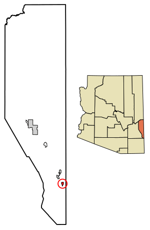
Location of Franklin in Greenlee County, Arizona.
|
|
| Country | United States |
| State | Arizona |
| County | Greenlee |
| Area | |
| • Total | 1.00 sq mi (2.59 km2) |
| • Land | 1.00 sq mi (2.59 km2) |
| • Water | 0.00 sq mi (0.00 km2) |
| Elevation | 3,730 ft (1,140 m) |
| Population
(2020)
|
|
| • Total | 75 |
| • Density | 74.85/sq mi (28.90/km2) |
| Time zone | UTC-7 (MST (no DST)) |
| ZIP code |
85534
|
| Area code(s) | 928 |
| GNIS feature ID | 2582787 |
Franklin is a small community in Greenlee County, Arizona, in the United States. It's called a "census-designated place" because the government counts its population separately. This means it's not an official city or town, but it has its own defined area for counting people. In 2020, about 75 people lived there.
Franklin is located in the southern part of Greenlee County. It's about 3 miles (5 km) west of the border with New Mexico. You can find it along U.S. Route 70. The community is also about 3 miles (5 km) south of Duncan and 32 miles (51 km) south of Clifton.
Kids living in Franklin go to public schools in Duncan. This is similar to how students from the nearby community of York and even Virden, New Mexico attend schools there. Many adults in Franklin work at the Morenci Mine. This large mine is owned by a company called Freeport-McMoRan and is located in Morenci.
People Living in Franklin
The number of people living in Franklin has changed over time. In 2010, the population was 92 people. By 2020, the population was counted as 75 people.
| Historical population | |||
|---|---|---|---|
| Census | Pop. | %± | |
| 2020 | 75 | — | |
| U.S. Decennial Census | |||
See Also
 In Spanish: Franklin (Arizona) para niños
 | Mary Eliza Mahoney |
 | Susie King Taylor |
 | Ida Gray |
 | Eliza Ann Grier |


