
Duncan, Arizona facts for kids
Quick facts for kids
Duncan, Arizona
|
||
|---|---|---|
|
Town
|
||

Bank of Duncan – 1908
|
||
|
||

Location of Duncan in Greenlee County, Arizona
|
||

Duncan, Arizona
Location in the United States
|
||
| Country | United States | |
| State | Arizona | |
| County | Greenlee | |
| Incorporated | 1938 | |
| Government | ||
| • Type | Municipal (Council/Manager Form) | |
| Area | ||
| • Total | 2.15 sq mi (5.57 km2) | |
| • Land | 2.15 sq mi (5.57 km2) | |
| • Water | 0.00 sq mi (0.00 km2) | |
| Elevation | 3,763 ft (1,147 m) | |
| Population
(2020)
|
||
| • Total | 694 | |
| • Density | 322.49/sq mi (124.52/km2) | |
| Time zone | UTC−7 (MST (no DST)) | |
| ZIP code |
85534
|
|
| Area code(s) | 928 | |
| FIPS code | 04-20750 | |
| GNIS feature ID | 2412451 | |

Duncan is a small town in Greenlee County, Arizona, United States. In 2020, about 694 people lived there.
Duncan is located in the Gila River valley. It is about four miles (6 km) west of the Arizona–New Mexico border. The town is on both sides of the Gila River. However, most of the town and its downtown area are on the south side.
Duncan was founded in the mid-1800s. The land became part of the United States through the Mexican Cession and the Gadsden Purchase. Sadly, the town of Duncan has been destroyed twice by floods and once by fire.
Many families in Duncan and the nearby areas work in farming, ranching, and mining. Large copper mines are close by. Smaller towns like Franklin and York in Arizona, and Virden, New Mexico, send their kids to Duncan's public schools.
The areas along the Gila River are famous for ancient artifacts. You can find arrowheads, pottery, and cave paintings. These are from the Anasazi and other old cultures. They lived here until about 1000 to 1290 C.E. when they disappeared. Some Apache Indians lived in the upper Gila River Valley until the 1930s. You can also find items from the camps of Francisco Vázquez de Coronado's expedition.
U.S. Supreme Court Justice Sandra Day O'Connor grew up near Duncan. She was born in El Paso, Texas. Her family's ranch, called Lazy B, was on the border of Arizona and New Mexico. She later wrote a book about her childhood there. It was called Lazy B: Growing up on a Cattle Ranch in the American Southwest.
Contents
Exploring Duncan, Arizona
Getting Around Duncan
U.S. Route 70 goes through downtown Duncan. This road leads west about 39 miles (63 km) to Safford, Arizona. It also goes southeast about 35 miles (56 km) to Lordsburg, New Mexico, and Interstate 10. Arizona State Route 75 goes north from Duncan about 28 miles (45 km) to Clifton.
Duncan's Climate
Duncan has a semi-arid climate. This means it's usually dry. The temperature can change a lot between day and night. This is true for most of the year. During July and August, the weather can be stormy. This is when Duncan gets most of its rain.
It gets cold at night in Duncan. About 131 nights a year have temperatures below 32 °F (0 °C). But only about 8 days a year stay below 50 °F (10 °C). It rarely gets super cold, only about 7 times a year does it drop to 0 °F (−17.8 °C) or lower. The coldest ever was −2 °F (−18.9 °C).
Rainfall is usually light outside of the summer monsoon season. Heavy winter storms are rare. The wettest month on record was August 2014. The most snow ever in Duncan was 15.0 inches or 0.38 metres in January 1949.
| Climate data for Duncan, Arizona (1971–2000; extremes 1901–2001) | |||||||||||||
|---|---|---|---|---|---|---|---|---|---|---|---|---|---|
| Month | Jan | Feb | Mar | Apr | May | Jun | Jul | Aug | Sep | Oct | Nov | Dec | Year |
| Record high °F (°C) | 80 (27) |
85 (29) |
95 (35) |
100 (38) |
108 (42) |
111 (44) |
110 (43) |
107 (42) |
103 (39) |
99 (37) |
87 (31) |
78 (26) |
111 (44) |
| Mean daily maximum °F (°C) | 60.0 (15.6) |
65.0 (18.3) |
71.0 (21.7) |
79.3 (26.3) |
87.7 (30.9) |
96.9 (36.1) |
97.1 (36.2) |
94.4 (34.7) |
90.1 (32.3) |
80.3 (26.8) |
68.2 (20.1) |
59.6 (15.3) |
79.1 (26.2) |
| Mean daily minimum °F (°C) | 23.7 (−4.6) |
26.5 (−3.1) |
31.0 (−0.6) |
35.6 (2.0) |
44.6 (7.0) |
53.6 (12.0) |
63.3 (17.4) |
62.2 (16.8) |
54.2 (12.3) |
41.0 (5.0) |
28.5 (−1.9) |
22.9 (−5.1) |
40.6 (4.8) |
| Record low °F (°C) | −2 (−19) |
−1 (−18) |
9 (−13) |
13 (−11) |
22 (−6) |
32 (0) |
42 (6) |
39 (4) |
34 (1) |
17 (−8) |
6 (−14) |
−2 (−19) |
−2 (−19) |
| Average rainfall inches (mm) | 0.96 (24) |
0.94 (24) |
0.62 (16) |
0.24 (6.1) |
0.38 (9.7) |
0.38 (9.7) |
2.26 (57) |
2.18 (55) |
1.06 (27) |
1.30 (33) |
0.77 (20) |
1.19 (30) |
12.28 (311.5) |
| Average rainy days (≥ 0.01 inch) | 5.0 | 4.5 | 4.1 | 1.5 | 1.9 | 2.2 | 8.5 | 8.5 | 4.6 | 4.4 | 2.9 | 4.7 | 52.8 |
| Source: National Oceanic and Atmospheric Administration | |||||||||||||
People in Duncan
Population Changes Over Time
| Historical population | |||
|---|---|---|---|
| Census | Pop. | %± | |
| 1940 | 887 | — | |
| 1950 | 941 | 6.1% | |
| 1960 | 862 | −8.4% | |
| 1970 | 773 | −10.3% | |
| 1980 | 603 | −22.0% | |
| 1990 | 662 | 9.8% | |
| 2000 | 812 | 22.7% | |
| 2010 | 696 | −14.3% | |
| 2020 | 694 | −0.3% | |
| U.S. Decennial Census | |||
In 2000, there were 812 people living in Duncan. There were 294 households and 206 families. The average household had about 2.76 people. The average family had about 3.33 people.
About 35% of the people were under 18 years old. The median age was 28 years. This means half the people were younger than 28 and half were older.
Transportation in Duncan
Greyhound Lines offers bus service in Duncan. You can take a bus from Phoenix to El Paso, with a stop in Duncan.
Education and Sports
Duncan High School is the local high school. Their mascot is the Wildkat. The school colors are red, grey, and white. Students at Duncan High compete in many sports:
- Fall Sports: Boys' "8 Man" Football, Girls' Volleyball, Boys' and Girls' Cross-country.
- Winter Sports: Boys' and Girls' Basketball.
- Spring Sports: Boys' Baseball, Girls' Softball, Boys' and Girls' Tennis, Boys' and Girls' Golf, Boys' and Girls' Track & Field.
Images for kids
-
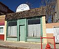
Bank of Duncan – 1908
-
Flag of Duncan, Arizona
-
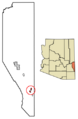
Location of Duncan in Greenlee County, Arizona
See also
 In Spanish: Duncan (Arizona) para niños
