
Remutaka Rail Trail facts for kids
Quick facts for kids Remutaka Rail Trail |
|
|---|---|

Cross Creek station yard, shelter shed, and beginning of the Incline.
|
|
| Length | 22 km (14 mi) |
| Location | |
| Trailheads | Cross Creek Kaitoke Maymorn |
| Use | Cycling Hiking Horse riding |
| Highest point | 1,141 ft (348 m) |
| Difficulty | Grade 2 |
The Remutaka Rail Trail is a cool walking and cycling path in the North Island of New Zealand. Before 2017, it was called the Rimutaka Rail Trail. This trail stretches for about 22 kilometers (13.7 miles) between Maymorn and Cross Creek. It follows the old railway line that used to go over the Remutaka Range, including the famous Rimutaka Incline.
This trail is a super popular spot for outdoor fun! More than 30,000 people walk, run, or bike on it every year. It's part of a bigger network of trails in public parks and nature areas. Sometimes, you might see vehicles from the local council or forestry companies, but the public can only drive a short way from the Kaitoke end to a car park. Horse riders can also use the trail if they have permission.
Contents
Discovering the Trail's Past

After the railway line closed in 1955, the land on the Wellington side of the Remutaka Ranges became owned by the Wellington City and Suburban Water Supply Board. They kept the railway bridges so vehicles could still get to the area for planting trees. From the late 1950s to the early 1970s, many trees were planted. For a long time, it was hard for people to get permission to visit the area just for fun.
The special "Incline" part of the trail became the responsibility of the New Zealand Forest Service. After the railway closed, many old railway buildings were removed from Cross Creek and Summit. Nature slowly started to take over these areas. In 1967, a part of the trail called the Siberia embankment collapsed during a big storm. The Summit tunnel also flooded because of a similar problem.
In 1976, a book called A Line Of Railway came out, and the Fell Engine Museum opened in Featherston. These things made more people interested in the Incline. So, in 1984, the Forest Service made it easier for people to visit Cross Creek. They also drained the Summit Tunnel and cleared the old railway path to make it ready for visitors.
A plan for a walkway between Cross Creek and Kaitoke started in the mid-1980s. This led to the opening of the Rimutaka Rail Trail on November 1, 1987. It was a joint effort by the Wellington Regional Council and the Department of Conservation. They built shelter sheds at Cross Creek and Summit, plus several picnic spots along the way. In 2009, a wall and drains were put in near Price's Tunnel to fix a landslide that happened the year before.
How the Trail is Looked After
The Department of Conservation takes care of the section from Cross Creek to Summit. The Greater Wellington Regional Council looks after the part from Summit to Maymorn. After Kaitoke, the trail goes through Tunnel Gully Reserve.
If you want to walk the whole trail, you can plan your trip to start at Cross Creek and then catch a Wairarapa Connection train at Maymorn station.
Exploring the Cross Creek to Kaitoke Section
This part of the trail is about 18 kilometers (11 miles) long. You can start from either end.
- At Kaitoke, follow the signs along Incline Road from State Highway 2. About 1.25 kilometers (0.78 miles) down this road, you'll find a car park.
- On the Wairarapa side, turn off Western Lake Road to get to the Cross Creek car park. This is about 10 kilometers (6.2 miles) southwest of Featherston. From the Cross Creek car park, it's about a 30-minute walk to the Cross Creek station yard.
- It usually takes about six hours to walk the entire distance between Cross Creek and Kaitoke.
You can park your car at these spots:
- Cross Creek: 41°10′5.59″S 175°14′11.92″E / 41.1682194°S 175.2366444°E
- Kaitoke: 41°5′7.42″S 175°11′4.20″E / 41.0853944°S 175.1845000°E
Here are some cool places to see along this section:
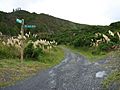
- Cross Creek yard: This is where the old Cross Creek railway station used to be.
- Price’s Tunnel: This tunnel is 98 meters (322 feet) long and has a cool S-shape curve.
- Horseshoe Gully: This is where the Siberia embankment used to be.
- Siberia Tunnel: This tunnel is 108 meters (354 feet) long.
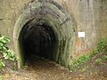
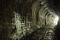
- Summit Tunnel: This is the longest tunnel on the trail, at 584 meters (1,916 feet) long.
- Summit yard: The site of the old Summit railway station.
- Ladle Bend Creek bridge: This bridge is 70 meters (230 feet) long and was fixed up in 2002.
- Pakuratahi bridge: This bridge is 28 meters (92 feet) long. It was rebuilt in 1910 and restored in 2001.
- Rimutaka Tunnel ventilation shaft: This shaft was built to help air flow through the main Rimutaka Tunnel.
- Pakuratahi Tunnel: This tunnel is 73 meters (240 feet) long.
- Munitions Bend bridge: A footbridge was added here in 2003.
Exploring the Kaitoke to Maymorn Section
This part of the trail is about 4.25 kilometers (2.6 miles) long. You can walk or bike it from either end, but it's usually easier to start from the Maymorn end.
- At the end of Plateau Road, there's a car park for people visiting the Tunnel Gully reserve. From there, you can get onto the rail trail.
- Near Maymorn railway station and its car park, at the intersection of Maymorn Road and Parkes Line Road, there's an access road that connects to the rail trail above the Rimutaka Tunnel.
- From the Kaitoke end, you can get to the trail from some forestry roads or from a forestry road that connects to Kaitoke Loop Road.
You can find parking near the Maymorn end of this section:
- Plateau Road: 41°6′14.74″S 175°9′13.43″E / 41.1040944°S 175.1537306°E
- Maymorn railway station
There are no car parks at the Kaitoke end of this section.
The main interesting spot along this part of the trail is:
- Mangaroa Tunnel: This tunnel is 152 meters (499 feet) long.
What's Next for the Trail?
In 2011, a group called the Rimutaka Incline Railway Heritage Trust suggested rebuilding the railway line over the Remutaka Range. However, they decided not to go ahead with this plan in February 2012.
Their idea was to use the same path that the rail trail uses now to lay new railway tracks in the future. The trust has been working on the first part of their plan, which involves building things at Maymorn. Later on, they planned to create new places for people who currently use the rail trail before any tracks were laid.
Gallery
-
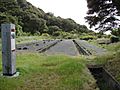
Foundations of the Cross Creek locomotive shed
-
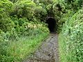
Southern portal of Price's Tunnel
-
Northern portal of Price's Tunnel
-
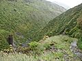
Horseshoe Gully and Siberia embankment washout
-
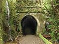
Southern portal of Summit Tunnel
-
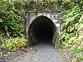
Northern portal of Summit Tunnel
-
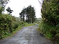
Cutting and southern approach to Summit yard from the tunnel
-
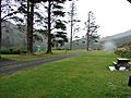
Summit yard
-
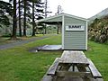
Summit shelter shed
-
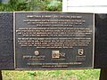
Institute of Professional Engineers New Zealand plaque
-
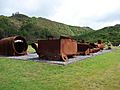
Locomotive remnants in Summit yards
-
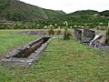
Ash pit in Summit yard
-
Northern approach to Summit yard


Images for kids
-
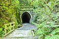
Bridge and southern portal of Summit Tunnel
-
Siberia Tunnel
-
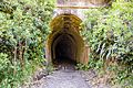
Siberia Tunnel


