
Porirua facts for kids
Quick facts for kids
Porirua
Pari-ā-Rua
|
|||
|---|---|---|---|
|
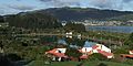
Top: Panoramic view of Porirua from Tītahi Bay to Ranui Heights. Bottom: Aerial view of Porirua Town Centre and Karehana Bay at sunset
|
|||
|
|||
| Motto(s): | |||
 |
|||
| Country | New Zealand | ||
| Region | Wellington | ||
| Wards |
|
||
| Electorates | Mana (general) Te Tai Hauāuru (Māori) |
||
| Government | |||
| • Type | City council | ||
| Area | |||
| • Territorial | 174.80 km2 (67.49 sq mi) | ||
| • Urban | 61.19 km2 (23.63 sq mi) | ||
| • Rural | 113.82 km2 (43.95 sq mi) | ||
| Population
(June 2023)
|
|||
| • Territorial | 62,400 | ||
| • Density | 356.98/km2 (924.6/sq mi) | ||
| • Urban | 60,900 | ||
| • Urban density | 995.3/km2 (2,577.7/sq mi) | ||


Porirua (also known as Māori: Pari-ā-Rua) is a city in the Wellington Region of New Zealand. It is one of the four cities that make up the wider Wellington area. The name 'Porirua' comes from the Māori words 'Pari-rua', which means "the tide sweeping up both reaches". This refers to the two arms of the Porirua Harbour that the city almost completely surrounds.
As of 2023, Porirua has about 62,400 people. It is a very diverse city. About 26.5% of the people are Pasifika and 23.0% are Māori.
Contents
- What Does the Name Porirua Mean?
- A Brief History of Porirua
- Porirua's Population and People
- City Symbols: Coat of Arms and Flag
- Exploring Porirua's Suburbs
- Shopping and Commerce
- Getting Around Porirua
- Education in Porirua
- Arts and Culture
- Sports and Fun Activities
- Famous People from Porirua
- Porirua's Climate
- Sister and Friendly Cities
- Images for kids
- See also
What Does the Name Porirua Mean?
The name "Porirua" comes from the Māori words pari-rua, meaning "two tides". This name describes the two parts of the Porirua Harbour. In the 1800s, the name was used for a large land area. This area stretched from Kaiwharawhara in Wellington north to the Porirua Harbour.
Today, a road called "Old Porirua Road" still exists. It climbs the hill from Kaiwharawhara towards areas like Ngaio and Tawa.
A Brief History of Porirua
Local stories say that Kupe, a famous explorer, was the first visitor to this area. He gave names to important places, like Mana Island. It is also said that Kupe left his anchor stone, Te Punga o Matahouroa, at Whitireia. This stone is now kept at Te Papa Tongarewa museum.
People have lived in Porirua since at least 1450. This was during the "moa hunter" time of Māori history. The forests, sea, and swamps provided plenty of food and materials. Over time, different Māori tribes lived in the Porirua area. These included Ngāti Tara and Ngāti Ira.
The Ngāti Toa people moved south from Kawhia in the 1820s. They took control of the Porirua coast. By the 1840s, they had built 12 pā (fortified villages). Two of these, Takapūwāhia and Hongoeka, are still home to marae (Māori meeting grounds) today.
European Settlement and Land Sales
In the late 1830s, European settlers became interested in the Porirua area. In 1839, the New Zealand Company claimed to have bought the entire southern North Island from Ngāti Toa. However, after the Treaty of Waitangi was signed, an investigation found that most of this sale, including Porirua, was not valid.
Tensions grew between Māori and European settlers. In July 1846, the Ngāti Toa chief Te Rauparaha was captured by British troops. Soon after, the Hutt Valley campaign led to chief Te Rangihaeata moving to Poroutawhao. In April 1847, eight other chiefs signed a deal to sell 69,000 acres for £2,000. This was almost the entire area from Mākara to Paekākāriki. Three areas, totaling 10,000 acres, were kept for Ngāti Toa. Ngāti Toa believe this deal was made under pressure, hoping for Te Rauparaha's release.
In the 1800s, a small European settlement grew. This was partly because a ferry was needed to cross the harbour.
Growth and Development
In the late 1800s, the Porirua Lunatic Asylum was built. Later, it became Porirua Mental Hospital.
In the late 1940s, plans were made for Porirua to become a "satellite city" of Wellington. This meant building many state houses. To support this, better rail and road links to Wellington were needed. These transport improvements helped Porirua grow. People could now live in Porirua and work in Wellington. Day trips to beaches like Paremata and Plimmerton also became easier.
Since the 1940s, Porirua has grown a lot. Its population is now close to 57,000. State housing is no longer the main type of home. The city also grew in size in 1973 and 1988.
New Zealand's first McDonald's restaurant opened in Porirua on June 7, 1976. The original restaurant closed in 2009 and moved to a new location.
Local Industries
Porirua has many industrial areas, mostly west of the city centre.
- In the 1960s, companies like Kodak and UEB Industries opened factories.
- In the 1970s, Ashley Wallpapers and Todd Motors (later Mitsubishi) moved to Porirua.
- Todd Motors built cars and employed 1500 people at its peak. The factory closed in 1998.
- Hills Hats, a hat-making company, moved to Porirua in the 1950s. It exported hats to many countries. The company moved to Petone in 2003.
- Bonds Hosiery (later Hilton Bonds) made socks and stockings. The factory closed in 2001.
- Whittaker's chocolate factory moved from Wellington to Porirua in 1969. It still makes chocolate there today.
Rail Transport History
The railway through Porirua, part of the Kapiti Line, helped the city grow.
- In 1885, a railway line opened from Wellington to Porirua. This line later became part of the North Island Main Trunk railway.
- The railway made it easier for people to travel between Wellington and Porirua. It also brought goods like timber for building houses.
- In 1937, a new railway section called the Tawa Flat deviation opened. This cut travel time from Wellington to Porirua by 15 minutes.
- In 1940, the line from Wellington to Paekākāriki was electrified. This meant electric trains could run, which were faster and cleaner.
- Electric multiple unit trains (like the DM/D) started running to Porirua in 1949. These trains made services more frequent and faster.
- More tracks were added over the years, making train services even better.
- In 1960, the track from Porirua to Mana was straightened. This involved reclaiming land from the harbour and creating lagoons, like Aotea Lagoon.
- Today, electric trains run frequently between Wellington and Porirua. Travel time for stopping trains is about 21 minutes.
Road Transport History
Road improvements also helped connect Porirua to Wellington.
- The Johnsonville–Porirua Motorway (now part of State Highway 59) links the two cities.
- In 1940, the Centennial Highway opened a four-lane road in Ngauranga Gorge.
- In the 1950s, the Johnsonville–Porirua Motorway was built. This made travel much faster by avoiding narrow, winding roads.
- In 1936, a road bridge opened across the Pauatahanui Inlet. This saved a long journey around the inlet. A second bridge was built in 2004.
- In the late 1960s, more land was reclaimed for a four-lane expressway next to the railway. This opened in the early 1970s.
- In 1989, a new interchange was built in Porirua to improve traffic flow.
- The Transmission Gully Motorway was built between 2014 and 2021. This new motorway bypasses Porirua to the east. On December 7, 2021, the main highway (SH 1) was moved to this new motorway. The old route through Porirua became State Highway 59.
Porirua's Population and People
Porirua City covers about 174.80 square kilometers. Its estimated population is 62,400 people.
| Historical population for the territorial area | ||
|---|---|---|
| Year | Pop. | ±% p.a. |
| 2006 | 48,546 | — |
| 2013 | 51,717 | +0.91% |
| 2018 | 56,559 | +1.81% |
| 2023 | 59,445 | +1.00% |
In the 2023 New Zealand census, Porirua City had 59,445 people. This was an increase of 5.1% since the 2018 census. The median age was 35.9 years. About 22.1% of people were under 15 years old.
| Nationality | Population (2018) |
|---|---|
| Samoa | 2,673 |
| England | 2,514 |
| South Africa | 870 |
| Australia | 783 |
| India | 627 |
| Fiji | 546 |
| China | 492 |
| Philippines | 378 |
| Scotland | 288 |
| United States | 249 |
People could choose more than one ethnicity. The results showed:
- 60.1% European (Pākehā)
- 23.0% Māori
- 26.5% Pasifika
- 11.5% Asian
- 1.6% Middle Eastern, Latin American, and African New Zealanders (MELAA)
- 1.8% other ethnicities
English was spoken by 94.9% of people. Māori language was spoken by 5.8%, and Samoan by 8.8%.
Many people in Porirua identify as Christian (38.6%). About 47.4% said they had no religion.
The median income in Porirua was $47,200. This is higher than the national median of $41,500. Most people (54.8%) aged 15 or older were employed full-time.

| Name | Area (km2) |
Population | Density (per km2) |
Dwellings | Median age | Median income |
|---|---|---|---|---|---|---|
| Pāuatahanui General Ward | 133.45 | 24,000 | 180 | 8,469 | 40.5 years | $60,800 |
| Onepoto General Ward | 41.35 | 35,445 | 857 | 10,662 | 33.2 years | $39,200 |
| New Zealand | 38.1 years | $41,500 |
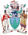
City Symbols: Coat of Arms and Flag
Porirua's Coat of Arms
 |
|
Porirua's Flag
Porirua City first had a flag in 1978. A student from Papakowhai School designed it. This flag had a yellow cross on a green background with the city's coat of arms. After local government changes in 1989, this flag was no longer used.
The current flag of Porirua was adopted on September 30, 1998. It has blue stripes and a green shape. These parts represent the city's harbour and land. The flag can also include the coat of arms.
Exploring Porirua's Suburbs
Porirua is built around the arms of the Porirua Harbour. It also stretches along the coast facing Cook Strait. Many parts of Porirua are near the water. Suburbs like Camborne, Karehana Bay, and Tītahi Bay have direct access to coastal parks. Other suburbs, like Aotea and Ascot Park, have great views of the harbour.
The city centre was partly built on land reclaimed from the harbour.
Here are some of Porirua's suburbs, grouped by council ward:
Onepoto Ward
- Rangituhi / Colonial Knob
- Elsdon
- Kenepuru – an industrial area
- Mana Island
- Onepoto - part of Tītahi Bay
- Porirua City Centre
- Takapūwāhia – a Ngāti Toa settlement
- Tītahi Bay – where golfer Michael Campbell grew up
- Aotea
- Ascot Park
- Cannons Creek
- Rānui
- Waitangirua
Pāuatahanui Ward
- Camborne
- Hongoeka – a Ngāti Toa settlement
- Judgeford – a rural area
- Karehana Bay
- Mana
- Paekākāriki Hill
- Papakōwhai – known for kōwhai trees
- Paremata
- Pāuatahanui
- Plimmerton
- Pukerua Bay – where filmmaker Peter Jackson grew up
- Whitby – street names honor James Cook
Shopping and Commerce
North City Shopping Centre is Porirua's biggest indoor mall. It opened in 1990 and has over 80 stores. It was the first place in Wellington to have a Kmart store. The Megacentre shopping complex opened in 1999.
Before these malls, shopping was mainly in the Cobham Court area. In 1996, large white canopies were put up over Cobham Court to make it nicer. These canopies were removed in 2015 as part of a city improvement project. After they were removed, crime in the area reportedly decreased.
Getting Around Porirua
Roads
State Highway 59 is the main road through Porirua. It connects the city to Wellington in the south and the Kāpiti Coast in the north. This highway includes the Johnsonville–Porirua motorway.
State Highway 1 now goes around Porirua as the Transmission Gully Motorway. There are roads that link this motorway to areas like Kenepuru and Whitby.
State Highway 58 connects Paremata to the Hutt Valley in the east.
The Ara Harakeke is a pathway for walking and cycling. It runs next to SH 59 and the Taupō Swamp. The first part of this path opened in 2002.
Trains
The North Island Main Trunk railway line runs through Porirua. There are six train stations within the city. These include Kenepuru, Porirua, Paremata, Mana, Plimmerton, and Pukerua Bay.
Kapiti Line suburban trains run between Wellington and Waikanae. During the day, trains usually run every twenty minutes. The Northern Explorer long-distance train also passes through Porirua.
Airports and Ferries
The closest airports are Wellington Airport to the south and Paraparaumu Airport to the north.
Ferry services used to run between Paremata and Picton. However, they couldn't compete with services from Wellington.
Education in Porirua
.jpg)
The Royal New Zealand Police College is in Papakōwhai. This is where all new police recruits in New Zealand get their training.
Porirua has several high schools:
- Aotea College is near the northern suburbs.
- Mana College and Bishop Viard College are closer to the city centre.
- Porirua College is to the east.
For higher education, Whitireia Polytechnic has its main campus north of the city centre.
Arts and Culture
You can learn about local culture, history, and artists at the Pātaka Museum of Arts & Cultures. The public library is also located there.
The indie rock radio station andHow.FM broadcasts locally on 107.5 FM from the suburb of Papakōwhai.
Sports and Fun Activities
Te Rauparaha Arena is a large place for sports and events. It is next to the Pātaka Museum. The Porirua Skatepark, designed by Moses Viliamu, is also nearby. Aotea Lagoon is a popular spot for recreation on the harbour.
Watersports are very popular in Porirua. There's a large marina in Mana. You can find clubs for Sea Scouts, yachting, power-boating, rowing, and water-skiing. The harbour entrance is great for experienced windsurfers and kitesurfers. Beginners can learn in the calm, shallow waters of the Pauatahanui arm of the harbour.
In the past, Porirua even held horse races on the harbour's southern beach!
Porirua is home to strong rugby clubs like Northern United RFC and Paremata-Plimmerton RFC. The city also has a successful football team, Western Suburbs FC. They are known for producing many talented players.
In 2010, Porirua hosted the Oceania Handball Championship. An Adrenalin Forest adventure park also opened in Porirua in 2010. Here, visitors can climb rope bridges and swings high up in the trees.
Famous People from Porirua
Many notable people have lived in Porirua.
Notable Councillors
- Whitford Brown (first mayor)
- Ken Douglas (trade unionist)
- Ken Gray (All Black rugby player)
- Gary McCormick (media personality)
- Helen Smith (first member of the Values Party elected to local government)
- Duncan Paia'aua (Rugby Union Player)
- Tutu Wineera (kaumatua of the Ngāti Toa iwi)
Other Prominent Residents
- Aaradhna (R&B singer)
- Alistair Campbell, poet
- Michael Campbell (golfer)
- Jerry Collins (All Black rugby player)
- Sophie Devine (cricketer)
- Tamati Ellison (All Black rugby player)
- Craig Garner (cricketer)
- Vince Mellars (rugby league player)
- Frank Moore (politician)
- Heremaia Ngata (All White football player)
- TJ Perenara (All Black rugby player)
- Paul Rauhihi (rugby league player)
- Mike Riddell (writer)
- Emmett Skilton (actor)
- PJ Solomon (rugby player for Scotland)
- Rodney So'oialo (All Black rugby player)
- Ramon Te Wake (presenter and singer-songwriter)
- Renouf To'omaga (rugby league player)
- Ela To'omaga-Kaikilekofe (visual artist)
Porirua's Climate
| Climate data for Cannons Creek, Porirua (1971–2000) | |||||||||||||
|---|---|---|---|---|---|---|---|---|---|---|---|---|---|
| Month | Jan | Feb | Mar | Apr | May | Jun | Jul | Aug | Sep | Oct | Nov | Dec | Year |
| Mean daily maximum °C (°F) | 20.7 (69.3) |
20.9 (69.6) |
19.7 (67.5) |
17.3 (63.1) |
14.9 (58.8) |
12.8 (55.0) |
12.2 (54.0) |
12.7 (54.9) |
13.8 (56.8) |
15.4 (59.7) |
17.0 (62.6) |
18.9 (66.0) |
16.4 (61.4) |
| Daily mean °C (°F) | 16.9 (62.4) |
17.0 (62.6) |
16.0 (60.8) |
13.8 (56.8) |
11.5 (52.7) |
9.6 (49.3) |
9.0 (48.2) |
9.4 (48.9) |
10.5 (50.9) |
12.0 (53.6) |
13.5 (56.3) |
15.3 (59.5) |
12.9 (55.2) |
| Mean daily minimum °C (°F) | 13.0 (55.4) |
13.0 (55.4) |
12.2 (54.0) |
10.3 (50.5) |
8.0 (46.4) |
6.5 (43.7) |
5.7 (42.3) |
6.0 (42.8) |
7.2 (45.0) |
8.6 (47.5) |
10.0 (50.0) |
11.7 (53.1) |
9.4 (48.8) |
| Average rainfall mm (inches) | 88 (3.5) |
65 (2.6) |
95 (3.7) |
95 (3.7) |
124 (4.9) |
137 (5.4) |
131 (5.2) |
120 (4.7) |
100 (3.9) |
93 (3.7) |
79 (3.1) |
83 (3.3) |
1,210 (47.7) |
| Source: NIWA | |||||||||||||
Sister and Friendly Cities
Porirua has special relationships with other cities around the world.
Sister Cities
- Blacktown, Australia
- Nishio, Japan
Friendly Cities
Twin City
- Whitby, United Kingdom
Images for kids
-
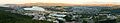
Panoramic view of Porirua from Tītahi Bay to Ranui Heights
-
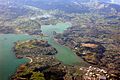
Aerial view of Porirua Town Centre
-
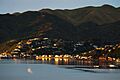
Karehana Bay at sunset
-
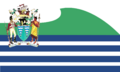
Present flag with coat of arms
-
Porirua's Coat of Arms
-
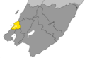
Map showing Porirua City within the Wellington Region
-
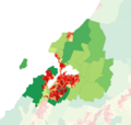
Population density in the 2023 census
-
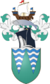
Porirua Coat of Arms shield and crest
-
Police College chalets above the Aotea Lagoon
See also
 In Spanish: Porirua para niños
