
Camborne, New Zealand facts for kids
Quick facts for kids Camborne |
|
|---|---|
 |
|
| Basic information | |
| Local authority | Porirua City |
| Electoral ward |
|
| Land area | 84 ha (0.32 sq mi)* |
| Population | 2,080 (June 2023) |
|
|
||
Camborne, New Zealand is a cool suburb in Porirua, located both on a hilltop and by the sea. It's about 0.84 square kilometers in size. Many homes in Camborne have awesome views of Porirua Harbour, nearby hills, the ocean, and even Mana Island!
Contents
History of Camborne
Camborne was built up over 35 years, starting in the 1960s. It was named after a town called Camborne, Cornwall in England. Because of this, many of the street names in Camborne are also from Cornwall. However, the main street, Pope Street, is named after William George Pope, who was a respected person from the nearby suburb of Plimmerton.
The Paremata Residents Association is a group that includes people from Camborne. They work together for the local community.
Who Lives in Camborne?
Camborne is home to about 2,013 people, based on the 2018 New Zealand census. This means the population grew by 5.5% since 2013! The average age of people living here is about 40.5 years old.
- About 21.6% of the people are under 15 years old.
- Most people (51.0%) are between 30 and 64 years old.
Most people in Camborne are of European descent (89.4%). There are also people from other groups, including Māori (9.5%), Pasifika (2.8%), and Asian (6.7%). About 21% of the people living in Camborne were born outside New Zealand.
When it comes to beliefs, about 55.1% of people said they had no religion. Many others were Christian (34.4%).
Many adults in Camborne have a university degree (34.6%). The average income in Camborne is higher than the national average, which means many people earn good salaries. Most adults (59.1%) work full-time.
Economy and Shopping
Camborne itself doesn't have its own shops. However, it's super close to the shopping areas in Plimmerton and Mana. If you need more options, the bigger city centers of Porirua and Wellington are just a drive away.
People in Camborne work in many different jobs:
- 11.5% work in construction (building things).
- 9.0% work in education (like teachers).
- 8.7% work in healthcare (like doctors and nurses).
Getting Around Camborne
In 2018, most people who traveled to work from Camborne drove a car (71.0%). Some people also rode in a car with others (11.3%). A smaller number of people used bikes (2.7%) or walked (2.7%).
There isn't a public bus service for everyone in Camborne, except for school buses that take students to local schools like Plimmerton School and Aotea College. The closest public transport options are the Mana and Plimmerton train stations.
Images for kids
-
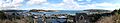
This picture shows the wide views of Porirua Harbour and the sea from Camborne. You can see Mana Island in the middle and Plimmerton to the right. The Pauatahaunui Inlet is on the left.
