
Porirua Harbour facts for kids

Te Awarua-o-Porirua Harbour, also known as Porirua Harbour, is a natural bay on the southwest coast of New Zealand's North Island. The city of Porirua surrounds this harbour. Porirua is one of the four main cities in the Wellington area. The city centre is located just south of the harbour.
The harbour has a narrow entrance, only a few hundred metres wide, near the suburb of Plimmerton. Once inside, the harbour opens up into two main parts, like arms. The Onepoto Arm is to the south, and the Pauatahanui Arm is to the north-east. Both arms are about three kilometres long.
How the Harbour Changed Over Time
The Porirua Harbour has changed quite a bit over the years. Part of the harbour was filled in to build a raised road for the North Island Main Trunk railway line. This happened when the railway section between Porirua and Mana was made straighter and had a second track added. The new part of the Kapiti Line opened on November 7, 1960. Because of these changes, a new Paremata Railway Station and a bridge over the entrance to the Pauatahanui Inlet were needed.
The railway line no longer followed the curves of the shoreline bays north of Porirua. This created three shallow lagoons on the land side of the new railway path. In the 1970s, State Highway 1 was also straightened to run next to the railway line. This meant these lagoons were partly filled in even more. One of these lagoons, Aotea Lagoon, was later turned into a fun area for people to visit.
The official name of the harbour was changed to Te Awarua-o-Porirua Harbour in August 2014.

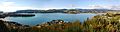
Pauatahanui Inlet: A Special Wetland
The Pauatahanui Inlet is one of the arms of the harbour. It stretches eastward towards the small settlement of Pauatahanui. This area is very important because it has a large wetland where the Pauatahanui Stream flows into the inlet. This wetland is the biggest remaining estuary wetland in the lower North Island.
To protect this special environment and help damaged areas recover, the Pauatahanui Wildlife Reserve was created in the 1980s. It's a great place for wildlife, especially birds, and helps keep the harbour healthy.

Images for kids
-
The Pauatahanui arm of the Porirua Harbour with the entrance at the extreme left and Pauatahanui at the extreme right
