
State Highway 1 (New Zealand) facts for kids
Quick facts for kids
|
||||
|---|---|---|---|---|
 |
||||
| Route information | ||||
| Maintained by NZ Transport Agency | ||||
| Length | 2,033 km (1,263 mi) | |||
| Tourist routes |
|
|||
| North Island (SH 1N) | ||||
| Length | 1,081 km (672 mi) | |||
| North end | Cape Reinga / Te Rerenga Wairua | |||
| Major junctions |
||||
| South end | ||||
| South Island (SH 1S) | ||||
| Length | 952 km (592 mi) | |||
| North end | ||||
| Major junctions |
|
|||
| South end | Bluff (Stirling Point) | |||
| Location | ||||
| Primary destinations: |
||||
| Highway system | ||||
|
||||

State Highway 1 (SH 1) is the longest and most important road in New Zealand. It runs all the way through both of New Zealand's main islands. On maps, you'll see it as SH 1, and on road signs, it's a white number 1 on a red shield. Officially, it's called SH 1N in the North Island and SH 1S in the South Island.
SH 1 is about 2,006 kilometers (1,246 miles) long. About 1,074 km (667 miles) of it is in the North Island, and 932 km (579 miles) is in the South Island. Most of SH 1 is a two-lane road. This means it has one lane going each way. It has intersections where roads cross at the same level, and driveways for properties. These parts of the highway often have extra lanes for passing slower vehicles. About 315 km (196 miles) of SH 1 is a faster, multi-lane road called a motorway or expressway.
Contents
Exploring the Route
North Island (SH 1N)
SH 1N begins at Cape Reinga, which is at the very top of the Aupōuri Peninsula. Since 2010, the entire road is paved. From Waitiki Landing, south of Cape Reinga, SH 1 travels along the eastern side of the peninsula to Kaitaia, New Zealand's northernmost town. Then, it goes through the Mangamuka Gorge before heading southeast across the Northland Peninsula to Kawakawa. In Kawakawa, the road shares space with a vintage railway track! After that, it continues south to Whangārei, the biggest city in Northland.
SH 1 then goes around the southwestern part of Whangārei Harbour. It gets close to the coast at Ruakākā before winding through the Brynderwyn Hills. Then, it approaches the Kaipara Harbour. The highway enters the Auckland Region and passes through Wellsford and Warkworth.
Just north of Warkworth, the road becomes a four-lane motorway called Ara Tūhono. This section, from Puhoi to Warkworth, opened in June 2023. In the Moir Hill area, it even widens to six lanes on uphill parts to help traffic flow.
Near Puhoi, SH 1 becomes the Auckland Northern Motorway. A part of this motorway, from Warkworth to Orewa, is a toll road, meaning you pay to use it. After Orewa, it's free to use. The motorway crosses farmlands to Auckland's North Shore. It goes through suburbs to the Waitematā Harbour, which it crosses on the famous Auckland Harbour Bridge. After the bridge, it reaches the Central Motorway Junction, also known as "Spaghetti Junction" because of its many ramps. Here, SH 1 becomes the Auckland Southern Motorway. It travels southeast across the Auckland isthmus, through Manukau and Papakura, to the top of the Bombay Hills.
At Bombay, SH 1 changes into the Waikato Expressway, which is a four-lane, divided highway. This expressway takes the highway down the Bombay Hills to Mercer, where SH 1 meets the Waikato River. The road generally follows this river for about 220 km (137 miles). The Waikato Expressway goes around Hamilton city to the east and then bypasses Cambridge to the north. After Cambridge, it goes back to being a single carriageway. The highway continues east to Tīrau, then turns south through Putāruru and Tokoroa, passing through areas with many pine tree farms.
At Wairakei, SH 1 takes an eastern route to go around Taupō and meets the Lake Taupō shoreline south of the town, near the airport. SH 1 follows the eastern shore of the lake for about 50 km (31 miles) to Tūrangi, at the lake's southern end.
Turning south again, SH 1 leaves Tūrangi and climbs onto the North Island Volcanic Plateau. It passes near the Tongariro National Park and into the Rangipo Desert. Here, you can see the volcanoes of Ruapehu, Ngauruhoe, and Tongariro. The road between Rangipo and Waiouru is often called the Desert Road. SH 1 enters the Manawatū-Whanganui Region and goes down through an army training area to the end of the Desert Road at Waiouru.
From Waiouru, the highway follows rivers through Taihape to meet the main Rangitikei River at Utiku. It then follows the river's western bank through Ohingaiti and Hunterville to Bulls. At Bulls, SH 1 turns southeast to cross the river, then turns southwest again about 5 km (3 miles) down the road at Sanson. SH 1 crosses the flat Manawatū Plains, passing about 20 km (12 miles) west of Palmerston North city. It goes through Foxton before reaching the end of the plain at Levin.
From Levin, SH 1 follows the narrowing western coastal plain south. The highway enters the Wellington Region about 15 km (9 miles) south of Levin. Just north of Ōtaki, it widens into the Kāpiti Expressway, a four-lane divided highway with no cross-traffic. This expressway goes around the towns of Waikanae, Paraparaumu, and Raumati, before reaching the end of the coastal plain at Mackays Crossing. It then becomes the Transmission Gully Motorway. This motorway climbs steeply through hills to the Wainui Saddle, then goes down through its valley to Pāuatahanui. It bypasses Porirua to the east before reaching the northern suburbs of Wellington, New Zealand's capital city.
_Gorge_Road,_January_1912_ATLIB_337837.png)
Right after entering Wellington city in the suburb of Linden, the Transmission Gully Motorway ends. SH 1 then joins the Johnsonville-Porirua Motorway. This motorway gradually climbs through Tawa before reaching Johnsonville. Here, the motorway ends, and SH 1 becomes a six-lane main road that goes steeply down through the Ngauranga Gorge to the Ngauranga Interchange, right on the shore of Wellington Harbour.
At Ngauranga, SH 1 becomes the Wellington Urban Motorway. It follows the harbor shore, then passes west of the city center. The motorway finishes at Te Aro. From there, a system of one-way streets takes traffic to the Basin Reserve. Northbound traffic uses the Wellington Inner City Bypass (opened in 2007), while southbound traffic uses Vivian Street. From the Basin Reserve, SH 1 goes through the Mount Victoria Tunnel to Wellington's eastern suburbs and Wellington International Airport. SH 1 ends at a roundabout at the airport entrance.
South Island (SH 1S)
The South Island part of SH 1 starts in Picton, right next to the railway station. Leaving Picton, SH 1 climbs steeply over the Elevation saddle and then goes down into the Tuamarina River valley. It follows this river and crosses the Wairau Plain before reaching Blenheim. SH 1 then goes through Weld Pass and Dashwood Pass to enter the Awatere Valley. It continues south, passing Lake Grassmere. From the small town of Ward, the highway heads to the coast and follows it to Kaikōura. After Kaikōura, it turns inland, winding through the Hundalee Ranges before reaching the northern end of the Canterbury Plains.
A section of the highway north of Kaikōura was closed for over a year (from November 2016 to December 2017) because of damage from the 2016 Kaikōura earthquake.
SH 1 passes through Amberley and Woodend before becoming the Christchurch Northern Motorway. It goes around Kaiapoi to the west. At The Groynes, west of Belfast, the motorway becomes a four-lane divided road. SH 1 continues around the northwestern edge of Christchurch, passing just east of Christchurch International Airport. At Hornby, the highway turns southwest, narrows to a two-lane road, and goes through Templeton. It then joins the Christchurch Southern Motorway, which is an expressway, until it gets close to Rolleston.
South of Rolleston, SH 1 becomes very straight as it crosses the wide, flat Canterbury plains. It crosses New Zealand's longest road bridge at Rakaia before reaching Ashburton. Then, it turns back towards the coast, reaching it at Timaru. Between Ashburton and Timaru, it crosses Rangitata Island in the Rangitata River.
South of Timaru, the road goes through gentle hills, staying close to the coast but mostly out of sight. The road briefly turns inland, bypassing Waimate as it reaches the plains around the mouth of the Waitaki River. It crosses this river to enter Otago. It passes through Oamaru, then turns inland briefly, crossing rolling hills before reaching the coast again at Moeraki. From here, the road stays very close to the ocean along Katiki Beach. The highway turns inland at Shag Point, passing through Palmerston and Waikouaiti.
South of Waikouaiti, the road becomes steep again, climbing sharply over the Kilmog hill before dropping down to the coast at Blueskin Bay. Then, it climbs again via the Dunedin-Waitati Highway to the northern edge of Dunedin. From here, it goes down a steep, winding part of Pine Hill Road through Pine Hill, before passing the University of Otago and going through the city center. For much of its route through central Dunedin, the highway is split into two separate one-way roads for northbound and southbound traffic. At the southern end of central Dunedin, the highway becomes the Caversham By-pass, which climbs along the Caversham Valley before becoming a motorway again at Lookout Point.
The four-lane motorway (Dunedin Southern Motorway) runs through Dunedin's southern suburbs until it meets SH 87 at Mosgiel. SH 1 then heads southwest across the Taieri Plains. The area between the Taieri and Waipori Rivers can flood, so the highway crosses this on a large raised road called the flood-free highway. SH 1 continues through gentle hills and along the shore of Lake Waihola, then crosses the Tokomairiro Plains into Milton. South of Milton is a major intersection with SH 8 at Clarksville Junction. SH 1 continues to cross rolling hills to reach Balclutha.
From Balclutha, the highway turns west, briefly heading north inland to avoid the rough hills of The Catlins. It passes through the small town of Clinton before reaching the larger town of Gore. Because of the names of these two towns, this part of the highway was once called "The Presidential Highway." At Gore, the highway crosses the Mataura River; from here, the road turns south to generally follow the river. The highway passes through Mataura before turning west at Edendale. Many travelers choose to use SH 93 at Clinton, as it makes the journey between Clinton and Mataura about 10 km (6 miles) shorter and avoids Gore. Over its last section, the road turns southwest before reaching the city of Invercargill. In central Invercargill, it meets the southern end of SH 6 and turns directly south, going around the New River estuary and Bluff Harbour. It passes through the small town of Bluff before ending at Stirling Point, about a kilometer south of Bluff. A special signpost at Stirling Point shows distances to major cities around the world and to the start of the highway in Picton.
Spur Sections
SH 1 has two shorter roads that branch off it, both near Hamilton:
- SH 1B runs from SH 1N at Taupiri to SH 1N at Cambridge. It acts as an eastern bypass for Hamilton. This highway is about 42 km (26 miles) long. It uses many roads that were previously managed by the Waikato District Council. Part of SH 1B also shares the road with SH 26. Because new parts of the Waikato Expressway have opened, SH 1B is now shorter at both its northern and southern ends. SH 1B is planned to be given back to the Waikato District Council.
- SH 1C runs from SH 1N at Horsham Downs to SH 1N at Tamahere. This used to be the main route of SH 1 through Hamilton before the Hamilton section of the Waikato Expressway opened in July 2022. This route is about 24 km (15 miles) long.
Road Conditions
SH 1 has different types of road conditions. For most of its length, it's a two-lane road with intersections at the same level as the highway. In rural areas, it's often paved with chipseal, and in cities or busy areas, it uses asphalt. These sections often have passing lanes, which are extra lanes that let drivers safely overtake slower vehicles. Some parts of the road are quite steep. Most steep sections have passing lanes for uphill traffic and special lanes or stopping areas for heavy vehicles going downhill, so they can pull over and let other cars pass.
The New Zealand Transport Agency (Waka Kotahi) considers most of State Highway 1 a very important national road. Some parts, like between Kawakawa and Whangārei, and south of Mosgiel, are seen as important regional roads. The sections between Wellsford and Wairakei, and between Ōhau and Wellington Airport, are very busy roads. The busiest part of the road is in Auckland, between the Central Motorway Junction and the Newmarket Viaduct. More than 200,000 vehicles use this 3 km (2 mile) section every day.
In September 2010, the NZTA replaced the last three "fords" (places where a road crosses a shallow river) on SH 1S near Kaikōura. These fords were usually dry, but about 28 days a year, traffic had to take a detour because of high water, causing delays on this important freight route. The old detour bridges were getting old, so NZTA replaced the fords with culverts (tunnels for water under the road).
Route Changes and Upgrades
Motorway and Expressway Upgrades
Many new motorways and expressways have changed where State Highway 1 runs.
When the Auckland Harbour Bridge and the Auckland Northern Motorway opened in May 1959, SH 1 changed its route from going around the Waitematā Harbour. Later extensions of this motorway in 1969, 1979, and 1984 also moved SH 1 off older roads. In 1999, the motorway was extended to Silverdale, bypassing Dairy Flat Highway. In 2009, it was extended to Puhoi, bypassing Hibiscus Coast Highway. The Ara Tuhono, Puhoi to Warkworth motorway, opened in June 2023, further changing the route.
The Auckland Southern Motorway was built between 1953 and 1978, bypassing the old route along Great South Road. The Central Motorway Junction was built between 1973 and 1978, connecting the Northern and Southern Motorways and moving SH 1 off city streets in Auckland.
Most of the Waikato Expressway north of Te Kauwhata was built on the existing SH 1N route. However, at Pōkeno, the highway was moved to bypass the town to the east. South of Te Kauwhata, most of the expressway was built on a new path, going around towns like Ohinewai, Ngāruawāhia, Te Rapa, Cambridge, and the city of Hamilton. Many old parts of SH 1N became local roads, and the old section through Hamilton became the SH 1C spur.
Construction of the Peka Peka to Ōtaki extension of the Kāpiti Expressway started in 2017 and opened in December 2022. This added 13 km (8 miles) of expressway to the northern end of the Kāpiti Expressway.
The Transmission Gully Motorway started being built in 2014 and opened on March 30, 2022. It created a new path for State Highway 1 between Mackays Crossing and Linden. This new route avoids the Centennial Highway and provides an eastern bypass for Porirua. The old route of State Highway 1 was renamed State Highway 59 in December 2021.
The Johnsonville-Porirua Motorway was built in the 1940s and 1950s. The first part opened in December 1950, making it New Zealand's oldest motorway.
The Wellington Urban Motorway was built between 1969 and 1978. In 1984, new flyovers at the Ngauranga Interchange allowed SH 1 to use this motorway, bypassing central Wellington streets.
The Christchurch Northern Motorway opened in October 1967. It was extended northward in December 1970, bypassing Kaiapoi. The Western Belfast Bypass opened in October 2017, extending the motorway southwest and allowing SH 1 traffic to bypass Belfast.
The Dunedin Southern Motorway has also been extended, bypassing suburbs like Fairfield and Sunnyvale.
Realignments
In Hamilton, SH 1N used to go through the city center. In 1992, it was moved to go through Frankton. This Frankton route then became the SH 1C spur in July 2022, when SH 1N moved to the new Hamilton section of the Waikato Expressway.
In Christchurch, SH 1S used to go through the city center instead of around the edges. The old route is now local roads or parts of SH 74 and 76.
SH 1 was also rerouted in Whangarei in 1979 and Timaru to move it out of their city centers.
In 2010, the Taupō Bypass was built, moving the original SH 1 from the town and lakeside to the eastern edge of Taupō.
In the southern South Island, some very winding parts of SH 1S have been rebuilt to remove sharp turns and make the road better. This includes sections near Timaru, Waianakarua, and between Palmerston and Waikouaiti. A large section between Allanton and the Taieri River was also changed in the 1970s.
Former Spur Roads
Sometimes, when SH 1 moves to a new bypass, the old route is temporarily called a "spur" road until it can be given to the local council. These roads usually don't have signs.
- SH 1A used to run from Orewa to Silverdale.
- SH 1F was the name for the very northernmost part of SH 1N, between Cape Reinga and SH 10. This section is now just part of SH 1N.
- Other former spurs include SH 1D (Dunedin), SH 1G (Ngāruawāhia), SH 1H (Huntly and Taupiri), SH 1J (Belfast), SH 1K (Paraparaumu and Waikanae), SH 1P (Peka Peka and Ōtaki), and SH 1T (Transmission Gully Motorway during construction).
Future Improvements
Several projects are planned to improve State Highway 1, many of which are part of the "Roads of National Significance" program announced in 2009.
Northland
The section of SH 1 between Marsden Point and Whangārei is planned to be upgraded to a four-lane expressway.
Auckland
The Puhoi to Wellsford motorway (Ara Tūhono) is a major project. It's also called the "Holiday Highway" because the current SH 1 gets very busy during holidays. The Puhoi to Warkworth section opened in June 2023. The NZTA is also planning the Warkworth to Wellsford section, which will bypass Wellsford and Te Hana.
There are also ideas for a Second Harbour Crossing over Waitematā Harbour to help the busy Auckland Harbour Bridge. This could be another bridge or a tunnel with space for trains.
Waikato Expressway
The NZTA is looking into extending the Waikato Expressway south of Cambridge for about 16 km (10 miles) to the SH 1/SH 29 intersection at Piarere. This would bypass the current highway around Lake Karapiro.
Levin to Wellington Airport
In February 2018, NZTA started looking into extending the Kāpiti Expressway further north, about 23 km (14 miles), to just north of Levin. This would bypass Levin and the villages of Ohau and Manakau. The government approved funding for this in January 2020.
Many projects are also planned for SH 1 in central Wellington, like adding another tunnel to the Terrace Tunnel and Mt Victoria tunnels. However, these projects are uncertain.
Canterbury
NZTA plans to extend the Christchurch Northern Motorway to bypass Woodend and end at Pegasus.
Other Improvements
Smaller projects are also happening to improve parts of SH 1. These include:
- Widening the Southern Motorway between Papakura and Drury South from four to six lanes. (Funding for this was put on hold in June 2021).
- Widening the Waimakariri River bridges on the Christchurch Northern Motorway from four to six lanes.
- Raising the highway and putting in culverts in areas that often flood between Oamaru and the Kakanui River bridge.
Major Junctions
North Island (SH 1N)
| Location | Kilometre | Roads intersected | Notes | ||||
|---|---|---|---|---|---|---|---|
| Far North District | Cape Reinga | SH 1 begins | |||||
| Auckland | Auckland CBD | Southbound exit and northbound entrance | |||||
| Northbound exit and southbound entrance | |||||||
| Northbound exit and southbound entrance | |||||||
| Waikato District | Pōkeno | ||||||
| Horotiu | |||||||
| Tamahere | |||||||
| Matamata-Piako District / South Waikato District boundary |
Piarere | ||||||
| South Waikato District | Tīrau | ||||||
| Taupō District | Wairakei | SH 1/SH 5 concurrency begins | |||||
| Taupō | SH 1/SH 5 concurrency ends | ||||||
| Rangitikei District | Bulls | SH 1/SH 3 concurrency begins | |||||
| Manawatū District | Sanson | SH 1/SH 3 concurrency ends | |||||
| Horowhenua District | Ōhau | ||||||
| Wellington City | Ngauranga | ||||||
| Rongotai | (Broadway) – Strathmore, Seatoun |
SH 1 ends | |||||
| 1.000 mi = 1.609 km; 1.000 km = 0.621 mi | |||||||
South Island (SH 1S)
| Location | Kilometre | Roads intersected | Notes | |
|---|---|---|---|---|
| Marlborough District | Picton | SH 1 begins | ||
| Blenheim | ||||
| Hurunui District | Waipara | |||
| Christchurch City | Masham | |||
| Timaru District | Washdyke | |||
| Clutha District | Clarksville | |||
| Invercargill City | Invercargill City Centre | |||
| Bluff | SH 1 ends | |||
| 1.000 mi = 1.609 km; 1.000 km = 0.621 mi | ||||
See Also
- List of New Zealand state highways
- List of roads and highways, for notable or famous roads worldwide
Images for kids
-
SH 1 near Cape Reinga. This section was fully paved in April 2010.
-
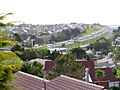
SH 1 as the Auckland Northern Motorway, looking north from Forrest Hill, North Shore.
-
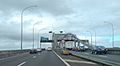
SH 1 crossing the Auckland Harbour Bridge.
-
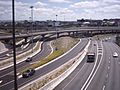
SH 1 through the Central Motorway Junction, also known as "Spaghetti Junction."
-
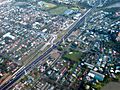
SH 1, as the Southern Motorway, in Ōtāhuhu, Auckland.
-
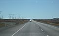
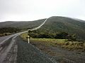
Traveling north on SH 1 through the Rangipo Desert. This section is known as the Desert Road and can close due to snow in winter.
-
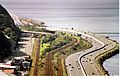
SH 1 as the Wellington Urban Motorway, running beside Wellington Harbour.
-
SH 1 passing through the North Canterbury town of Cheviot.
-
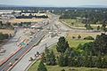
Upgrading of SH1 to four lanes in Harewood, Christchurch, with a new overpass at Memorial Avenue.
-
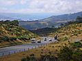
Dunedin-Waitati Hwy looking north from near the Pigeon Flat Overbridge. Blueskin Bay is visible in the background.
-
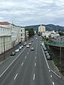
In Dunedin, the highway uses a pair of multi-lane one-way streets. This is Cumberland Street, about 1 km (0.6 miles) south of the city center.
-
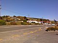
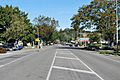
SH 1 in the Otago town of Waihola.
-

The signpost at Stirling Point, Bluff, marking the end of SH 1.


