
Mount Tongariro facts for kids
Quick facts for kids Mount Tongariro |
|
|---|---|
 |
|
| Highest point | |
| Elevation | 1,978 m (6,490 ft) |
| Geography | |
| Location | New Zealand |
| Geology | |
| Age of rock | 275,000 Years |
| Mountain type | Complex volcano |
| Volcanic arc/belt | Taupo Volcanic Zone |
| Last eruption | 21 November 2012 13:50 |
| Climbing | |
| Easiest route | Tongariro Alpine Crossing |
Mount Tongariro is a large volcano found in the Taupo Volcanic Zone on the North Island of New Zealand. It is about 20 kilometers (12 miles) southwest of Lake Taupo. Tongariro is the most northern of three active volcanoes that stand out in the central North Island.
Contents
Understanding Tongariro's Geology
Mount Tongariro is part of a group of volcanoes called the Tongariro volcanic center. This center includes four main mountains made of a rock called andesite: Tongariro, Kakaramea, Pihanga, and Ruapehu. Tongariro is a steep, cone-shaped volcano, known as a stratovolcano. It is made up of many layers of hardened lava and volcanic ash. The volcano first erupted about 275,000 years ago and reaches a height of 1,978 meters (6,490 feet).
Tongariro has at least 12 separate cones. Ngauruhoe is often seen as its own mountain. However, it is actually one of Tongariro's cones. Ngauruhoe is also the most active part of the volcano. It has erupted more than 70 times since 1839. Its last eruptions were between 1973 and 1975.
Other parts of Tongariro have also been active recently. The Te Māri Craters erupted in 2012. This was their first eruption since 1897. Red Crater last erupted ash in 1926. It still has active steam vents called fumaroles. Many explosion craters exist on the mountain. Some of these have filled with water, forming beautiful lakes like the Blue Lake and the Emerald Lakes.
The high altitude and cold weather from March to October bring a lot of snow in winter. Rain can also freeze, creating a dangerous ice glaze. In late summer, the mountains can be mostly bare. Unlike nearby Mt. Ruapehu, Tongariro does not have any glaciers today. However, scientists have found signs that glaciers were once present here.
History of Tongariro
Mount Tongariro is located within the Tongariro National Park. This was New Zealand's first national park and one of the earliest in the world. It was set aside in 1887 by Te Heuheu Tukino IV (Horonuku). He was the main chief of the Māori Ngati Tuwharetoa tribe. He wanted to protect the area's natural beauty. The park also includes the peaks of Ngauruhoe and Ruapehu. These mountains are southwest of Tongariro. The national park is a special World Heritage Site. It is recognized for its amazing natural beauty and important cultural meaning.
A popular hiking trail called the Tongariro Alpine Crossing goes between Tongariro and Ngauruhoe. This trail offers stunning views of the volcanic landscape.
Mount Tongariro and its surroundings were also chosen by director Peter Jackson. He used the area to film parts of The Lord of the Rings movies.
The 2012 Te Māri Eruptions

On August 6, 2012, at 11:50 PM, Mount Tongariro erupted. This happened after a month of increased activity. The eruption took place at the Te Māri Craters. These craters had been quiet since 1897.
The eruption started from a new opening below the Upper Te Māri crater. It threw rocks as large as 1 meter (3 feet) up to 2 kilometers (1.2 miles) away.
An ash cloud rose 6.1 kilometers (3.8 miles) high. It dropped ash over the surrounding area, especially to the east of the volcano. The ash cloud traveled 250 kilometers (155 miles) in just four hours. Scientists reported the ash cloud contained about 10,000 cubic meters (353,147 cubic feet) of ash. The cloud was 25 kilometers (15.5 miles) long and 15 kilometers (9.3 miles) wide soon after the eruption. People in Napier and Hastings reported ash and the smell of sulphur. The smell of sulphur was also noticed in Wellington, Nelson, and Blenheim.
State Highway 1 to the east and State Highway 46 to the north of the mountain were covered with up to 5 centimeters (2 inches) of ash. These roads were closed until the next morning because of the ash and poor visibility. Farmland about 5 to 10 kilometers (3 to 6 miles) east of Mount Tongariro had a layer of ash 10 to 15 millimeters (0.4 to 0.6 inches) thick.
The air space within 12 kilometers (7.5 miles) of the mountain was closed after the eruption. It later reopened for certain types of flights. Air New Zealand canceled some flights to and from cities like Rotorua, Taupo, Gisborne, Napier, Wanganui, and Palmerston North. This was due to the risk of volcanic ash damaging aircraft engines.
No one was reported injured during the eruption. The only major damage was to the Department of Conservation's Ketetahi Hut. This hut is about 1.5 kilometers (0.9 miles) west of the Te Māri Craters. There was no official order to leave, but 24 people living near State Highway 46 left their homes. They were worried about being cut off.
Mount Tongariro erupted again at 1:20 PM on November 21. It sent an ash cloud 4,000 meters (13,123 feet) into the air. Flights in the area were canceled, and some were canceled the next morning too. Geologists had no warning before this eruption. They said it was not connected to warnings about activity at nearby Mount Ruapehu the week before.
Images for kids
-
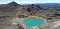
Emerald Lakes from the summit of Red Crater

See also
 In Spanish: Tongariro para niños
