
Blenheim, New Zealand facts for kids
Quick facts for kids
Blenheim
Waiharakeke (Māori)
|
|
|---|---|
|
Urban area
|
|

Blenheim pictured from the International Space Station (ISS)
|
|

Blenheim
Location in New Zealand
|
|
| Country | New Zealand |
| Region | Marlborough |
| Territorial authority | Marlborough District |
| Named for | Battle of Blenheim |
| Member of Parliament | Stuart Smith, Kaikoura Electorate |
| Suburbs |
List
Blenheim
Burleigh Farnham Fairhall Grovetown Islington Mayfield Omaka Redwoodtown Renwick Riverlands Riversdale Roselands Solar Heights Spring Creek Springlands St Andrews Witherlea Wither Hills Wither Rise Woodbourne Yelverton |
| Area | |
| • Total | 27.46 km2 (10.60 sq mi) |
| Population
(June 2023)
|
|
| • Total | 30,500 |
| • Density | 1,110.7/km2 (2,877/sq mi) |
| Postcode |
7201
|
| Area code(s) | 03 |
Blenheim is a lively town in the Marlborough Region of New Zealand. It's the biggest town in this area, located in the northeast of the South Island. Blenheim is home to about 30,500 (June 2023). people.
The area around Blenheim is famous for its New Zealand wine industry. It's one of the sunniest places in New Zealand. Summers are warm and dry, while winters are cool and clear.
The town got its name from the Battle of Blenheim in 1704. In this battle, troops led by the Duke of Marlborough won a big victory. Blenheim's Māori name is Waiharakeke, which means "flax stream."
Contents
History of Blenheim

Long ago, around the 12th century, Māori people lived in the sheltered bays of Marlborough. They found plenty of food from the sea and birds. As more Māori lived here, they changed the land to grow food.
In the early 1700s, they dug canals and waterways. This helped them farm fish and native water birds. About 18 kilometers of these channels were made before Europeans arrived. Māori also grew crops like kūmara (sweet potato).
The area was also where the first big clash happened between Māori and British settlers. This was after the Treaty of Waitangi was signed. It was called the Wairau Affray and took place near the village of Tuamarina.
Early European settlers first called the town The Beaver or Beaverton. This was because it often flooded.
Marlborough was once part of the Nelson settlement. But people in Marlborough wanted to be independent. In 1859, their wish was granted, and Marlborough became its own province.
Gold was found in the early 1860s, but the gold rush didn't last long. What really helped the region grow was sheep farming. Large sheep farms, called runs, became very important. They were as big and wealthy as those in Canterbury.
Geography and Climate


Blenheim is located on the Wairau Plain. The town is mostly flat, except for its southern edge. This part rises towards the Wither Hills. Mountains surround the plain on three sides. The eastern side is open to Cook Strait. This protects Blenheim from cold winter weather.
However, strong winds can blow through the area. Winds from the west are funneled down the Wairau Valley towards the town. Winds from Cook Strait also hit open areas hard.
Blenheim sits where the Taylor and Ōpaoa rivers meet. The area is active with earthquakes. Usually, these are small. Blenheim is near the boundary of two large tectonic plates.
Blenheim's Weather
Blenheim has very stable weather. This is because mountains to the west block most heavy rains. This is called a rain shadow effect.
Summers are usually warm, dry, and sunny. Winter mornings are cool and often frosty. Snow rarely falls because mountains protect the town from cold southern weather. Rain and humidity are highest in winter and early spring.
The town gets about 700mm of rain each year. It rains on about 81 days. Thunderstorms are not common. They are more likely in summer when heat builds clouds over the mountains.
The hottest temperature ever recorded was 37.8 °C on February 7, 1973. The coldest was −8.8 °C.
| Climate data for Blenheim (1991–2020 normals, extremes 1932–present) | |||||||||||||
|---|---|---|---|---|---|---|---|---|---|---|---|---|---|
| Month | Jan | Feb | Mar | Apr | May | Jun | Jul | Aug | Sep | Oct | Nov | Dec | Year |
| Record high °C (°F) | 36.5 (97.7) |
37.8 (100.0) |
32.7 (90.9) |
28.8 (83.8) |
24.4 (75.9) |
22.0 (71.6) |
19.8 (67.6) |
23.8 (74.8) |
27.6 (81.7) |
30.2 (86.4) |
32.8 (91.0) |
34.2 (93.6) |
37.8 (100.0) |
| Mean daily maximum °C (°F) | 23.4 (74.1) |
23.3 (73.9) |
21.5 (70.7) |
18.8 (65.8) |
16.6 (61.9) |
13.9 (57.0) |
13.3 (55.9) |
14.4 (57.9) |
16.3 (61.3) |
18.4 (65.1) |
19.9 (67.8) |
21.8 (71.2) |
18.5 (65.3) |
| Daily mean °C (°F) | 18.1 (64.6) |
17.9 (64.2) |
16.1 (61.0) |
13.5 (56.3) |
11.2 (52.2) |
8.8 (47.8) |
8.1 (46.6) |
9.2 (48.6) |
11.2 (52.2) |
13.1 (55.6) |
14.7 (58.5) |
16.8 (62.2) |
13.2 (55.8) |
| Mean daily minimum °C (°F) | 12.9 (55.2) |
12.5 (54.5) |
10.7 (51.3) |
8.2 (46.8) |
5.9 (42.6) |
3.6 (38.5) |
2.9 (37.2) |
4.0 (39.2) |
6.2 (43.2) |
7.9 (46.2) |
9.6 (49.3) |
11.8 (53.2) |
8.0 (46.4) |
| Record low °C (°F) | 1.3 (34.3) |
−0.1 (31.8) |
−1.1 (30.0) |
−4.1 (24.6) |
−5.3 (22.5) |
−8.8 (16.2) |
−6.1 (21.0) |
−6.2 (20.8) |
−4.0 (24.8) |
−3.6 (25.5) |
−2.9 (26.8) |
−0.3 (31.5) |
−8.8 (16.2) |
| Average rainfall mm (inches) | 43.0 (1.69) |
44.6 (1.76) |
39.4 (1.55) |
53.8 (2.12) |
56.9 (2.24) |
68.6 (2.70) |
64.2 (2.53) |
57.9 (2.28) |
54.4 (2.14) |
57.2 (2.25) |
49.1 (1.93) |
49.7 (1.96) |
638.8 (25.15) |
| Average rainy days (≥ 1.0 mm) | 4.8 | 4.2 | 4.7 | 5.8 | 7.0 | 7.6 | 7.2 | 7.6 | 7.4 | 7.2 | 6.3 | 6.1 | 75.9 |
| Average relative humidity (%) | 68.7 | 74.2 | 74.9 | 77.5 | 81.5 | 82.3 | 83.7 | 80.8 | 73.3 | 72.1 | 67.7 | 67.5 | 75.4 |
| Mean monthly sunshine hours | 261.8 | 233.4 | 233.3 | 190.4 | 178.9 | 151.8 | 160.0 | 189.2 | 198.8 | 232.6 | 242.7 | 248.5 | 2,521.4 |
| Percent possible sunshine | 57 | 60 | 61 | 58 | 59 | 56 | 54 | 54 | 56 | 57 | 56 | 53 | 57 |
| Source 1: NIWA Climate Data (humidity 1981–2010 | |||||||||||||
| Source 2: Weather Spark | |||||||||||||
People of Blenheim
Blenheim is home to many different people. In 2018, the town had about 26,835 residents. The population has been growing steadily over the years.
Most people in Blenheim are of European descent. There are also many Māori residents. Smaller groups include people from the Pacific Islands and Asia.
About half of the people in Blenheim say they have no religion. Many others identify as Christian. There are also smaller groups with Māori religious beliefs, Hinduism, Islam, and Buddhism.
Many people in Blenheim work full-time or part-time. Some are still looking for jobs. About 14% of adults have a university degree.
Blenheim's Suburbs


Blenheim has several neighborhoods, called suburbs. Some are closer to the town center, while others are a bit further out.
- Inner suburbs:
- Blenheim CBD (Central Business District)
- Burleigh
- Farnham
- Islington
- Mayfield
- Redwoodtown
- Riversdale
- Roselands
- Solar Heights
- Springlands
- St Andrews
- Witherlea
- Wither Hills
- Wither Rise
- Yelverton
- Outer suburbs:
- Fairhall
- Grovetown
- Omaka
- Renwick
- Riverlands
- Spring Creek
- Woodbourne
Economy and Wine Production
Blenheim's economy relies on farming services. Pastoral farming (raising sheep and cattle) and horticulture (growing fruits and vegetables) are very important. In the past, sheep, dairy, wheat, and barley were the main products.
Since 1973, growing grapes for wine has become the biggest industry. Many people work in wine production. Wine tourism also brings many visitors. Olive growing has also become important recently.
Even though Blenheim is inland, sea-related industries are also key. Lake Grassmere has New Zealand's only salt works. It produces half of the country's salt. Fishing and mussel farming are also big in the region.
Marlborough Wine Region
The Marlborough wine region is New Zealand's largest. It is famous worldwide for its Sauvignon Blanc wines. Wine production greatly helps the local economy. It creates jobs and attracts tourists.
Hundreds of thousands of people visit the local wineries each year. The area also hosts the yearly Marlborough Wine & Food Festival. There are over 50 vineyards near Blenheim.
Lifestyle and Activities
Blenheim's sunny weather attracts many people. Some come for holidays, and others move here permanently. It's a popular place for retired people and those seeking a relaxed lifestyle.
The Marlborough Region offers many outdoor activities. People enjoy the relaxed pace of life. The growing wine and food industry is popular with both locals and visitors.
Fun Places and Events


The Omaka Aerodrome, south of town, hosts the Classic Fighters Marlborough airshow every two years. This show features many old aircraft, especially from World War One.
Seymour Square and Pollard Park are great places for walks. Seymour Square is a public area in the town center. It has a War Memorial and Clock Tower built in 1928. Pollard Park is a large public park with play areas, rose gardens, and a waterway. It also has a golf course, tennis courts, and a croquet club.
The GCSB Waihopai facility, which monitors communications, is located near Blenheim.
Getting Around Blenheim
By Air
Woodbourne Airport is a local airport and a base for the RNZAF. You can fly directly from Auckland and Wellington with Air New Zealand. Sounds Air also flies from Wellington, Christchurch, and Paraparaumu.
Omaka Aerodrome is used by private and old airplanes. The Classic Fighters airshow is held here every two years.
By Road
State Highway 1 goes through Blenheim. State Highway 6 also ends here. Blenheim is special because it uses roundabouts instead of traffic lights at intersections. This helps traffic flow faster.
By Train
Blenheim is on the Main North Line railway. The Coastal Pacific, a long-distance passenger train, stops at Blenheim railway station. The train station was built in 1906. It is a historic building.
A large rail freight center is located north of Blenheim at Spring Creek. The Blenheim Riverside Railway is a narrow-gauge train that runs through the town.
Schools in Blenheim
The first school in Blenheim opened in 1859. Today, there are many schools for children of all ages.
- Blenheim School is a primary school for Year 1–6 students.
- Bohally Intermediate is for Year 7–8 students. It opened in 1957.
- Marlborough Boys' College is a secondary school for boys (Year 9–13).
- Marlborough Girls' College is a secondary school for girls (Year 9–13).
- Mayfield School is a primary school in Mayfield.
- Redwoodtown School is a primary school in Redwoodtown.
- Richmond View School is a Christian school for Year 1–13 students.
- Springlands School is a primary school in Springlands.
- St Mary's School is a Catholic primary school.
- Whitney Street School is a primary school.
- Witherlea School is a primary school in Witherlea.
The Nelson Marlborough Institute of Technology also has a campus in Blenheim. This is for older students who want to learn trades or other skills.
Media in Blenheim
Blenheim has several newspapers. The Marlborough Express is the main daily newspaper. The Saturday Express and Midweek are community newspapers.
The Blenheim Sun is a free newspaper published twice a week. The Marlborough Weekly is another local newspaper.
Blenheim also has many radio stations. You can even pick up radio stations from Wellington because of the clear line of sight across Cook Strait.
Notable People from Blenheim
Many interesting people have come from Blenheim, including:
- Rosina Buckman, an opera singer
- Frank Devine, an editor and journalist
- Jamie Joseph, a rugby player
- Leon MacDonald, a rugby player
- Liam Messam, a rugby player
- Ben O'Keeffe, a rugby referee
- Ben Sigmund, a footballer
- Alan Sutherland, a rugby player
- David Teece, a well-known economist
- Ian Wedde, an author
Images for kids
-
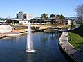
The Taylor River Geyser
See also
 In Spanish: Blenheim (Nueva Zelanda) para niños
