Springlands facts for kids
|
|
||
Springlands is a friendly suburb located just west of Blenheim, a town in New Zealand. It sits along State Highway 6, which is the main road leading to Renwick. In Springlands, you can find a local tavern, places to grab a quick meal, and a large superstore for shopping.
Contents
Who Lives in Springlands?
This section tells us about the people who live in Springlands. It also describes how the population has changed over time.
Population and Area
Springlands covers about 5.30 square kilometers (which is about 2 square miles). As of 2023, it has an estimated population of over 7,900 people. This means there are about 1,500 people living in each square kilometer.
How Springlands Has Grown
Springlands has been growing steadily.
- In 2006, about 5,016 people lived here.
- By 2013, the population grew to 5,376.
- In 2018, it reached 5,880 people.
This shows that more and more people are choosing to call Springlands home!
Diversity in Springlands
Springlands is a diverse place with people from many backgrounds.
- Most residents (86.6%) are of European or Pākehā heritage.
- About 10.8% identify as Māori.
- There are also people from Pacific Island (4.1%) and Asian (5.8%) backgrounds.
- About 19.7% of the people living in Springlands were born outside New Zealand. This is a bit lower than the national average for New Zealand.
Beliefs and Education
When asked about their religious beliefs, nearly half (46.6%) of the people in Springlands said they had no religion. Many others (42.6%) identified as Christian. A small number followed Māori religious beliefs, Hindu, Muslim, or Buddhist faiths.
Many adults in Springlands have good education. About 16.7% have a university degree or higher.
Schools in Springlands
Springlands is home to three schools, offering education from primary years right through to high school.
Springlands School
Springlands School is a primary school for students in Years 1 to 6 (ages 5-10). It has about 470 students and first opened its doors in 1886.
Bohally Intermediate
Bohally Intermediate is a school for Years 7 and 8 (ages 11-12). It opened in 1957 and has about 570 students. This school helps students transition between primary and secondary education.
Marlborough Girls' College
Marlborough Girls' College is a secondary school for girls in Years 9 to 13 (ages 13-17). It opened in 1963 and has about 900 students. Both Springlands School and Bohally Intermediate are coeducational, meaning they teach both boys and girls.
Historic Power Station
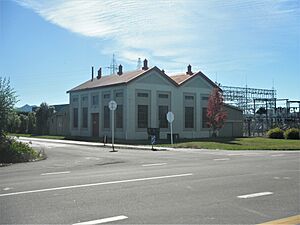
On Old Renwick Road, there's an old industrial building with diesel generators that are nearly 100 years old! These generators were built in 1930.
Before the mid-1950s, the Marlborough region was not connected to New Zealand's main electricity network. Electricity first came from a small hydro station (which uses water to make power). In 1930, the diesel generator in Springlands was set up. It provided backup power when the hydro station couldn't produce enough electricity. Another generator was added in 1937.
These old generators have been kept by Marlborough Lines, the local power company. They are an important part of the history of electricity in the region.
 | James Van Der Zee |
 | Alma Thomas |
 | Ellis Wilson |
 | Margaret Taylor-Burroughs |


