Gisborne, New Zealand facts for kids
Quick facts for kids
Gisborne
Tūranga-nui-a-Kiwa (Māori)
|
||
|---|---|---|
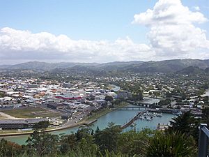
Central and northeastern Gisborne viewed from Kaiti Hill
|
||
|
||
| Country | New Zealand | |
| Region | Gisborne District | |
| Area | ||
| • Total | 37.43 km2 (14.45 sq mi) | |
| Population
(June 2023)
|
||
| • Total | 38,200 | |
| • Density | 1,020.6/km2 (2,643/sq mi) | |
| Time zone | UTC+12 (NZST) | |
| • Summer (DST) | UTC+13 (NZDT) | |
| Area code(s) | 06 | |
| Website | GDC.govt.nz | |
Gisborne is a city located in the northeastern part of New Zealand. It is the largest town in the Gisborne District, also known as the Gisborne Region. About 38,200 (June 2023). people live there. The main offices for the Gisborne District Council are in the city center.
Contents
About the Name of Gisborne
The area where Gisborne is now was known in the Māori language as Tūranganui-a-Kiwa. This means 'the great standing place of Kiwa'. It was named after Kiwa, who arrived there on a traditional canoe called Tākitimu.
The first English name for the settlement was Tūranga. In 1870, it was renamed Gisborne. This was to honor William Gisborne, who was the Colonial Secretary of New Zealand at the time. The name change also helped avoid confusion with another town called Tauranga.
Early History of Gisborne
First People Arrive
People have lived in the Gisborne region for more than 700 years. For many centuries, different Māori tribes lived here. These tribes include Te Whānau-a-Kai, Ngaariki Kaiputahi, Te Aitanga-a-Māhaki, Rongowhakaata, Ngāi Tāmanuhiri, and Te Aitanga-a-Hauiti. They are descendants of voyagers who arrived on canoes like Te Ikaroa-a-Rauru, Horouta, and Tākitimu.
Māori stories tell different versions of how Gisborne was first settled. One story says that in the 14th century, a great navigator named Kiwa landed at the Tūranganui River. He arrived on the canoe Tākitimu. Another story says that Pāoa, captain of the canoe Horouta, arrived later.
A different story says that Kiwa waited so long for the Horouta canoe that he named the place Tūranganui-a-Kiwa, meaning 'the long waiting place of Kiwa'. Many people believe that the Horouta canoe arrived first. In the 14th century, Māori tribes built fishing villages near the sea. They also built fortified villages called pā on nearby hilltops.
Captain Cook's Landing
Gisborne's Kaiti Beach is famous as the place where British navigator Captain James Cook first landed in New Zealand. He arrived on his ship, the Endeavour. Cook had left Plymouth, England, in August 1768, on a trip to Tahiti. After his work in Tahiti, Cook sailed south to look for a large landmass.
Young Nick's Head was the first part of New Zealand that Cook's group saw. It was named after cabin boy Nicholas Young, who spotted it on October 6, 1769. On October 9, Cook and his men came ashore on the eastern side of the Tūranganui River. Their arrival led to misunderstandings and conflict with the local Māori.
The town of Turanga, and later Gisborne, grew on the banks of the Tūranganui River. This happened as European traders and whalers began to settle in the area. A monument was built in 1906 to remember Cook's landing. In 2019, a memorial was put up on Titirangi hill to honor Te Maro. He was one of the first Māori casualties when the Endeavour arrived.
European Settlement and Town Growth
In the early 1830s, traders like Captain John Harris and Captain George E. Read set up the first trading posts. They are known for helping to start the town. Over the next 30 years, more European traders and missionaries moved to the region.
In 1868, the government bought land for a town site. The town was planned in 1870, and its name changed from Turanga to Gisborne. This was to honor the colonial secretary and avoid confusion with Tauranga. Gisborne's first public school opened in 1872. The town's first newspaper, the Poverty Bay Standard, also started then. A town council was formed in 1877 to manage the growing town.
Geography of Gisborne
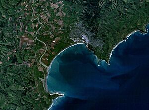
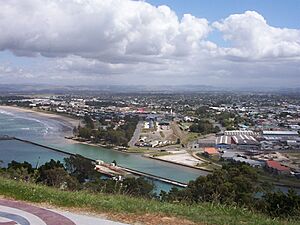
Gisborne is on the east coast of New Zealand's North Island. It is in the southern part of the Gisborne District and on the north side of Poverty Bay. The flat areas around Poverty Bay include Gisborne city and nearby places like Mākaraka and Ormond. These areas are known for vineyards and farms. Gisborne is flat near the coast but becomes hilly and forested further inland.
Gisborne has many beautiful white sand beaches. These include Waikanae, Midway, Kaiti, Sponge Bay, Wainui, and Makorori beaches. They are popular for swimming and surfing. Gisborne is sometimes called the 'City of Rivers' because the Waimata, Taruheru, and Tūranganui rivers meet there. The Tūranganui River is only 1.2 kilometers long, making it the shortest river in New Zealand.
Kaiti Hill (also called Titirangi) is right above Cook's landing site. It offers amazing views of the city and Poverty Bay. Many old sites have been found on Titirangi, including burial grounds and old terraces. Titirangi Pā is near the top of the hill.
In the wider area around Gisborne, there are two large tree collections called arboreta. Eastwoodhill Arboretum is the National Arboretum of New Zealand. It covers over 130 hectares. The smaller 50-hectare Hackfalls Arboretum is in Tiniroto.
Gisborne used to claim to be the first city in the world to see the sun rise each day. This was true until Samoa and Tokelau changed their time zone in December 2011. Now, Gisborne is only the first to see the sunrise during New Zealand's summer months.
Gisborne's Climate
The high land to the west protects Gisborne. The city has a temperate oceanic climate. This means it has warm summers and cool winters. Temperatures rarely drop below 0 °C (32 °F) and sometimes go above 30 °C (86 °F). Gisborne gets about 2,200 hours of sunshine each year.
The amount of rain changes from about 1000 mm (39 in) near the coast to over 2500 mm (98 in) in the higher inland areas. Gisborne has some of the warmest summer daytime temperatures among official stations in New Zealand.
| Climate data for Gisborne (1991–2020 normals, extremes 1905–present) | |||||||||||||
|---|---|---|---|---|---|---|---|---|---|---|---|---|---|
| Month | Jan | Feb | Mar | Apr | May | Jun | Jul | Aug | Sep | Oct | Nov | Dec | Year |
| Record high °C (°F) | 38.2 (100.8) |
36.6 (97.9) |
35.1 (95.2) |
31.0 (87.8) |
27.8 (82.0) |
23.2 (73.8) |
21.2 (70.2) |
23.0 (73.4) |
27.1 (80.8) |
30.8 (87.4) |
34.8 (94.6) |
37.2 (99.0) |
38.2 (100.8) |
| Mean daily maximum °C (°F) | 25.8 (78.4) |
25.7 (78.3) |
23.8 (74.8) |
20.9 (69.6) |
18.4 (65.1) |
15.7 (60.3) |
14.7 (58.5) |
15.7 (60.3) |
17.6 (63.7) |
20.1 (68.2) |
21.7 (71.1) |
23.8 (74.8) |
20.3 (68.5) |
| Daily mean °C (°F) | 20.1 (68.2) |
20.2 (68.4) |
18.3 (64.9) |
15.6 (60.1) |
13.2 (55.8) |
10.8 (51.4) |
10.1 (50.2) |
10.7 (51.3) |
12.6 (54.7) |
14.7 (58.5) |
16.3 (61.3) |
18.5 (65.3) |
15.1 (59.2) |
| Mean daily minimum °C (°F) | 14.3 (57.7) |
14.7 (58.5) |
12.8 (55.0) |
10.3 (50.5) |
8.0 (46.4) |
5.9 (42.6) |
5.5 (41.9) |
5.7 (42.3) |
7.6 (45.7) |
9.3 (48.7) |
10.9 (51.6) |
13.1 (55.6) |
9.8 (49.6) |
| Record low °C (°F) | 2.2 (36.0) |
3.3 (37.9) |
0.8 (33.4) |
−1.7 (28.9) |
−3.4 (25.9) |
−3.9 (25.0) |
−4.4 (24.1) |
−5.3 (22.5) |
−2.3 (27.9) |
−0.6 (30.9) |
−0.6 (30.9) |
0.0 (32.0) |
−5.3 (22.5) |
| Average rainfall mm (inches) | 71.4 (2.81) |
65.9 (2.59) |
94.0 (3.70) |
107.1 (4.22) |
84.0 (3.31) |
107.4 (4.23) |
118.7 (4.67) |
78.1 (3.07) |
73.1 (2.88) |
76.1 (3.00) |
65.2 (2.57) |
59.9 (2.36) |
1,000.9 (39.41) |
| Average rainy days (≥ 1.0 mm) | 6.2 | 7.6 | 9.0 | 9.4 | 9.9 | 10.2 | 12.4 | 11.1 | 8.7 | 7.3 | 7.8 | 7.2 | 106.8 |
| Average relative humidity (%) | 70.0 | 77.4 | 79.8 | 80.5 | 81.1 | 82.4 | 82.3 | 78.6 | 72.4 | 71.5 | 68.3 | 68.7 | 76.1 |
| Mean monthly sunshine hours | 259.9 | 204.9 | 193.0 | 165.3 | 151.3 | 133.2 | 130.3 | 172.6 | 189.4 | 230.9 | 228.6 | 236.9 | 2,296.3 |
| Source: NIWA Climate Data | |||||||||||||
People of Gisborne
| Historical population of Gisborne District | ||
|---|---|---|
| Year | Pop. | ±% |
| 1986 | 45,758 | — |
| 1991 | 44,361 | −3.1% |
| 1996 | 45,962 | +3.6% |
| 2001 | 43,971 | −4.3% |
| 2006 | 44,463 | +1.1% |
| 2013 | 43,656 | −1.8% |
In 2018, the Gisborne urban area had 34,527 people living there. This was an increase of 3,294 people since the 2013 census. There were more females (17,907) than males (16,623). About 23.8% of the population was aged 15 years or younger.
Most people in Gisborne identified as European (Pākehā), making up 58.8% of the population. A large part of the population, 51.6%, identified as Māori. Other groups included Pacific peoples (5.3%) and Asian people (3.5%). People could choose more than one ethnic group.
The unemployment rate for people aged 15 and over was 9.4% in Gisborne. This was higher than the national average of 7.4%. The average yearly income for people 15 and over was $24,400. This was less than the national average of $28,500.
Only 9.7% of Gisborne's population was born overseas. This is much lower than the New Zealand average of 25.2%. The largest group of people born overseas were from Britain. Most people in Gisborne (73.0%) speak only one language. About 16.2% can speak two languages.
Gisborne's Economy
The harbor in Gisborne was once a busy place for many ships. It was developed as a river port because it was safer than the open waters of Poverty Bay. In the past, meat and wool were shipped from here. Today, the harbor is home to many smaller fishing boats. Large ships also load logs for export. In 2018, the Gisborne port received money to help it grow.
Gisborne still has a rural feel and is a popular place for holidays. The main industries in the area include farming, growing plants and trees (horticulture), and forestry. Making wine is also an important part of the local economy.
Getting Around Gisborne
Air Travel
Gisborne Airport is the local airport for the Gisborne District. Air New Zealand offers regular flights to Auckland and Wellington. A smaller airline, Air Napier, flies to Napier and Wairoa. Sunair also offers flights from Gisborne to Hamilton and Tauranga.
Main Roads
![]() State Highway 2 connects Gisborne to other cities. It goes northwest to Tauranga, passing through Ōpōtiki and Whakatāne. To the south, it connects to Napier and the rest of Hawke's Bay through Wairoa. This highway goes through Makaraka, a suburb of Gisborne, and crosses the Waipaoa River.
State Highway 2 connects Gisborne to other cities. It goes northwest to Tauranga, passing through Ōpōtiki and Whakatāne. To the south, it connects to Napier and the rest of Hawke's Bay through Wairoa. This highway goes through Makaraka, a suburb of Gisborne, and crosses the Waipaoa River.
![]() State Highway 35 is part of the Pacific Coast Highway. It starts near Gisborne, bordering Gisborne Airport. It then goes through the city and continues up the coast towards the East Cape.
State Highway 35 is part of the Pacific Coast Highway. It starts near Gisborne, bordering Gisborne Airport. It then goes through the city and continues up the coast towards the East Cape.
Public Transport
Public transport in Gisborne is not very common. Only a small number of trips are made by bus. Go Bus runs 30 services a day on 4 routes, Monday to Friday. These buses are called Gizzy Bus. You can pay for fares with a Bee Card or cash.
From 1913 to 1929, Gisborne had battery-powered trams. Since then, public transport use has decreased a lot.
Rail Transport
Gisborne is the northern end of the Palmerston North - Gisborne Line railway. This railway opened in 1942 but stopped operating in 2012. The tracks have been damaged by storms, and it is unlikely the line will open again for regular trains.
In the past, there were passenger train services between Gisborne and Wellington until 1988. Today, only the Gisborne City Vintage Railway offers short, historical train rides from Gisborne.
Culture in Gisborne
Te Poho-o-Rawiri and Te Kuri a Tuatai marae are important Māori meeting places located in the city.
The Tairāwhiti Museum is a museum in Gisborne. It holds a collection of Māori artifacts. It was once the home of William Lysner, who collected these items.
The Tairāwhiti Tamararo Regionals is an annual haka competition held in Gisborne. It honors Karaitiana Tamararo.
Gisborne also hosts Rhythm & Vines, a yearly music festival. It takes place over New Year's at Waiohika Estate. Since 2019, the Te Tairāwhiti Arts Festival is another annual event in the region, with many activities happening in Gisborne.
Sports in Gisborne
Gisborne is home to the Poverty Bay Rugby Football Union in rugby union. They play in the Heartland Championship. The city also has several local rugby clubs.
In rugby league, the Gisborne Taraiwhiti has represented the city. Currently, Gisborne is represented in the National Competition by the Waicoa Bay Stallions.
The Poverty Bay cricket team plays in the Hawke Cup. First-class cricket matches are sometimes held at Harry Barker Reserve. Local cricket clubs include High School Old Boys (HSOB) and OBR.
In football, several clubs from Gisborne compete in local competitions. These include Gisborne Thistle AFC and Gisborne United AFC. The former Gisborne City AFC won the Chatham Cup in 1987.
Netball in Gisborne is organized by the Gisborne Netball Centre. Many netball teams are linked to rugby or football clubs.
Other popular sports in Gisborne include golf, basketball, rowing, hockey, tennis, and squash.
Awapundi Speedway is a track for motorcycle speedway and car racing. It hosts different types of races, including sidecars and stockcars. The track has also held important events like qualifying rounds for the Speedway World Championship.
Education in Gisborne
Gisborne City has four main high schools:
- Gisborne Boys' High
- Gisborne Girls' High
- Lytton High
- Campion College (a Catholic school for both boys and girls)
Suburbs of Gisborne
- Awapuni
- Elgin
- Gaddums Hill
- Ilminster
- Inner Kaiti
- Kaiti
- Makaraka
- Manutuke
- Mangapapa
- Makorori
- Riverdale
- Riverside
- Riverview
- Sponge Bay
- Tamarau
- Te Hapara
- Te Wharau
- Victoria
- Waikanae
- Waikirikiri
- Wainui Beach
- Whataupoko
Sister Cities of Gisborne
Gisborne has special connections with other cities around the world. These are called sister cities.
 Mahina, French Polynesia
 Nonoichi, Ishikawa, Japan
 Palm Desert, California, United States
 Rizhao, Shandong, China
Sister Port
 Gamagōri, Aichi, Japan
Friendly Cities
 Cassino, Italy
 Shire of Macedon Ranges, Victoria, Australia
 Valverde del Majano, Spain
 Wenchang, Hainan, China
 Whitby, England, United Kingdom
See also
 In Spanish: Gisborne (ciudad) para niños
 | Frances Mary Albrier |
 | Whitney Young |
 | Muhammad Ali |


