
Hawke's Bay facts for kids
Quick facts for kids
Hawke's Bay
Te Matau-a-Māui (Māori)
|
|
|---|---|
|
Region
|
|
|
|
|

Hawke's Bay within the North Island, New Zealand
|
|
| Country | New Zealand |
| Seat | Napier |
| Government | |
| • Type | Regional council |
| • Body | Hawke's Bay Regional Council |
| Area | |
| • Land | 14,139.15 km2 (5,459.16 sq mi) |
| Highest elevation
(Kaweka J)
|
1,724 m (5,656 ft) |
| Population
(June 2023)
|
|
| • Total | 184,800 |
| ISO 3166 code | NZ–HKB |
| HDI (2021) | 0.913 very high · 12th |
| Regional GDP | (2022 estimate) |
| · Total | NZ$10.708 billion · (8th) |
| · per capita | NZ$58,769 · (11th) |


Hawke's Bay (Māori: Te Matau-a-Māui) is a beautiful region on the east coast of New Zealand's North Island. It's named after Hawke Bay, which was named to honor Edward Hawke, 1st Baron Hawke. The biggest cities in the region are Napier and Hastings. Smaller towns like Waipukurau, Waipawa, and Wairoa serve the countryside areas.
Contents
What's in a Name?

Hawke's Bay gets its name from the large bay on its eastern side, called Hawke Bay. Captain James Cook named this bay to honor Edward Hawke, 1st Baron Hawke during his travels around New Zealand.
The Māori name for Hawke's Bay is Te Matau-a-Māui. This means "the fishhook belonging to Māui". It comes from an old story where Māui pulled the islands of New Zealand out of the water. The story says that Hawke's Bay is the fishhook Māui used. Portland Island and Cape Kidnappers are like the two ends of the hook.
Hawke's Bay is one of only two places in New Zealand with an apostrophe in its name. The other is Arthur's Pass. Captain Cook first used an apostrophe, but sometimes he wrote it without one. Many New Zealanders now spell it without the apostrophe.
Hawke's Bay History

Hawke's Bay has a rich history, from early settlements to major natural events.
Early Days of Hawke's Bay
In the 1800s, people set up whaling stations along the bay's shores. These were places where whales were processed.
The area became a separate province of New Zealand in 1858. It was called Hawke's Bay Province. Before that, it was part of the Wellington Province. In 1876, all provinces in New Zealand were replaced with districts.
The 1931 Earthquake
On February 3, 1931, a huge earthquake hit Napier and Hastings. It was New Zealand's worst natural disaster. The earthquake measured 7.9 on the Richter scale and sadly killed 256 people.
After the earthquake, Napier was rebuilt. Today, it's famous for its unique Art Deco buildings. Every February, the city celebrates its history with the Art Deco Weekend. You can learn more about the earthquake at MTG Hawke's Bay museum.
Cyclone Gabrielle's Impact
In February 2023, Cyclone Gabrielle caused a lot of damage in Hawke's Bay. Heavy floods cut off power, phone, and internet to many homes. Rivers like the Tutaekuri River and Ngaruroro River burst their banks.
Many bridges were destroyed, and roads were closed. Some towns, like Omahu and parts of Wairoa, were flooded. People had to be evacuated, and some were rescued by helicopter. The cyclone caused a lot of damage across the region.
Geography and Nature
Hawke's Bay is located on the east coast of the North Island. It features a large, curved bay called Hawke Bay. This bay stretches for 100 kilometers from Māhia Peninsula to Cape Kidnappers.
The region has hilly coastal areas and flat floodplains. The Wairoa River is in the north. The wide, fertile Heretaunga Plains are around Hastings in the south. Inland, you'll find the Kaweka and Ruahine Ranges.
Rivers and Lakes
Five main rivers flow into Hawke's Bay: the Wairoa River, Mohaka River, Tutaekuri River, Ngaruroro River, and Tukituki River. Lake Waikaremoana is the largest lake in Hawke's Bay. It's also the fourth largest in the North Island.
The Longest Place Name
Hawke's Bay is home to a hill with the longest place name in New Zealand. It's also the longest in the world, according to the 2009 Guinness Book of Records! The name is Taumatawhakatangihangakoauauotamateaturipukakapikimaungahoronukupokaiwhenuakitanatahu. This hill is near Waipukurau in southern Hawke's Bay.
-
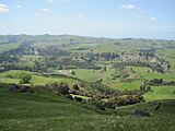
Countryside


_(cropped).jpg)

People and Population
Hawke's Bay Region covers about 14,139 square kilometers. In 2023, its population was 175,074 people. This means about 5.2% more people live there than in 2018.
Most people in Hawke's Bay live in the Napier-Hastings area. The median age in the region is 40.4 years. About 19.8% of the people are under 15 years old.
Who Lives in Hawke's Bay?
The 2023 census showed that the people of Hawke's Bay come from many backgrounds:
- 73.3% are European/Pākehā
- 28.6% are Māori
- 6.2% are Pasifika
- 6.5% are Asian
- 0.8% are Middle Eastern, Latin American, and African
- 1.2% are other ethnicities
Many people in Hawke's Bay were born overseas, about 15.9% of the population. The main local Māori tribe is Ngāti Kahungunu.
Main Towns and Cities
Here are the main urban areas in Hawke's Bay with more than 1,000 people:
| Urban area | Population (June 2023) |
% of region |
|---|---|---|
| Napier | 67,500 | 36.5% |
| Hastings | 51,500 | 27.9% |
| Havelock North | 15,200 | 8.2% |
| Wairoa | 5,020 | 2.7% |
| Waipukurau | 4,750 | 2.6% |
| Clive | 2,090 | 1.1% |
| Waipawa | 2,400 | 1.3% |
Other towns and settlements in Hawke's Bay include:
- Tuai
- Frasertown
- Nūhaka
- Mahia Beach
- Whirinaki
- Whakatu
- Haumoana
- Te Awanga
- Waimārama
- Tikokino
- Ongaonga
- Takapau
- Ōtāne
- Porangahau
Hawke's Bay Economy
Hawke's Bay has a strong economy, especially in farming and growing fruit.
Farming and Growing
The region is famous for its fruit orchards and vineyards. These are mostly found on the flat plains. In the hillier areas, sheep and cattle farming are common. There are also forests in the roughest parts of the region.
Hawke's Bay has a lot of land used for growing plants, about 17,886 hectares. The biggest crops grown here are apples, grapes for wine, squash, and peas and beans.
Wine Production

Hawke's Bay has a dry, mild climate with hot summers and cool winters. This weather is perfect for growing grapes. Missionaries planted the first grapevines here in the mid-1800s. Today, Hawke's Bay is known for its rich red wines. It's the second largest wine region in New Zealand.
Space and Aerospace
Hawke's Bay is home to Rocket Lab's Launch Complex 1. This is New Zealand's first place for launching rockets into space. It's located on Māhia Peninsula. The area around Wairoa is even called Space Coast New Zealand because you can watch rocket launches from there. Rocket Lab launches its Electron rockets several times a year.
Getting Around Hawke's Bay
Hawke's Bay has good ways to travel by air and road.
Air Travel
The main airport is Hawke's Bay Airport (also called Napier Airport). Many travelers use this airport each year. There's also a smaller airport near Hastings called Hastings Aerodrome.
Roads and Highways
You can travel into and out of Hawke's Bay using State Highway 2 and State Highway 5. The Taihape-Napier Road is another route.
- State Highway 2 connects Hawke's Bay to Gisborne in the north. It goes through towns like Wairoa and then into Napier and Hastings. It's the main road south from Napier-Hastings to cities like Palmerston North and Wellington.
- State Highway 5 is the Napier-Taupo Road. It connects Hawke's Bay to northern cities like Auckland, Hamilton, and Taupō.
- State Highway 50 connects inland parts of the region, including smaller settlements.
Culture and Fun
Hawke's Bay offers many cultural events and fun activities.
Hawke's Bay Anniversary Day
This is a special day of celebration held every year. It takes place on the Friday before Labour Day. People celebrate it throughout the old Hawke's Bay provincial area.
Media and Entertainment
The region has several radio stations, including Radio Kahungunu and The Hits 89.5. You can also listen to national radio stations.
Parks and Outdoor Activities


Hawke's Bay has many parks, forests, and beaches. Napier and Hastings have large parks like Cornwall, Frimley, and Windsor Parks.
At Windsor Park, you'll find Splash Planet. This is a fun amusement and water park that's open in the summer.
Cape Kidnappers is a popular spot for tourists. It's a headland where over 6,500 pairs of Australasian gannets come to breed. It's a great place to see these amazing birds!
Food and Wine

The Hawke's Bay wine region makes some of New Zealand's best wines. The region celebrates its food and wine twice a year with the Food And Wine Classic festivals. These events attract thousands of visitors from all over the world.
Music Events
Napier hosts the Mission Concert every year since 1993. This event takes place at the Mission Estate Winery in Taradale. Famous performers like Elton John, Rod Stewart, and Ray Charles have played there.
Sports in Hawke's Bay
The Hawke's Bay Rugby Union team, called the Magpies, plays in New Zealand's Mitre 10 Cup rugby competition. They play their home games at McLean Park in Napier. Some players from Hawke's Bay have even gone on to play for the All Blacks, New Zealand's national team!
The Hawke's Bay Hawks basketball team plays in the New Zealand National Basketball League.
Earthquakes in Hawke's Bay
Hawke's Bay is one of the most active earthquake regions in New Zealand. More than 50 strong earthquakes have happened here since the 1800s.
See also
 In Spanish: Región de Hawke's Bay para niños
