Tukituki River facts for kids
Quick facts for kids Tukituki River |
|
|---|---|

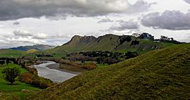
Tukituki River and Te Mata Peak, May 2006
|
|

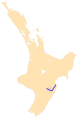
The Tukituki River system
|
|
| Native name | Tukituki |
| Country | New Zealand |
| Region | Hawkes Bay |
| Physical characteristics | |
| Main source | Ruahine Ranges |
| River mouth | Pacific Ocean Haumoana Sea Level 39°36′S 176°57′E / 39.600°S 176.950°E |
| Length | 117 kilometres (73 mi) |
The Tukituki River is an important river located in the eastern part of New Zealand's North Island. It begins in the Ruahine Ranges and flows all the way to the Pacific Ocean. The river reaches the ocean at the southern end of Hawke's Bay.
The Tukituki River travels for about 117 kilometers (73 miles). It flows first towards the east, then turns northeast. Along its journey, it passes through the town of Waipukurau. Finally, it flows into Hawke Bay near the city of Hastings. In this area, the Tukituki Valley is separated from Havelock North and Hastings by a range of rugged hills, which includes the famous Te Mata Peak.
What's in a Name?
The name "Tukituki" comes from the Maori language. It roughly means "to demolish." This name probably refers to how powerful the river can be, especially when it floods.
There's also an old Maori legend about the river's name. The story says that two taniwha (mythical water creatures) lived in a lake at the southern end of the river. One day, a young boy fell into the lake. The two taniwha fought over him. Their struggle was so great that it split the lake, creating two separate rivers: the Waipawa River and the Tukituki River. This also caused the lake to drain away.
 | Toni Morrison |
 | Barack Obama |
 | Martin Luther King Jr. |
 | Ralph Bunche |

