Te Mata Peak facts for kids
Quick facts for kids Te Mata Peak |
|
|---|---|

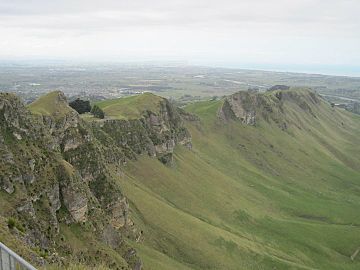
A view from Te Mata Peak
|
|
| Highest point | |
| Elevation | 399 m (1,309 ft) |
| Geography | |
| Climbing | |
| Easiest route | Road |
Te Mata Peak is a special hill in the Hawke's Bay area of New Zealand. It stands tall at 399 meters (about 1,309 feet) above sea level. This peak is south of a town called Hastings.
The town of Havelock North is built right on the lower slopes of Te Mata Peak. It's a popular spot for both locals and visitors.
What is Te Mata Peak?
Te Mata Peak is the highest point in its local area. From the top, you can see amazing views all around. There's a paved road that goes right up to the very top. This makes it easy for everyone to reach the lookout point.
Amazing Views from the Top
Because Te Mata Peak is so high, it offers incredible sights. You can look out over the Heretaunga Plains, which are flat lands below. You can also see the wider Hawke's Bay area, including the city of Napier.
On a clear day, your eyes can even reach further. You might spot Mount Ruapehu, a large volcano far away. You can also see the Mahia Peninsula stretching out into the ocean.
Fun Things to Do
Te Mata Peak is a great place for outdoor activities. Besides driving to the top, there are many trails. These trails are perfect for people who love to hike. They are also popular with mountain bikers looking for an adventure.
Beneath the peak, you can find the Craggy Range vineyard. The Tukituki River also flows nearby. These add to the beautiful scenery around Te Mata Peak.
 | William Lucy |
 | Charles Hayes |
 | Cleveland Robinson |


