
Mount Ruapehu facts for kids

Mount Ruapehu, also known as Ruapehu, is an active stratovolcano in New Zealand. It's located at the southern end of the Taupo Volcanic Zone. This huge mountain is about 23 km (14 miles) northeast of Ohakune. It's also about 23 km (14 miles) southwest of the southern shore of Lake Taupō. Ruapehu is part of Tongariro National Park. The North Island's main ski resorts and only glaciers are found on its slopes.
Ruapehu is the biggest active volcano in New Zealand. It's also the highest point on the North Island. It has three main peaks: Tahurangi (2,797 meters), Te Heuheu (2,755 meters), and Paretetaitonga (2,751 meters). Between these peaks is a deep, active crater. This crater fills with water between big eruptions, forming a lake.
Contents
About Ruapehu
Ruapehu is right in the middle of New Zealand's North Island. It's a huge volcano, estimated to be about 110 cubic kilometers in size. The area around the volcano is covered in volcanic material. This includes lahar deposits, ash, and debris from landslides.
You can reach Ruapehu through three main routes. Each route leads to one of the three ski fields on its slopes. State Highway 48 goes to Whakapapa Village. From there, a road leads up to Iwikau Village. This is at the base of the Whakapapa skifield on the northwest side. Another road from Ohakune leads to Turoa skifield on the southwest side. A four-wheel drive track from the Desert Road (State Highway 1) takes you to the Tukino skifield on the eastern slopes.
Crater Lake and Rivers
Ruapehu's active crater is called Crater Lake (Te Wai ā-moe). It's located at the southern end of the Summit Plateau. As the name suggests, it's filled with a warm, acidic lake. Water from the lake flows into the Whangaehu River. This river is known for dangerous lahars. Lahars are like fast-moving mudslides made of volcanic ash and water.
In the past, eruptions have built natural dams across the lake's outlet. These dams block the water. When they break, they cause huge lahars to rush down the river. This happened in 1953 and 2007. The 1953 lahar caused the Tangiwai disaster. A train bridge collapsed, and many lives were lost. Even bigger lahars happened in 1862 and 1895.
Glaciers on Ruapehu
Ruapehu has 18 glaciers, and six of them have names. Two glaciers are inside the active crater. These are New Zealand's only crater glaciers. Most of the ice on Ruapehu is in three main glaciers: Whangaehu, Summit Plateau, and Mangatoetoenui. The Summit Plateau glacier is actually a thick ice field. It fills an old volcanic crater and is over 130 meters thick.
The Whangaehu glacier feeds the Whangaehu River. The Mangatoetoenui glacier is a main source of the Waikato River. This river starts as small streams on Ruapehu's eastern slopes. On the western side, many streams like the Whakapapa and Manganui o te Ao rivers feed the Whanganui River.

Ruapehu's glaciers are at the northern edge where permanent ice can form in New Zealand. This means they are very sensitive to climate changes. Studies since 1955 show that most glaciers are getting thinner and shrinking. Only the northern crater glacier grew after the 1953 Crater Lake outburst.
Ruapehu's Climate
The upper parts of Ruapehu have a polar tundra climate. This means average temperatures range from -4 to 15°C in summer. In winter, they are between -7 and 7°C. The lower slopes have a subpolar oceanic climate.
Winds usually come from the west or northwest. Strong winds are common on the mountain. The western side of Ruapehu gets more rain than the eastern side. This is because of a "rain shadow" effect. Whakapapa Village gets about 2,200 mm of rain each year. The Rangipo Desert to the east gets a bit more than 1,500 mm. Snow usually falls as low as 1,500 meters.
| Climate data for Iwikau Village (at the base of Whakapapa skifield), altitude 1,626 m | |||||||||||||
|---|---|---|---|---|---|---|---|---|---|---|---|---|---|
| Month | Jan | Feb | Mar | Apr | May | Jun | Jul | Aug | Sep | Oct | Nov | Dec | Year |
| Mean daily maximum °C (°F) | 16.6 (61.9) |
16.5 (61.7) |
14.8 (58.6) |
11.7 (53.1) |
8.7 (47.7) |
6.0 (42.8) |
5.1 (41.2) |
5.8 (42.4) |
8.0 (46.4) |
9.8 (49.6) |
12.2 (54.0) |
14.4 (57.9) |
10.8 (51.4) |
| Daily mean °C (°F) | 11.9 (53.4) |
12.0 (53.6) |
10.4 (50.7) |
7.7 (45.9) |
5.2 (41.4) |
2.9 (37.2) |
1.9 (35.4) |
2.2 (36.0) |
4.0 (39.2) |
5.5 (41.9) |
7.6 (45.7) |
10.0 (50.0) |
6.8 (44.2) |
| Mean daily minimum °C (°F) | 8.1 (46.6) |
8.3 (46.9) |
6.9 (44.4) |
4.7 (40.5) |
2.8 (37.0) |
0.7 (33.3) |
−0.4 (31.3) |
−0.3 (31.5) |
1.1 (34.0) |
2.5 (36.5) |
4.0 (39.2) |
6.6 (43.9) |
3.8 (38.8) |
| Average rainfall mm (inches) | 154 (6.1) |
129 (5.1) |
120 (4.7) |
141 (5.6) |
162 (6.4) |
164 (6.5) |
173 (6.8) |
182 (7.2) |
191 (7.5) |
211 (8.3) |
191 (7.5) |
190 (7.5) |
2,008 (79.2) |
| Average rainy days (≥ 1.0 mm) | 12 | 10 | 10 | 11 | 12 | 12 | 13 | 14 | 14 | 15 | 13 | 14 | 150 |
| Average relative humidity (%) | 77 | 79 | 80 | 86 | 89 | 92 | 89 | 88 | 87 | 85 | 81 | 82 | 85 |
Staying Safe in Bad Weather
Weather on Ruapehu can change very quickly. Visitors should always be ready and carry basic survival gear. Sadly, severe weather has caused several deaths over the years. In 1990, a storm trapped a group of soldiers and a sailor during training. An experienced climber also got trapped but survived by building a snow cave.
Extreme weather has also caused people to get stuck on the mountain. In 2003, about 350 visitors and 70 staff had to stay overnight at Whakapapa skifield. A snowstorm made the road too dangerous to go down. In 2008, about 2,000 visitors were evacuated from the skifield. Cars were led down the mountain in groups, but about 100 cars had to stay overnight.
How Ruapehu Was Formed
Ruapehu is a type of volcano called a composite andesitic stratovolcano. It's part of the Tongariro Volcanic Center. This volcano formed because the Pacific Plate is sliding under the Australian Plate. This process is called subduction.
Ruapehu has erupted from many craters over its long life. But today, only one crater is active. This is the deep crater at the summit, filled with hot, acidic water, known as Crater Lake.
Scientists aren't sure exactly when Ruapehu first started erupting. They know it was at least 250,000 years ago. It might have even been as early as 340,000 years ago! Ruapehu has grown in four main stages of intense eruptions. Each stage was followed by quieter times.

Today, volcanic activity is mostly focused on Crater Lake. There are two active vents, or openings, under the lake. They are called North Vent and Central Vent. The lake's temperature goes up and down every 6-12 months. When it heats up, there are more small earthquakes under the crater. More volcanic gases also escape. This shows that the vents under Crater Lake are open. This open system helps prevent pressure from building up. This is why Ruapehu usually has smaller, more frequent eruptions. They happen about every 20-30 years.
Big eruptions, like in 1945 and 1995–1996, can empty Crater Lake. But it refills after the eruptions stop. Melting snow and steam from the vents help it refill. Sometimes, eruptions create a dam of volcanic ash across the lake's outlet. This stops the lake from overflowing into the Whangaehu River valley. Eventually, these dams collapse, causing a large lahar.
The ash dam from the 1945 eruptions broke on December 24, 1953. This caused the lahar that led to the Tangiwai disaster. A train bridge collapsed, and 151 people died. Another dam formed after the 1995–1996 eruptions. It collapsed on March 18, 2007. A warning system called ERLAWS (Eastern Ruapehu Lahar Alarm and Warning System) was installed in 2000. It detected the 2007 lahar. Roads were closed, and trains stopped until the lahar passed.
Recent Eruptions
For the past 2,000 years, Ruapehu's activity has mainly been through its crater lake. Eruptions are usually small but explosive. They happen every few decades and last for several months. In recorded history, big eruptions have happened about 50 years apart. These were in 1895, 1945, and 1995–1996. Smaller eruptions happen every few years. Notable ones were in 1969, 1975, and 2007. More than 600 eruptions of different sizes have been recorded since 1830.
1945 Eruptions and 1953 Lahar
Ruapehu started erupting in March 1945. This was after several weeks of volcanic tremors. Ash was seen falling on the eastern slopes on March 8. A lava dome was seen in Crater Lake on March 19. But it was destroyed by explosive eruptions over the next week. A second, bigger lava dome appeared in May. It grew over the next few months and emptied Crater Lake by July.
Eruptions got stronger from August to November. A very powerful eruption on August 21 was heard far away. Eruptions started to decrease in December and ended by January.
The eruptions spread ash across most of the North Island. Ash clouds could be seen from far away cities. Ash caused problems for many communities. It got into houses, caused eye and throat irritation, and damaged car paint. Crops were damaged in Ohakune, and the water supply in Taumarunui was affected.
After the eruptions stopped, Crater Lake slowly refilled. A "boiling lake" was already forming by mid-January. The eruptions had created an ash dam at the lake's outlet. This dam eventually collapsed on December 24, 1953. This caused a lahar that led to the Tangiwai disaster. 151 people died when the Tangiwai railway bridge collapsed just as an express train was crossing it.
1969 and 1975 Eruptions
Ruapehu was very active between 1966 and 1982. Many small eruptions happened in Crater Lake. Two larger eruptions in 1969 and 1975 threw rocks across the summit. They also produced significant lahars.
The 1969 eruption happened on June 22. It was a moderate eruption that blasted rocks up to 1 km (0.6 miles) from the crater. It sent lahars down several valleys. The Whakapapa skifield was covered in mud. This was the biggest eruption since 1945.
A larger eruption happened on April 24, 1975. It blasted rocks up to 1.6 km (1 mile) from the crater. Ash fell more than 100 km (62 miles) to the southeast. Nearly half of the water in Crater Lake was thrown into the air. This water then rained down on the summit, creating lahars. These lahars damaged ski lifts and bridges. They also poisoned the Whanganui River, harming aquatic life. Luckily, no one died.
Three days later, on April 27, Ruapehu erupted again. Several eruptions sent mud, rocks, and ash across the summit plateau. They also created eruption columns up to 500 meters (1,640 feet) high. The 1975 eruptions made Crater Lake much deeper.
1995–1996 Eruptions
Earthquakes near Ruapehu in 1994 and 1995 showed that the volcano was becoming active again. The temperature of Crater Lake rose quickly. It reached 51.4°C (124.5°F) in January 1995. This was one of the highest temperatures in 30 years. Minor eruptions happened in April and June. They damaged monitoring equipment and produced a lahar. Scientists found that magma was mixing with water under the lake.
The first big eruption happened on September 18, 1995. It rained ash onto the summit and sent lahars down the mountain. On September 23, an even larger eruption blasted rocks far away. It sent lahars down three valleys and created an ash column 12 km (7.5 miles) high. Explosive eruptions continued through October. Ash fell up to 250 km (155 miles) away. On October 11, explosive eruptions emptied Crater Lake.

Activity then quieted down until June 15, 1996. New earthquakes were recorded. This was followed by eruptions on June 17 and 18. These eruptions once again emptied the partially refilled Crater Lake. Strombolian eruptions happened in June, July, and August. They produced ash columns over 10 km (6.2 miles) high. They also shot rocks 1.4 km (0.9 miles) from the crater.
These eruptions produced over 7 million tons of ash. This ash contaminated water supplies, destroyed crops, and killed livestock. Ash in the Tongariro River damaged power station turbines. Ash clouds also caused airports to close in Auckland and Wellington. The eruptions also closed the three ski fields. This cost the region an estimated $100 million in lost money.
After the 1996 eruption, people realized that a huge lahar could happen again. This would be when Crater Lake burst the volcanic ash dam, just like in 1953. So, in 2000, the Eastern Ruapehu Lahar Alarm and Warning System (ERLAWS) was installed. This system detects a dam collapse and warns authorities. The lake slowly refilled with melted snow. It reached the level of the hard rock rim by January 2005. The lahar finally happened on March 18, 2007.
2006 and 2007 Activity
Ruapehu erupted on October 4, 2006, at 10:24 p.m. It was a small eruption. It caused a magnitude 2.9 volcanic earthquake. Waves 4–5 meters (13–16 feet) tall crashed into the crater wall. No ash was erupted into the air. The eruption is thought to have happened entirely underwater.

Current Activity and Future Dangers
Only one eruption has been recorded at Ruapehu since 2007. This was a small event on July 13, 2009. A small volcanic earthquake under Crater Lake caused the lake level to rise 15 cm (6 inches). It also triggered a snow slurry lahar in the upper Whangaehu valley. Since then, Crater Lake has continued its regular heating and gas release cycles. There have been periods of very high temperatures in 2011, 2016, and 2019.
Eruptions at Ruapehu are expected to continue like they have for the past 2,000 years. This means frequent small eruptions and bigger events every 20–30 years. However, even larger events are still possible. Small eruptions, especially those caused by water and steam, can happen at any time without warning. But big eruptions usually only happen during periods of increased activity.
The main danger from Ruapehu today is from lahars. Two major lahar paths go through the Whakapapa skifield. Lahars have traveled through the ski field in 1969, 1975, 1995, and 2007. There is an eruption warning system at the ski field to warn skiers. Lahars are also a big danger to nearby river valleys. Especially the Whangaehu River, which has highways, a railway line, and power lines crossing it. Large, destructive lahars have been seen in the Whangaehu River in 1862, 1895, 1953, 1975, and 2007.
GNS Science constantly watches Ruapehu. They use seismographs, GPS stations, microphones, and webcams. They also regularly test the water in Crater Lake and measure gases from the air. You can see live data on the GeoNet website.
Ski Fields

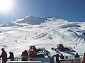
Ruapehu has two main ski fields: Whakapapa on the northern side and Turoa on the southern side. They are the two largest ski fields in New Zealand, with Whakapapa being bigger. The club field Tukino is on the eastern side and is open to the public. The ski season usually runs from June to October. This depends on how much snow there is and the weather.
Both ski fields can be reached by car. They also have chairlifts. There are slopes for beginners to advanced skiers. Whakapapa has five chairlifts. You can find some places to stay and eat at Top o' the Bruce (the car park) and at the entrance to Whakapapa. There are also alpine huts for hikers and climbers. These are mostly owned by private clubs.
In Popular Culture
Some scenes from the fictional lands of Mordor and Mount Doom were filmed on the slopes of Mount Ruapehu. These were for Peter Jackson's The Lord of the Rings film trilogy.
See also
 In Spanish: Ruapehu para niños
- List of mountains of New Zealand by height
- List of volcanic eruptions by death toll
- List of volcanoes in New Zealand
- Volcanism of New Zealand
Images for kids
-
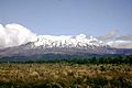
Mount Ruapehu, January 2002.
-
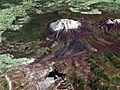
A composite satellite image looking west across Ruapehu, with the older eroded volcano Hauhungatahi visible behind it, and the cone of Ngauruhoe visible to the right.
-
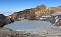
Crater Lake and Tahurangi, the highest peak (top right) in 2016. The 1996 tephra dam is the bluish dark area at lake edge directly below Tahurangi.
-
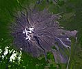
Fresh lahar channels scar Ruapehu's eastern slopes, 2007.
-
Turoa ski field.
-
View of Mount Ruapehu from close to the summit of Mount Taranaki

