Ohakune facts for kids
Quick facts for kids
Ohakune
|
|
|---|---|
|
Minor urban area
|
|
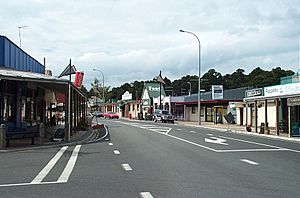
Main street of Ohakune
|
|
| Country | New Zealand |
| Region | Manawatū-Whanganui |
| District | Ruapehu District |
| Ward |
|
| Community | Waimarino-Waiouru Community |
| Electorates |
|
| Area | |
| • Total | 6.44 km2 (2.49 sq mi) |
| Elevation | 582 m (1,909 ft) |
| Population
(June 2023)
|
|
| • Total | 1,510 |
| • Density | 234.5/km2 (607.3/sq mi) |
| Time zone | UTC+12 (NZST) |
| • Summer (DST) | UTC+13 (NZDT) |
| Postcode |
4625
|
| Telephone | 06 |
Ohakune is a small town in the North Island of New Zealand. It sits at the southern edge of Tongariro National Park. The town is also very close to the active volcano Mount Ruapehu.
Ohakune is known as New Zealand's Carrot Capital because of its farming. In winter, it's a popular spot for skiers heading to the ski fields on Mount Ruapehu, especially Turoa. In summer, many people use Ohakune as a base for hiking the famous Tongariro Alpine Crossing.
Contents
- What's in a Name? The Meaning of Ohakune
- Ohakune's Past: A Look at Its History
- Ohakune's Location: Where is it?
- Ohakune's Weather
- Who Lives in Ohakune? Population Facts
- Ohakune's Economy: How the Town Makes Money
- What Ohakune Offers: Facilities and Media
- Fun in Ohakune: Recreation and Events
- Famous Spots: Ohakune's Landmarks
- Learning in Ohakune: Schools
- Getting Around: Transportation in Ohakune
- Famous People from Ohakune
What's in a Name? The Meaning of Ohakune
The local Ngāti Rangi iwi (tribe) explains that the Māori language name Ohakune comes from a special phrase. This phrase, "he Ohakune ki te ao", means "an opening to a new world." It describes coming down from Mount Ruapehu into the valley and wetlands of the area.
In 2019, the New Zealand Geographic Board tried to change the name to Ōhakune. This change would have shown that the first 'O' sound is long. However, Ngāti Rangi didn't agree, so the name quickly went back to Ohakune without the long vowel mark.
Ohakune's Past: A Look at Its History
Early Māori Life in Ohakune
For a long time, the Māori people of the Ngāti Rangi iwi lived in the lands south and west of Mount Ruapehu.
Around the mid-1600s, a marae (a meeting place for Māori) in Rangataua was attacked. This small town is about five kilometres south-east of Ohakune. People from the Ngāti Raukawa iwi, from further east, drove the inhabitants from their homes. About 75 people were killed. The few survivors fled and built a new fortified village, called a pā, where Ohakune is today.
How Ohakune Grew
In 1879, the Crown (the New Zealand government) bought a large area of Māori land in Ohakune.
In 1883, engineers started planning the North Island Main Trunk Railway. They set up a base where Ohakune is now. This soon became a permanent camp for railway and road builders. People started settling in the town in the early 1890s. In 1893, many land sections were sold. Before the railway reached Ohakune, all supplies had to be brought in by cart or by river.
By March 1908, the railway line finally reached Ohakune. After the railway was built, people started cutting down trees for timber. As the forests were cleared, farmers brought in cattle and sheep. Ohakune officially became a town district in 1908 and a borough (a type of town) in 1911.
A special railway line to Raetihi opened in 1917 but closed in 1968. A old bridge from this line is still standing near the Big Carrot. In 1918, a big fire happened in Raetihi. A train from Ohakune helped rescue hundreds of people. Many were temporarily blinded by smoke and had to hide in waterways.
From the early 1900s, Chinese gardeners started growing vegetables in Ohakune. The soil here is very good for farming. They would lease land that had just been cleared of trees. They improved the soil and grew crops like oats, root vegetables, and cabbages. After a few years, grass would be planted, and the land would go back to its owners. The gardeners would then move to a new spot. By 1939, about 20 Chinese market gardeners were working in Ohakune. By 1941, Ohakune and the surrounding area produced almost half of the North Island's vegetables.
In January 1942, a serious flood hit Ohakune, and one person died. Both rivers in the town overflowed. Topsoil from gardens was washed away, and a lot of mud and wood from logging was left on the streets. People believed the floods were worse because native forests on Mount Ruapehu had been cut down, causing soil to wash away easily.
After the Raetihi railway line closed, the land near Ohakune was used as a caravan park for skiers visiting the new Turoa ski field. This land later became the home of the Big Carrot and Carrotland.
Marae: Important Meeting Places
Ohakune has two marae. A marae is a special place for Māori people to gather, hold meetings, and celebrate important events.
- Maungārongo Marae and its meeting house, Tikaraina Ringapoto or Ko Te Kingi o Te Maungārongo, are used by the Ngāti Rangi hapū (sub-tribe) of Ngāti Tui-o-Nuku.
- Ngā Mōkai Marae and its meeting house, Whakarongo, are used by the Ngāti Rangi hapū of Ngāti Tongaiti.
In 2020, the government provided money to upgrade seven marae, including Maungārongo Marae. This project helped create 95 jobs.
Ohakune's Location: Where is it?
Ohakune is in the Ruapehu District and the Manawatū-Whanganui region. It is located just southwest of the slopes of the Mount Ruapehu stratovolcano (a cone-shaped volcano). The Ohakune volcanic area is just north of the town. Small lakes called Rangatauanui and Rangatauaiti are south of the town.
Ohakune is about 25 kilometres west of Waiouru and 70 kilometres northeast of Whanganui. It is also about 287 kilometres north of Wellington and 292 kilometres south of Auckland. The town sits at an elevation of 582 metres (about 1,909 feet) above sea level.
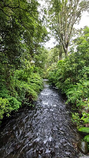
The Mangateitei Stream flows through the town from east to west. It joins the Mangawhero River, which flows south from near the railway station before turning west.
Ohakune's Weather
| Climate data for Ohakune, elevation 607 m (1,991 ft), (1991–2020) | |||||||||||||
|---|---|---|---|---|---|---|---|---|---|---|---|---|---|
| Month | Jan | Feb | Mar | Apr | May | Jun | Jul | Aug | Sep | Oct | Nov | Dec | Year |
| Record high °C (°F) | 31.1 (88.0) |
30.7 (87.3) |
28.0 (82.4) |
26.0 (78.8) |
22.0 (71.6) |
19.1 (66.4) |
17.4 (63.3) |
18.8 (65.8) |
21.3 (70.3) |
25.0 (77.0) |
27.8 (82.0) |
29.0 (84.2) |
31.1 (88.0) |
| Mean daily maximum °C (°F) | 21.8 (71.2) |
22.0 (71.6) |
19.7 (67.5) |
16.2 (61.2) |
13.2 (55.8) |
10.6 (51.1) |
9.7 (49.5) |
10.8 (51.4) |
12.6 (54.7) |
14.8 (58.6) |
17.2 (63.0) |
19.9 (67.8) |
15.7 (60.3) |
| Daily mean °C (°F) | 15.7 (60.3) |
16.0 (60.8) |
13.8 (56.8) |
11.1 (52.0) |
8.6 (47.5) |
6.5 (43.7) |
5.6 (42.1) |
6.5 (43.7) |
8.1 (46.6) |
10.1 (50.2) |
11.7 (53.1) |
14.4 (57.9) |
10.7 (51.2) |
| Mean daily minimum °C (°F) | 9.6 (49.3) |
10.0 (50.0) |
7.9 (46.2) |
6.0 (42.8) |
4.1 (39.4) |
2.4 (36.3) |
1.6 (34.9) |
2.1 (35.8) |
3.7 (38.7) |
5.3 (41.5) |
6.1 (43.0) |
8.8 (47.8) |
5.6 (42.1) |
| Record low °C (°F) | −1.0 (30.2) |
−0.6 (30.9) |
−3.3 (26.1) |
−3.5 (25.7) |
−6.7 (19.9) |
−10.0 (14.0) |
−7.0 (19.4) |
−5.9 (21.4) |
−6.7 (19.9) |
−4.5 (23.9) |
−4.0 (24.8) |
−1.0 (30.2) |
−10.0 (14.0) |
| Average rainfall mm (inches) | 97.5 (3.84) |
72.7 (2.86) |
74.9 (2.95) |
111.2 (4.38) |
113.6 (4.47) |
128.7 (5.07) |
148.6 (5.85) |
121.5 (4.78) |
137.8 (5.43) |
128.4 (5.06) |
117.6 (4.63) |
104.3 (4.11) |
1,356.8 (53.43) |
| Mean monthly sunshine hours | 267.6 | 198.6 | 195.3 | 156.3 | 126.4 | 101.0 | 111.6 | 125.5 | 142.1 | 167.6 | 227.8 | 236.6 | 2,056.4 |
| Source: NIWA | |||||||||||||
Who Lives in Ohakune? Population Facts
Ohakune covers an area of 6.44 square kilometres. As of 2018, about 1,182 people lived there. This means there were about 184 people per square kilometre.
| Historical population | ||
|---|---|---|
| Year | Pop. | ±% p.a. |
| 2006 | 1,095 | — |
| 2013 | 984 | −1.52% |
| 2018 | 1,182 | +3.73% |
In 2018, Ohakune's population had grown by 20.1% since 2013. There were more males (621) than females (561). The average age was 36.1 years. About 19% of the people were under 15 years old.
Most people in Ohakune (69.8%) are of European background. About 34.8% are Māori. Smaller groups include Pacific peoples (2.3%) and Asian (7.9%).
Many people (53.6%) said they had no religion. About 29.2% were Christian. Some people followed Māori religious beliefs (4.8%) or other religions.
Most people aged 15 or older (55.2%) worked full-time. About 15% worked part-time, and 4.1% were unemployed.
Ohakune's Economy: How the Town Makes Money
Ohakune's economy is mostly based on services. In 2021, the town's total economic output was $74 million. This was about 10% of the total for the whole Ruapehu District.
The biggest parts of Ohakune's economy are:
- Retail trade (shops)
- Arts and recreation services (like ski resorts and adventure activities)
- Accommodation and food services (hotels, restaurants)
These areas also provide the most jobs.
Ohakune is famous for its carrots. In 2017, the Manawatū-Whanganui region, where Ohakune is, was the second-largest carrot producer in New Zealand. Two-thirds of the North Island's carrots came from Ohakune. However, by 2023, carrot growers faced challenges. The cost of fuel, fertiliser, and other supplies increased. It also became harder to find staff and pay wages. This made some growers wonder if their businesses could continue.
What Ohakune Offers: Facilities and Media
Ohakune has many services found in a typical small New Zealand town. In 2015, these included a dental clinic, pharmacy, fire station, and police station. There are also churches and a marae with a district nurse. For more medical care, the nearest centre with a doctor and nurses is 11 kilometres away in Raetihi.
Local News and Radio
Ohakune is covered by the Whanganui Chronicle, a daily newspaper. Ski FM Network broadcasts from Ohakune on 91.8 FM. This radio station provides information about snow levels in the region during winter.
Fun in Ohakune: Recreation and Events
Ohakune is a great place for outdoor activities. You can enjoy snow sports, trout fishing, mountain biking, and hiking.
Winter Sports and Activities
Ohakune offers easy access to the Mount Ruapehu ski fields. Turoa is the closest ski resort to Ohakune. Whakapapa is another large commercial resort. There's also a smaller club field called Tukino. You can rent ski gear and buy lift tickets in town.
Ohakune has sports clubs, including the Ruapehu Rugby & Sports Club.
Summer Adventures
In summer, Ohakune is perfect for many activities. Hikers can access the famous Tongariro Alpine Crossing. You can also rent mountain bikes in town.
Water activities are popular on nearby rivers. You can go jet boating on the Whanganui River or rafting on the Whanganui, Rangitikei, and Tongariro rivers. Trout fishing is available in nearby lakes and rivers, including the well-known Tongariro River.
The Bridge to Nowhere in the Whanganui National Park is a popular spot for hikers and mountain bikers. It's located between Ohakune and Whanganui.
Exciting Events in Ohakune
The Carrot Carnival has been held in Ohakune since 1996. It started after Mount Ruapehu erupted in 1995 and 1996, and there were several years of low snowfall. These events caused the local economy to shrink. The carnival was created to attract visitors back to the town. It features games, competitions between growers, carrot-themed foods, and family-friendly attractions.
The Ohakune Mardi Gras also began in 1996. It was another way to bring visitors to the town after the volcano eruptions. It's a ski party and a celebration of winter, with musicians, stalls, and rides. The event was cancelled in 2017 but came back in 2018 as an event for people aged 18 and over.
The Big Mountain Short Film Festival has been held since 2006. It's a free festival that shows short films. It also features speakers who share tips on making low-budget films and telling stories.
Famous Spots: Ohakune's Landmarks
The Big Carrot and Carrotland
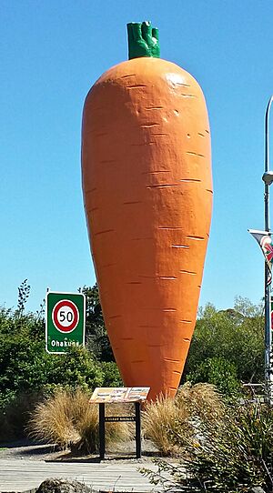
On the eastern edge of Ohakune, you'll find a huge 7.5-metre-high replica of a carrot. This is known as 'The Big Carrot'. It's said to be the world's largest model carrot! It was first built as a prop for a TV advertisement in the early 1980s. After filming, the carrot was given to the town in 1984. This was to celebrate Ohakune's fame as a major carrot-growing area. In 2011, the carrot was painted black for the 2011 Rugby World Cup.
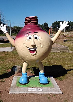
Carrot Adventure Park, also called Carrotland, opened next to the Big Carrot in 2016. The park has a playground with a carrot-shaped car. It also features fibreglass vegetable characters, like a swede, a potato, a Brussels sprout, and a parsnip. These represent the different crops grown in Ohakune. The park has information boards about the district's history of market gardens and forestry. There are also picnic spots, an obstacle course, and a BMX track. In 2023, a carrot-shaped space rocket was added to the park. This rocket was largely funded by YouTubers Joshua Carrott and Oliver Kendal. Joshua Carrott felt a special connection to the Big Carrot and wanted to support the park.
War Memorial Gate
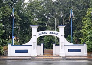
Ohakune has a war memorial that looks like a large arched gate. It's located on Clyde Street at the entrance to Jubilee Park. The memorial was opened in 1932. It has marble tablets listing the names of 26 men from the district who died in World War 1. Later, another tablet was added for those who died in World War 2.
Railway Station and Signal Box
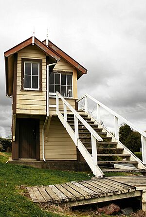
The Ohakune railway station was built around 1908 as part of the North Island Main Trunk railway. It is one of the oldest buildings in Ohakune. The town's original railway signal box was taken down years ago. However, in 1991, a signal box from Paekākāriki Station was moved to Ohakune. It was restored to celebrate Ohakune's railway history. The station building and signal box were recognised as a Historic Place in 2009. A local resident, Bob Norling, received an award in 2020 for his work in restoring the station. Near the station, there is also a small railway museum.
Weather Rock
In the 1980s and 90s, Ohakune had a fun landmark called the Weather Rock on Thames Street. Tourists loved taking photos with it. The rock would "forecast" the weather with a sign that had funny sayings like: "If rock is hot – sunny," "If rock is wet – raining," and "If rock is bouncing – earthquake."
Learning in Ohakune: Schools
Ohakune has three schools for students:
- Ohakune School is a state primary school for students in Years 1 to 8. It has 237 students.
- Ruapehu College is a state secondary school for students in Years 9 to 13. It has 251 students.
- Te Kura Kaupapa Māori o Ngati Rangi is a state Kura Kaupapa Māori. This school teaches in the Māori language for students in Years 1 to 8. It has 43 students.
Getting Around: Transportation in Ohakune
Road Travel
State Highway 49 passes through Ohakune. In town, it is known as Clyde Street.
Ohakune is also part of the Intercity coach (bus) network. Buses run north to Auckland and south to Palmerston North.
Train Travel
Ohakune is on the North Island Main Trunk Railway. The railway station is in the Ohakune Junction area, about 2.5 kilometres from the town centre. Ohakune railway station is the second highest operating railway station in New Zealand. A sign at the station says it is 618.4 metres (2,029 feet) above sea level.
Passenger train services are run by KiwiRail under its Great Journeys New Zealand division. The Northern Explorer train travels between Auckland and Wellington. The journey to or from Auckland crosses the famous Raurimu Spiral, a special railway track design.
About 17 kilometres east of Ohakune is the Tangiwai Bridge. This was the site of New Zealand's worst railway accident, the Tangiwai Disaster, which happened on December 24, 1953.
Famous People from Ohakune
Some notable people who have lived in or are connected to Ohakune include:
- Erwin Leonard Guy Abel – a grocer, businessman, athlete, and racehorse owner.
- Jeff Bollow – who helped start the Big Mountain Short Film Festival.
- Martin Edmond – an author and screenplay writer.
- Pat Mackie – a miner and union leader, born in Ohakune in 1914.
- Mick Moohan – a member of the Ohakune Borough Council and later a Labour Party MP and Minister.
- William Taylor – a primary school principal, Mayor of Ohakune, and a writer.
- Peter Williams – a lawyer and advocate for prison reform.
 | Jewel Prestage |
 | Ella Baker |
 | Fannie Lou Hamer |


