Bridge to Nowhere (New Zealand) facts for kids
Quick facts for kids Bridge to Nowhere |
|
|---|---|

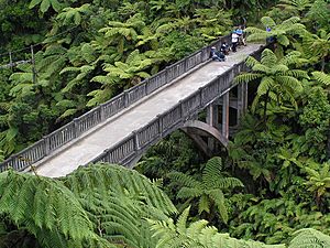
The Bridge to Nowhere from the access path
|
|
| Coordinates | 39°16′15.31″S 174°58′19.88″E / 39.2709194°S 174.9721889°E |
| Carries | Footbridge |
| Crosses | Mangapurua Stream |
| Locale | Mangapurua Valley, Whanganui National Park, North Island, New Zealand |
| Characteristics | |
| Design | Arch bridge |
| Material | Concrete |
| Width | Single lane |
| Height | 40 metres (130 ft) |
| Longest span | 34.1 metres (112 ft) |
| History | |
| Designer | The Public Works Department |
| Constructed by | Sandford and Brown |
| Construction begin | January 1935 |
| Construction end | June 1936 |
The Bridge to Nowhere is a unique concrete bridge found deep inside Whanganui National Park in New Zealand. What makes it special? It has no roads leading to it! This makes it a popular spot for adventurers. People hike, bike, or kayak to see this historic landmark.
Contents
A Bridge to a Forgotten Past
The Bridge to Nowhere was built a long time ago, between 1935 and 1936. It crosses the deep Mangapurua Gorge. The government wanted to open up land here for farming. This was mainly for soldiers who had returned from World War I. The plan was to build roads to the bridge later on.
Why Was It Built?
The bridge was meant to help farmers connect with the Whanganui River. Riverboats could then take their goods to other places. In 1917, the government offered land in the Mangapurua Valley. Many soldiers from World War I decided to try farming there. They cleared the thick forest and set up about 35 farms. A school was even opened for the children. For some years, the valley seemed to be doing well.
The Valley's Story
Life in the Mangapurua Valley was very hard. The area was very remote and difficult to reach. Farmers faced tough economic times. Because of these problems, many families started to leave their farms. By 1942, only three families were left in the valley. After a big flood in January 1942, the government stopped funding road repairs. They officially closed the valley in May 1942.
Today, you can still see signs of the past. Old fence lines, patches of non-native trees, and even old chimneys remain. The Bridge to Nowhere is the most famous reminder. It shows the story of a settlement that didn't quite work out. The name Mangapūrua means "abundant stream" in the Māori language.
How to Visit the Bridge
Even though it has no roads, the Bridge to Nowhere is a popular tourist spot. You can reach it in a few ways. Some people ride mountain bikes along special tracks. Others enjoy tramping, which is like hiking, on different trails. You can also get there by boat or kayak. After a boat trip, it's about a 45-minute walk through the bush to reach the bridge.
See also
 | Janet Taylor Pickett |
 | Synthia Saint James |
 | Howardena Pindell |
 | Faith Ringgold |

