
Whanganui River facts for kids
Quick facts for kids Whanganui River |
|
|---|---|

The Whanganui River. Mount Ruapehu can partly be seen at the top right of the scene.
|
|

The Whanganui River system
|
|
| Native name | Whanganui |
| Country | New Zealand |
| Region | Manawatū-Whanganui |
| Towns and cites | Taumarunui, Whanganui |
| Physical characteristics | |
| Main source | Mount Tongariro |
| River mouth | Tasman Sea Sea level 39°56.89′S 174°59.22′E / 39.94817°S 174.98700°E |
| Length | 290 km (180 mi) |
| Basin features | |
| Basin size | 7,380 km2 (2,850 sq mi) |
| Tributaries |
|
The Whanganui River is a very important river located on the North Island of New Zealand. It is the third longest river in the country. This river holds a special place in the hearts of the Māori people who live in the region.
In March 2017, the Whanganui River made history. It became the second natural place in the world (after Te Urewera) to be given its own legal identity. This means the river is now treated like a living person in the eyes of the law. It has its own rights, duties, and responsibilities. This special agreement, called the Whanganui Treaty settlement, finally ended the longest-running legal case in New Zealand's history.
Contents
Exploring the Whanganui River's Geography
The Whanganui River stretches for about 290 kilometers (180 miles), making it New Zealand's third longest river. A large part of the land around the upper sections of the river is part of the Whanganui National Park. However, the river itself is not inside the park's boundaries.
The river begins high up on the northern slopes of Mount Tongariro. This mountain is one of three active volcanoes on the central plateau, and it's close to Lake Rotoaira. The river first flows northwest before turning southwest when it reaches Taumarunui.
From Taumarunui, the river winds through hilly areas covered in thick bush, known as the King Country. It then turns southeast, passing small towns like Pipiriki and Jerusalem. Finally, it reaches the coast at Whanganui city, where it flows into the Tasman Sea. The Whanganui River is one of the longest rivers in New Zealand that boats can travel on.
In 1843, an earthquake in the Wanganui area changed the river valley. Later, in the 1970s, a small eruption from Mount Ruapehu caused some toxic water from its crater lake to spill into the Whanganui River. This pollution sadly killed many fish downstream, including large eels and trout. A lahar (a type of mudflow) from Ruapehu in 1975 also affected the Whakapapa River, a tributary, causing fish losses there too.
Understanding the River's Tributaries
Many smaller rivers and streams flow into the Whanganui River, adding to its size and power. These are called tributaries. Here are some of the main ones:
| Tributary name | Length (km) | Km from mouth | Confluence coordinates | Altitude |
|---|---|---|---|---|
| Mount Tongariro | River source | 290 km | 39°07.91′S 175°37.95′E / 39.13183°S 175.63250°E | |
| Whakapapa River | 65 km (40 mi) | 38°55′48″S 175°24′28″E / 38.93000°S 175.40778°E | 255 m (837 ft) | |
| Pungapunga River | 22 km (14 mi) | 38°53′30″S 175°20′0″E / 38.89167°S 175.33333°E | 172 m (564 ft) | |
| Ongarue River | 73 km (45 mi) | 38°53′31″S 175°15′11″E / 38.89194°S 175.25306°E | 144 m (472 ft) | |
| Ohura River | 39°02′20″S 175°3′52″E / 39.03889°S 175.06444°E | 114 m (374 ft) | ||
| Retaruke River | 39°06′9″S 175°4′12″E / 39.10250°S 175.07000°E | 108 m (354 ft) | ||
| Tangarakau River | 26 km (16 mi) | 39°14′17″S 174°52′52″E / 39.23806°S 174.88111°E | 85 m (279 ft) | |
| Whangamōmona River | 22 km (14 mi) | 39°16′17″S 174°53′23″E / 39.27139°S 174.88972°E | 82 m (269 ft) | |
| Manganui o te Ao River | 32 km (20 mi) | 39°24′18″S 175°2′42″E / 39.40500°S 175.04500°E | 62 m (203 ft) | |
| Tasman Sea | River mouth | 0 km | 39°56.89′S 174°59.22′E / 39.94817°S 174.98700°E | 0 m |
The Whanganui River's Rich History

Māori legends tell amazing stories about how the Whanganui River was formed. One legend says that when Mount Taranaki moved away from the central plateau towards the coast, it split the land open. The river then filled this new gap.
Another Māori legend explains that after Māui caught the giant fish that became the North Island of New Zealand, he prayed to Ranginui. Ranginui then sent two teardrops that landed on Māui's fish, forming the Whanganui and Waikato rivers.
According to Māori tradition, the river was first explored by Tamatea. He was one of the leaders who first migrated to New Zealand. He traveled up the river all the way to Lake Taupō. Many places along the river are named in his honor.
The Whanganui River was a very important travel route to the center of the North Island. It was used by both Māori and later by European settlers. Even though it had many white water sections and over 200 rapids, it was crucial for transport. Before Europeans arrived, the area around the Whanganui was home to many Māori villages. When colonial settlers came, the area near the river's mouth became a major trading spot.
The river became even more important for trade thanks to Alexander Hatrick. He started the first regular steamboat service in 1892. This service eventually went all the way to Taumarunui, where people could connect to trains and coaches going further north. One of Hatrick's original boats, the paddle-steamer PS Waimarie, has been restored. You can still take trips on it in Whanganui. Another Hatrick boat, MV Wairua, has also been restored and can be seen on the river.
In the early 1900s, the Whanganui River (then called Wanganui River) was one of New Zealand's top tourist spots. Its wild beauty and the Māori villages (called kāinga) along its banks attracted thousands of visitors each year.
When the North Island Main Trunk railway was finished, the steamboat route to the north became less needed. The main economic activity in the river area then shifted to forestry. In the 1930s, people tried to turn the river valley into farmland, but it wasn't successful. A lasting reminder from that time is the Bridge to Nowhere. It was built to give access to settlements that were later abandoned.
In 1912–13, a French filmmaker named Gaston Méliès made a documentary film about the river. He called it The River Wanganui and described it as "the Rhine of New Zealand." Sadly, this film is now lost.
The settlement of Jerusalem is a special place along the river. It was home to two famous New Zealanders: Mother Mary Joseph Aubert, who started a Catholic mission there that still exists, and poet James K. Baxter, who created a community there in 1970. Other settlements along the river include Tieke Kāinga, Pipiriki, Rānana, Matahiwi, and Koriniti.
The River's Special Status: Taonga and Legal Rights
The Whanganui River is incredibly important and spiritual for Māori people. They also call it Te awa tupua, meaning "the sacred river." Before Europeans arrived, many Māori villages were located along its banks. Because of this, the river is considered a taonga, which means a special treasure. Recently, efforts have been made to protect the river and treat it with the respect it deserves.
For these reasons, the river has been a central point in land claims brought before the Waitangi Tribunal. These claims seek the return of tribal lands. The Whanganui River claim is known as the longest-running legal case in New Zealand's history. It involved petitions and court actions in the 1930s, Waitangi Tribunal hearings in the 1990s, the ongoing Tieke Marae land occupation since 1993, and the well-known Moutoa Gardens occupation in 1995.
On August 30, 2012, an agreement was reached to give the Whanganui River a legal identity. This was a world first! Then, on March 15, 2017, this agreement became law in the New Zealand Parliament. Chris Finlayson, the Minister for Treaty of Waitangi Negotiations, explained that the river would have an identity "with all the corresponding rights, duties and liabilities of a legal person." He said some people might find it strange, but it's "no stranger than family trusts, or companies, or incorporated societies." This law finally completed 140 years of talks between Māori and the government. The river will now be represented by two officials: one from Māori and one from the government.
How the Whanganui River Got Its Name
The name Whanga nui means "big bay" or "big harbor." Some very old maps show that early European settlers called the river the Knowsley River. However, it was known as the Wanganui River until its name was officially changed to Whanganui in 1991. This change honored the wishes of the local iwi (Māori tribes). Part of the reason for the change was also to avoid confusion with another Wanganui River in the South Island. The city at the river's mouth was called Wanganui until December 2009. At that time, the government decided that while both spellings were acceptable, government agencies would use the Whanganui spelling.
You can learn more about the spelling discussion at Whanganui#Controversy over Wanganui/Whanganui spelling.
Animals and Plants of the Whanganui River
The Whanganui River is home to a wide variety of plants and animals.
Birds Living Near the River
_at_Staglands,_Akatarawa,_New_Zealand.jpg)
You can find populations of the Blue duck/Whio where the Whanganui River meets the Mangatepopo and Okupata streams. The Nankeen night heron started nesting along the Whanganui River in the 1990s. This is the only place in New Zealand where these birds are known to breed.
Fish Species in the Whanganui River
The Whanganui River provides a home for eighteen different kinds of native fish. It also has lamprey and black flounder. Some of the native fish species you can find include Cran's bully, upland bully, climbing galaxias, pouched lamprey, shortjaw kokopu, torrentfish, and New Zealand smelt.
While not found in large numbers, brown and rainbow trout also live in the river. There have also been reports of catfish being present.
Other Aquatic Animals
Other water-dwelling animals in the river include Longfin and Short-finned eels, and koura (freshwater crayfish). New Zealand freshwater mussels are also present, though their numbers have been decreasing.
Tiny River Creatures: Invertebrates
The Whanganui River and its smaller streams are also home to many different invertebrates. These include insects like mayflies, stoneflies, and caddis flies.
Plants Growing Along the River
The area around the Whanganui River has many different plant species. Much of it is a forest made up of broadleaf trees and podocarp trees. Smaller plants growing beneath the trees include crown fern (Blechnum discolor), and various other ferns and shrubs.
River Boats and Their Journeys
In 1892, Alexander Hatrick signed a contract with Thomas Cook & Son to take tourists to Pipiriki on his paddle-steamer, the PS Waimarie. This journey was called "The Rhine of Maoriland" and was a popular tourist route into New Zealand's interior. The river boat also carried mail, passengers, and cargo.
Today, the PS Waimarie still operates on the lower parts of the river. You can take dinner cruises to the Avoca Hotel at Upokongaro or trips to Hipango Park for overnight camping.
On June 18, 2010, the Adventurer 2 river boat tried to make the 230-kilometer (140-mile) trip to Taumarunui. This was the first time a boat had attempted this full journey in 82 years. The Adventurer 2 now offers this trip to tourists as a historical way to explore the river, as an alternative to jet boating or canoeing. However, when the water levels are low, it cannot make it all the way to Taumarunui.
River Boat Stops Along the Way

The Whanganui River was like a highway for the early communities along its banks. River boats used to travel up and down the river, and even into the Ohura River and Ongarue Rivers, unless these routes were blocked by logs after floods.
Between 1891 and 1958, the Alexander Hatrick Riverboat service was very active on the Whanganui River. The paddle-steamer Wairere was ordered from London, shipped in pieces, and then put together in Whanganui in late 1891.
It is said that Taumarunui was the highest point on the Whanganui River that river boats could reach. The "Wanganui River Trust Board" managed the river's flow. They built walls to guide and deepen the river channels for boat traffic. Even with these efforts, river boats sometimes had to use winches to pull themselves up the more difficult rapids.
| Landing name | Community serviced | Distance from mouth | Travel time up/down | Coordinates |
|---|---|---|---|---|
| Taumarunui Landing | Taumarunui | |||
| Kirikau Landing | Kirikau | |||
| Te Maire Landing | Te Maire | |||
| Otumangu Landing | Otumangu | |||
| Lacy's Landing | ||||
| Wades Landing | Retaruke Valley | 39°6.65′S 175°3.98′E / 39.11083°S 175.06633°E | ||
| Mangapurua Landing | Mangapurua Valley | |||
| Tangahoe Landing | Tangahoe | |||
| Mangatiti Landing | Mangatiti | |||
| Parinui Landing | Parinui | |||
| Ramanui Landing | Ramanui | |||
| Pipiriki landing | Pipiriki | |||
| Lower Pipiriki landing | Pipiriki | |||
| Te Tuhi Landing | Ahu Ahu River Valley | |||
| Hipango Park Landing | ? | |||
| Up-river Landing | ||||
| Wanganui Wharves | Whanganui |
Fun Activities on the Whanganui River

The way the river flows has been changed because water from its headwaters (where it starts) is now sent into Lake Taupō. This change might have contributed to why the raft race is no longer held. It also means that river boats cannot make the entire trip to Taumarunui during drier months.
There are many exciting things to do around the Whanganui River:
- Explore the Whanganui National Park.
- Go on the Whanganui Journey, which is managed by the Department of Conservation as part of its New Zealand Great Walks program.
- Enjoy hiking on trails that cross the Whanganui River.
- The Te Araroa is a hiking trail that goes the length of New Zealand and crosses the Whanganui.
- The East Cape to Cape Egmont Traverse is another long hiking route.
- The Matemateāonga Range Tramping Trail offers more hiking adventures.
- Go canoeing – there are many historical places and sites to visit along the way.
In the past, there were also:
- An Annual Raft Race from Piriaka to Taumarunui – The last one was held in the 1970s.
- An Annual Jet Boat Race from Taumarunui to Wanganui – The last one was held in the 1980s.
Bridges Crossing the Whanganui River
Even though the Whanganui is New Zealand's longest river that boats can travel on, it doesn't have many road bridges. Only two road bridges are located on the 230-kilometer (140-mile) stretch between Whanganui city and Taumarunui.
Here are some of the bridges:
- In Taumarunui, there are four bridges, including the Victory Bridge.
- A bridge on State Highway 47 is near Tongariro National Park.
- The New Te Maire Bridge was built in 1954.
- In Jerusalem, there is a broken swing bridge.
- The Mountains to Sea cycle trail (Ngā Ara Tūhono) crosses the river on the Ūpokongaro Cycle Bridge. This bridge opened on December 2, 2020. The 130-meter (430-foot) long bridge and its connecting cycle path cost $3.4 million.
- In Whanganui city, there are several bridges:
- Dublin Street Bridge
- Whanganui City Bridge
- Cobham Bridge – This bridge is 275 meters (902 feet) long and has 9 spans. It was designed in 1959 by the Ministry of Works and built in 1962. Its supports rest on strong prestressed concrete piles.
There was a plan to build a bridge over the Whanganui to connect Raetihi to Taranaki in the Mangapurua area (where the Bridge to Nowhere is located). However, this plan was never carried out.
Rail Bridges Over the River
The oldest bridges crossing the river are railway bridges. These include the Aramoho Rail Bridge, built in 1876 in Whanganui, and the Matapuna Bridge, built between 1903 and 1904 near Taumarunui.
Images for kids
-
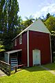
Kawana flour mill, 1854 (restored), Matahiwi
-
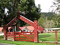
One of the many Māori marae along the Whanganui River
See also
 In Spanish: Río Whanganui para niños
