
Whanganui facts for kids
Quick facts for kids
Whanganui
|
||
|---|---|---|
 |
||
|
||
| Nickname(s):
The River City
|
||
| Motto(s):
Sans Dieu Rien,
English: Without God Nothing |
||

Whanganui
Location in New Zealand
|
||
| Country | New Zealand | |
| Region | Manawatū-Whanganui | |
| Territorial authority | Whanganui District Council | |
| Area | ||
| • Territorial | 2,373.26 km2 (916.32 sq mi) | |
| • Urban | 41.05 km2 (15.85 sq mi) | |
| Population
(June 2023)
|
||
| • Territorial | 48,900 | |
| • Density | 20.605/km2 (53.37/sq mi) | |
| • Urban | 42,800 | |
| • Urban density | 1,042.6/km2 (2,700/sq mi) | |
| Postcode(s) |
4500, 4501
|
|
| Area code(s) | 06 | |
| Website | Whanganui.govt.nz | |

Whanganui is a city located in the Manawatū-Whanganui region of New Zealand. It is also sometimes spelled Wanganui. The city sits on the west coast of the North Island, right where the Whanganui River meets the sea. This river is New Zealand's longest waterway that boats can travel on. Whanganui is the 19th largest urban area in New Zealand by population. It is also the second largest in its region. As of 2018, about 39,720 people live there.
Whanganui is the original home of the Te Āti Haunui-a-Pāpārangi and other Whanganui Māori tribes. In 1840, the New Zealand Company started to settle the area. It was their second settlement after Wellington. Many early European settlers came from Wellington. Whanganui grew a lot in the 1870s. Businesses like meat processing plants (freezing works), wool factories, and wool storage buildings were built. Today, Whanganui's economy is closely linked to the rich farmland around it. This area is called the hinterland.
Whanganui was once officially called a city. But in 1989, changes were made to how local areas were managed. Now, the Whanganui District Council runs the area.
Contents
- What's in a Name?
- Whanganui's Past
- Exploring Whanganui's Geography
- People of Whanganui
- Whanganui's Economy
- The Whanganui District
- Whanganui's Culture
- Famous Buildings and Landmarks
- Fun Places to Visit
- Sports in Whanganui
- How Whanganui Works
- Learning in Whanganui
- Whanganui in the News
- Famous People from Whanganui
- Sister Cities
- Images for kids
- See also
What's in a Name?
The name Whanga nui comes from the Māori language. It means "big bay" or "big harbour." The first European settlement here was called Petre. It was named after Lord Petre, who worked for the New Zealand Company. But people didn't really like that name. So, in 1854, it was officially changed to "Wanganui."
The Whanganui Spelling Debate
In the local Māori language, the "wh" in Whanganui is pronounced in a special way. It sounds a bit like "Wanganui" to people who are not from the area. This makes it hard for some to say correctly.
In 1991, some local Māori asked the New Zealand Geographic Board to change the river's name to Whanganui. The Wanganui District Council did not agree with this change. After thinking about it, the Board decided to change the river's name from "Wanganui" to "Whanganui."
In 2006, people in Wanganui voted on whether to keep the city's name as "Wanganui" (without the 'h'). Most people (82%) voted to keep it as "Wanganui." Even with this vote, the spelling of the name remained a topic of discussion.
On 17 November 2015, the official name of the District was changed to Whanganui District. This also changed the official name of the urban area. Then, in September 2019, the wider region was renamed from Manawatu-Wanganui to Manawatū-Whanganui.
Whanganui's Past
Early Māori Life
The area around the mouth of the Whanganui River was a very important place for Māori people before Europeans arrived. The pā (fortified village) called Pūtiki was, and still is, home to the Ngāti Tūpoho hapū (sub-tribe) of the iwi (tribe) Te Āti Haunui-a-Pāpārangi. The name Pūtiki comes from a story about the explorer Tamatea Pōkai Whenua. He sent a servant to find flax to tie up his hair (pūtiki).
In the 1820s, coastal tribes in the area attacked the Kapiti Island stronghold of Ngāti Toa chief Te Rauparaha. Te Rauparaha fought back in 1830. He attacked Pūtiki and killed many people living there.
European Settlers Arrive
The first European traders came in 1831. Then, in 1840, missionaries Octavius Hadfield and Henry Williams arrived. They collected signatures for the Treaty of Waitangi. On June 20, 1840, Revd John Mason and others came to set up a mission station. Revd Richard Taylor joined them in 1843. A new church was built under Taylor's guidance. Each Māori village along the river helped by providing timber.

After settling Wellington, the New Zealand Company looked for more places for settlers. William Wakefield bought 40,000 acres in 1840. A town called Petre was started four kilometres from the river mouth. In 1846, Te Mamaku, a chief from up the Whanganui River, threatened the settlement. The British military arrived to protect the town. They built two forts, Rutland and York. There were two small battles in 1847. After a standoff, the upriver tribes went home. By 1850, Te Mamaku was learning about Christianity from Revd Taylor.

The city's name officially changed to Wanganui on January 20, 1854. The first years of the new city were difficult. Land purchases from local tribes were not always clear. Many Māori were angry about Europeans settling on land they still claimed. It took eight years for agreements to be reached. But some bad feelings remained.

Wanganui grew quickly after this. Land was cleared for farms. The town was an important military center during the New Zealand Wars of the 1860s. However, local Māori at Pūtiki, led by Te Keepa Te Rangihiwinui, remained friendly with the settlers. In 1871, a town bridge was built. Six years later, a railway bridge was built at Aramoho. By 1886, Wanganui was connected by train to both New Plymouth and Wellington. The town became a Borough on February 1, 1872. William Hogg Watt was the first Mayor. It became a city on July 1, 1924.
Women's Political League
In 1893, Margaret Bullock started a club for women activists. It was called the Wanganui Women's Franchise League. Its goal was to help women get the right to vote. Ellen Ballance, the wife of a former Premier, was the first president. After women won the right to vote, the club changed its name to the Women's Political League. It grew to almost 3000 members. The club held monthly meetings to discuss feminist ideas. Ellen Ballance gave her husband's library to the club. Bullock and Jessie Williamson helped the club connect with the National Council of Women of New Zealand. By 1903, the club's activities slowed down. Its library collection was given to the local public library.
20th Century Changes
In 1920, a big event happened in Wanganui. Mayor Charles Mackay shot and injured a young poet, Walter D'Arcy Cresswell. Mackay went to prison for seven years. His name was removed from public monuments. Later, in 1985, his name was put back on the Sarjeant Gallery building.
The Whanganui River area is considered sacred by Māori. The Whanganui region is still a focus for discussions about land ownership. In 1995, Moutoa Gardens in Wanganui (known as Pakaitore to local Māori) was occupied for 79 days. This was a mostly peaceful protest by the Whanganui iwi about land claims.
From 1976 to 1995, Wanganui was home to the New Zealand Police's Law Enforcement System (LES). This was an early computer system used for police information. People often called it the "Wanganui Computer."
Exploring Whanganui's Geography
Whanganui is located on the South Taranaki Bight. This is a large bay near the mouth of the Whanganui River. It is about 200 kilometres north of Wellington. It is also about 75 kilometres northwest of Palmerston North. The city is at the meeting point of State Highways 3 and 4. Most of the city is on the river's northwestern side. This is because there is more flat land there. Five bridges cross the river: Cobham Bridge, City Bridge, Dublin Street Bridge, Aramoho Railway Bridge (for trains and walkers), and a Cycle bridge opened in 2020.
You can see both Mount Ruapehu and Mount Taranaki from Durie Hill. There are also other good viewing spots around the city.
City Areas and Neighborhoods
Whanganui has several suburbs and localities. These include:
- Northeast: Whanganui East, Bastia Hill, Aramoho
- East: Durie Hill
- South: Pūtiki
- West: Gonville, Castlecliff, Tawhero
- Northwest: Springvale, St Johns Hill, Otamatea
Whanganui's Climate
Whanganui has a mild climate. It gets a bit more sunshine than the national average, about 2100 hours each year. The city receives about 900 millimetres of rain annually. There are usually a few light frosts in winter. The river can flood after heavy rain. In June 2015, there was record flooding, and 100 homes had to be evacuated. Whanganui's climate is very moderate. In 2012, a local farmer said that the district's mild climate meant any type of farming could be done there.
People of Whanganui
The Whanganui urban area had a population of 39,720 people at the 2018 New Zealand census. This was an increase of 3,078 people since the 2013 census. There were 18,930 males and 20,793 females. About 19.8% of the people were aged 15 years or younger. About 21.3% were aged 65 or older.
The ethnic makeup of Whanganui was: 78.0% European/Pākehā, 27.2% Māori, 3.8% Pacific peoples, 4.5% Asian, and 1.7% other ethnicities. (These numbers add up to more than 100% because people can choose more than one ethnicity).
Whanganui's Economy
Whanganui has been recognized as one of the world's Smart21 Intelligent Communities by the Intelligent Community Forum several times (2013, 2014, 2015, 2016).
The city has a strong industrial base. It has a history of making special, unique products. For example, Q-West Boat Builders at the Port builds boats for customers worldwide. In 2015, they won a contract to build two large passenger ferries for Auckland. Pacific Helmets is another company that makes award-winning specialized products. They won a Silver Pin at the Best Design Awards in 2015 for their helmets. Heads Road is Whanganui's main industrial area. Many factories and engineering businesses are located there. The Wanganui Port was once a busy transport hub. It still has some shipping traffic, but it is now best known for Q-West boat building.
A big part of Whanganui's economy comes from the rich and successful farms nearby. Whanganui is also known for growing new types of pears, like the Crimson Gem.
The Whanganui District
The Whanganui District covers 2337 square kilometres. Most of this area is hilly. There is a narrow flat strip of land along the coast. The main city settlement is on the lower banks of the Whanganui River. A large part of the district is within the Whanganui National Park, which was created in 1986.
The region is famous for its beautiful natural environment. The Whanganui Awa (River) is at its heart. It is the second-largest river in the North Island. It is also the longest river in New Zealand that boats can travel on. The river flows for 290 kilometres from Mount Tongariro to the Tasman Sea. Every bend and rapid on the river has a guardian, or kaitiaki. They protect the mauri (life force) of that part of the river.
Whanganui hapū (sub-tribes) were known for their amazing canoeing skills. They built many weirs and fishing traps along the river. Generations of river iwi have learned to use and protect this great taonga (treasure). On September 13, 2012, the Whanganui River became the first river in the world to be recognized as a legal identity. This means it has similar rights to a person.
Today, people use the river and its surroundings for many fun activities. These include kayaking, jet boating, hiking, cycling, and camping. A national cycleway recently opened. It takes cyclists from the mountains to the sea.
In the 1980s, local government areas were reorganized. The Wanganui District Council was formed in 1989. It combined the Wanganui County Council and other smaller councils. Hamish McDouall was elected mayor in 2016.
Most people in the Whanganui District live in the main city. This means there are few large towns outside of Whanganui itself. A small but well-known village is Jerusalem. It was home to Mother Mary Joseph Aubert and the poet James K. Baxter.
The Whanganui District also has other small settlements. These include Kaitoke, Upokongaro, Kai Iwi/Mowhanau, Aberfeldy, Westmere, Pākaraka, Marybank, Okoia, and Fordell.
Whanganui's Culture

Cultural Places
Whanganui has many cultural and recreational activities. Queen's Park (Pukenamu) is in the city center. It used to be the site of the Rutland Stockade. Now, it has several important buildings. These include the Sarjeant Gallery, the Whanganui Regional Museum, the Davis Library, the Alexander Heritage and Research Library, and the Whanganui War Memorial Centre. Whanganui is also home to New Zealand's only glass school. It is famous for its glass art.
Sarjeant Gallery Art Collection
.JPG)
The Sarjeant Gallery has over 8,000 artworks. It first focused on British and European art from the 1800s and early 1900s. But thanks to the wishes of its founder, Henry Sarjeant, the collection now includes art from the 1500s to today. The collection has historical and modern works. These include drawings, sculptures, pottery, ceramics, glass, bronze works, video art, and paintings. The gallery has famous works by artists like Edward Burne-Jones, Domenico Piola, and Frank Brangwyn. It also has a major collection of works by Whanganui-born artist Edith Collier.
Whanganui Regional Museum Collection
The Whanganui Regional Museum has been collecting items for a long time. The first items were shown in Samuel Henry Drew's shop window. The collection includes artwork by John Tiffin Stewart.
Local Artists
Many potters have worked in the area for a long time. These include Rick Rudd, Paul Rayner, and Ivan Vostinar. Local glass artists include Kathryn Wightman, Lisa Walsh, and Claudia Borella.
Theatre and Opera
A repertory group has been performing in the town since 1933. Since 1994, The New Zealand Opera School has been held at Whanganui Collegiate School.
Famous Buildings and Landmarks

Pukenamu–Queens Park in central Whanganui is home to several famous buildings. The Sarjeant Gallery is a very important historical building. It was given to the town by local farmer Henry Sarjeant. It opened in 1919. Since 2014, it has been in a temporary location. This is because the old building is being made stronger and improved. The Whanganui Regional Museum (1928) and the Alexander Heritage and Research Library (1933) were also gifts from the Alexander family. The Whanganui War Memorial Hall (1960) has won awards. It is a great example of modern architecture in New Zealand.
The Royal Whanganui Opera House is on St Hill Street in central Whanganui.
Stewart House is now a private home. But it used to be a home for babies and later a boarding house for high school students. It was built for John Tiffin Stewart and Frances Ann Stewart.
Two large towers overlook Whanganui. These are the Durie Hill War Memorial Tower and the Bastia Hill Water Tower. The Durie Hill Tower is a memorial for World War I. It was opened in 1926. Near it is the Durie Hill Elevator (1919). This elevator connects the hilltop with Anzac Parade. It goes up 66 metres and through a 200-metre tunnel. South of Whanganui is the Cameron Blockhouse.

Rotokawau Virginia Lake is on St John's Hill. It is a historic lake with a fountain, an Art Deco conservatory, and a winter garden.
Fun Places to Visit
Bason Botanic Gardens
These gardens are about 8 kilometres northwest of Whanganui. They cover 25 hectares and have a climate that is mostly free of frost. Stanley and Blanche Bason started them in 1966. They gave their farm to the city to create a botanical reserve. The gardens have six different themed areas. They also have one of the largest public collections of orchids in New Zealand. The New Zealand Gardens Trust has called them a Garden of Significance.
Bushy Park Tarapuruhi
Bushy Park is a piece of lowland rainforest. It is about 100 hectares in size. It is located 8 kilometres from Kai Iwi, north of Whanganui. It is a bird sanctuary where there are no predators. You can visit the sanctuary for free during the day. The park also has an Edwardian-era homestead. This old house is a Category 1 heritage building.
Sports in Whanganui
|
|||||||
Rugby
The Wanganui Rugby Football Union is one of the oldest rugby unions in New Zealand. Wanganui has never won the country's top rugby trophy, the Ranfurly Shield. In 1966, a combined Wanganui and King Country team beat the British and Irish Lions 12 points to 6.
In 2008, the Wanganui rugby team won the NZRFU's Heartland Championship (Meads Cup). They beat Mid Canterbury 27–12 in the final. They had been finalists in 2006 and 2007. The 2008 team had a perfect season, winning every game. This was the first time since 1947. The team was given the special honour of 'Freedom of the City' by the Whanganui District Council. This was the first time a sports team received this award.
The 2009 team won the Meads Cup again. They beat Mid Canterbury 34 points to 13. Ten Whanganui players were chosen for the Heartland XV team. The Wanganui rugby jersey is sometimes called the "butcher's apron" because of its look.
Many All Blacks (New Zealand's national rugby team) have come from the Whanganui area. Some famous ones include:
- Moke Belliss (1920–23)
- Andy Haden (1972–85)
- Bill Osborne (1975–82)
- Glen Osborne (1995–99)
Even though he was from Manawatu, 1987 Rugby World Cup winning All Black Captain David Kirk studied at Whanganui Collegiate School.
Athletics
Whanganui has excellent sports venues. One is Cooks Gardens. It is a major venue for cricket, athletics, and rugby. On January 27, 1962, Peter Snell set a world record for running the mile there. He ran it in 3 minutes and 54.4 seconds on the grass track. The venue also has a world-class velodrome for cycling.
Motor-racing
The Cemetery Circuit is a temporary motorcycle race track in downtown Whanganui. It goes through an old cemetery and industrial area. This event usually happens on Boxing Day each year. Rod Coleman was a famous Grand Prix motorcycle road racer from Whanganui. Earl Bamber is a racing driver. He won the 2015 24 Hours of Le Mans and the 2014 Porsche Supercup.
Horse Racing
The Wanganui Jockey Club operates at the Wanganui Racecourse. It has been there since 1848. It is said to be the oldest racing club in New Zealand still using its original land. Important races held here include the Ag Challenge Stakes and the Wanganui Cup. New Zealand Racing Hall of Fame and Australian Racing Hall of Fame jockey Brent Thomson was born and started his career in Wanganui.
How Whanganui Works
Transport
Whanganui Airport has flights to Auckland with Air Chathams. Horizons Regional Council runs ten weekday urban bus routes in the city. There is also a Saturday route. From February 18, 2023, a frequent bus (every 20 minutes) connects Castlecliff and Aramoho. The regional council also runs buses to Palmerston North. All bus services are run by Tranzit Group. Bus cards were changed to Bee Cards in December 2019.
Whanganui used to have trams. They ran between Aramoho and Castlecliff from 1908 to 1950. Then, buses replaced them. The town also had three train stations. A passenger train ran to New Plymouth until 1977. Today, the train line is used for freight.
Energy
Whanganui was one of the first nine towns in New Zealand to get natural gas. This happened in 1970 when the Kapuni gas field started producing gas. A long pipeline was built from Kapuni to Wellington, passing through Whanganui.

Whanganui first received piped gas made from coal in March 1879. Coal was brought in by ship.
Learning in Whanganui
- Whanganui Collegiate School is in Liverpool Street. It was started in 1852. It was originally a boys-only school. In 1991, girls were allowed in the senior levels. By 1999, it became fully co-educational. The school celebrated its 150th anniversary in 2004. In 2010, it joined with St George's School. The combined schools offer primary education for day students at the St George campus. They offer secondary education for day and boarding students at the Collegiate campus. Prince Edward, Earl of Wessex, spent some time at the school in 1982 and 1983 as a junior teacher.
- Whanganui City College is in Ingestre Street. It has had three names. It started as Wanganui Technical College in 1911. It became Wanganui Boys' College in 1964. In 1994, it became Wanganui City College.
- Whanganui High School is in Purnell Street.
- Whanganui Girls' College is in Jones Street, Whanganui East. It is near the Dublin Street Bridge.
- Cullinane College is a co-educational college in Peat Street, Aramoho.
- St. Dominic's College is in York Street, Gonville.
- Te Kura Kaupapa Māori o Te Atihaunui-A-Paparangi is in Anaua Street, Putiki.
- Te Kura o Kokohuia is in Matipo Street, Castlecliff.
- Te Kura Kaupapa Māori o Tupoho is in Cross Street, Castlecliff.
- UCOL, Universal College of Learning, started in 1907. It was first known as the Palmerston North Technical School. It grew and in 2002, the Whanganui Regional Community Polytechnic became part of it.
- The Wanganui Regional Community Polytechnic is now called Whanganui UCOL. It includes the Wanganui School of Design.
Whanganui in the News
Whanganui has three local newspapers. The Wanganui Record was the first newspaper in the wider Wellington region. It was first published in 1853. The Whanganui Chronicle, started in 1856, is New Zealand's oldest newspaper. It has been a daily paper since 1871. Its main competitor was the Evening Herald (later the Wanganui Herald). The two daily papers joined in the 1970s. In 1986, the Herald became a free weekly paper, later called the Wanganui Midweek. The River City Press is another free weekly paper.
Whanganui is served by 25 radio stations. In 1996, Whanganui became famous for a short time around the world. A man claimed to have a bomb and held a local radio station (Star FM, now More FM Whanganui) hostage. He demanded that the station play The Muppets song "The Rainbow Connection" for 12 hours.
Television came to Whanganui in 1963. This happened after the Wharite Peak transmitter started working. Today, digital television (Freeview) is available in the city.
Famous People from Whanganui
- Israel Adesanya (born 1989), mixed martial artist
- Sister Mary Joseph Aubert (1835–1926), who started Our Lady of Compassion at Jerusalem
- Earl Bamber, racing car driver
- Airini Beautrais, poet
- Paul Callaghan, physicist
- Edith Collier, artist
- Johnny Devlin, musician
- Peter Gordon, international chef
- Michael Laws, former mayor
- Douglas Lilburn, composer
- Te Mamaku, Māori chief
- Robert Martin, disability rights activist
- Jerry Mateparae, former Chief of the New Zealand Defence Force and Governor General of New Zealand
- Anne Noble, photographer
- Glen Osborne, All Black rugby player
- Bill Osborne, All Black rugby player
- Victoria Ransom, software entrepreneur
- Iriaka Rātana, first Māori woman in New Zealand parliament
- Henry Sarjeant, farmer and supporter of the Sarjeant Art Gallery
- Tim Seifert, cricketer
- John Tiffin Stewart, engineer, artist and helper of others
- Brian Talboys, politician
- Richard Taylor, early missionary
- James Allen Ward, a soldier who received the Victoria Cross
- Jane Winstone, aviator
Sister Cities
Whanganui has sister city relationships with:
- Toowoomba, Queensland, Australia (since 1983)
- Nagaizumi, Shizuoka, Japan (since 1988)
In 2008, the Wanganui District Council decided to end its sister city relationship with Reno, Nevada, USA. This was because there had been no activity for many years.
Images for kids
-
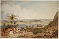
View of Whanganui, New Zealand, 1847, John Alexander Gilfillan, watercolour
-
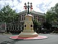
The Watt Fountain in Victoria Avenue. The former Post Office building is in the background.
-
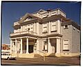
The Royal Whanganui Opera House, March 1967. The building, one of New Zealand's last Victorian theatres, still stands today.
-
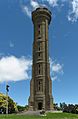
The War Memorial Tower on Durie Hill
-
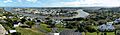
A panoramic view of Whanganui, New Zealand, from the top of the War Memorial Tower on Durie Hill. In the centre is Whanganui City Bridge.
-
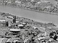
Whanganui gas works, showing a collier at the jetty, the coal conveyor, works and gas holders in 1955
See also
 In Spanish: Whanganui para niños
