Kapiti Island facts for kids

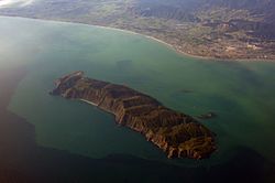
Aerial view of Kapiti Island, with Paraparaumu in the background.
|
|
| Geography | |
|---|---|
| Location | Tasman Sea |
| Coordinates | 40°52′S 174°54′E / 40.867°S 174.900°E |
| Area | 19.65 km2 (7.59 sq mi) |
| Length | 8 km (5 mi) |
| Width | 2 km (1.2 mi) |
| Highest elevation | 521 m (1,709 ft) |
| Highest point | Tuteremoana |
| Administration | |
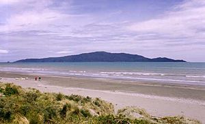
Kapiti Island is a special island located about 5 km (3 mi) off the west coast of the lower North Island of New Zealand. It is about 10 km (6 mi) long and 2 km (1.2 mi) wide, covering an area of 19.65 km² (7.59 sq mi). Since 1989, its name has been used by the Kapiti Coast District Council, which includes nearby towns like Paekakariki and Paraparaumu.
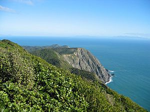
The island is separated from the North Island by a channel called Rauoterangi. The highest point on Kapiti Island is Tuteremoana, which is 521 m (1,709 ft) tall. The west side of the island is very rocky with tall cliffs that drop straight into the sea. Strong winds hit these cliffs, making the plants there grow low and stunted. The island's shape shows it lies on a fault line, like a part of the Tararua Range. Most of the island is covered in scrub and forest with trees like kohekohe, tawa, and kanuka. Much of the forest is growing back after being cleared for farming. But some parts still have tall, old trees, up to 30 m (98 ft) high.
What's in a Name?
The traditional Māori name for the island is Te Waewae-Kapiti-o-Tara-rāua-ko-Rangitāne. This name describes how the island was divided between the lands of Ngāi Tara (now Muaūpoko) and Rangitāne iwi (tribes). The word kapiti means "to be joined."
The island also became known to Māori as Motu Rongonui, meaning "the famous island." When James Cook explored New Zealand in 1770, he called it Entry Island. However, this name did not become popular.
A Look Back: Kapiti Island's History
Māori people have lived in the Kapiti Coast area since the 12th century. Around 1150, a Māori navigator named Whātonga divided the land. The area from the southern tip of Kapiti Island north went to his son Tautoki's descendants, who became the Rangitāne tribe. The land from the southern tip south went to his son Tara's descendants, Ngāi Tara. The island's traditional name shows this old division.
In the early 1800s, the island belonged to the Muaūpoko tribe. Te Rauparaha of the Ngāti Toa tribe saw how useful Kapiti Island was. Western ships often visited the Cook Strait area. In 1822, Te Rauparaha led Ngāti Toa to settle on Kapiti Island and Waikanae. They took control of the island from Muaūpoko in 1823. The tribe used canoes to travel and raid areas from the Whanganui River to Marlborough. In 1824, in the Battle of Waiorua, Ngāti Toa defeated a large force of 2,000 warriors who tried to capture the island.
Te Rauparaha encouraged European ships to visit Kapiti. By 1830, the island became a busy place for the New Zealand flax trade. In the 1830s and 1840s, it became a major center for whaling. This was because the South Taranaki Bight and Cook Strait were important areas where whales had their babies. During whaling times, about 2,000 people lived on the island. Whale oil was melted from blubber and sent to America to be used in machines. Five whaling stations were set up on Kapiti, with three more on smaller nearby islands. At this time, the island was covered in forests of rātā, kahikatea, and rimu trees.
After the whaling industry ended in the 1840s, the whalers and their families left. By 1850, no Ngāti Toa lived on the island permanently, though they visited for its resources. During this time, the land was rented to European farmers and much of the forest was cut down. In the late 1800s, the government started thinking about making Kapiti Island a wildlife reserve. This was because many native plants and animals were being lost across New Zealand.
By the 1900s, the New Zealand government had bought most of the island for the reserve. However, a part in the north remained with Ngāti Toa. This land was farmed by the Webber family until the 1950s. Most of this land was sold in 1967, but Ngāti Toa still own some land and have rights to visit the island.
In 1987, the Department of Conservation (DOC) took over managing the island. In the 1980s and 1990s, big efforts were made to return the island to its natural state. First, sheep and possums were removed. Then, in 1998, rats were removed, which was a huge task for an island of its size. This made the island a safe home for native wildlife again.
Kapiti Island Today

Today, Kapiti Island is a special place called the Kapiti Island Nature Reserve. It is next to the Kapiti Marine Reserve. Most of the island is owned by the New Zealand Crown.
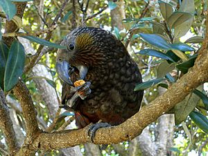
The island is home to many native birds, most of which have been brought back to the island. These include takahe, North Island kōkako, brown teal, stitchbird (hihi), North Island saddleback (tieke), tomtit (miromiro), fantail (piwakawaka), morepork (ruru), weka, and North Island robin (toutouwai). The brown kiwi and little spotted kiwi were released there between 1890 and 1910. The island is now the main home for the little spotted kiwi.
Getting rid of rats has helped many birds, like red-fronted parakeets, North Island robins, bellbirds, and saddlebacks. Kapiti Island is considered one of New Zealand's most important places for helping birds recover. It is also a major breeding site for seabirds. In 2005, the very rare short-tailed bat was brought to the island. This gave them a safer place to live away from dangers.
Because it is close to Wellington, many tourists visit the island. Only 160 people are allowed each day. It is a very popular place for birdwatchers. New Zealand birds are not afraid of people because they have no natural mammal predators. Visitors can often see many different bird species up close.
In 2007, a building at the Department of Conservation ranger station caught fire. Many firefighters were flown to the island to stop the fire from spreading to the native bush. They managed to control the blaze, preventing serious damage to the island's ecosystem.
In 2010, a stoat was seen on the island. Stoats are introduced animals that harm New Zealand's bird life. By August 2011, the Department of Conservation had caught three stoats. It is thought they could not have swum the 5 km (3 mi) from the Kapiti Coast.
Kapiti Island is an important coastal area for native birds in the Wellington region. It provides a safe place for little blue penguins, red-billed gulls, white-fronted terns, and reef herons to nest without predators. Four other threatened or at-risk bird species also live along the coast of Kapiti Island. These include the black shag, the Caspian tern, the pied shag, and the variable oystercatcher.
See also
 In Spanish: Isla Kapiti para niños
 | Laphonza Butler |
 | Daisy Bates |
 | Elizabeth Piper Ensley |


