
Manawatū-Whanganui facts for kids
Quick facts for kids
Manawatū-Whanganui
|
|
|---|---|
|
Region
|
|
 |
|
| Country | New Zealand |
| Island | North Island |
| Established | 1989 |
| Seat | Palmerston North |
| Territorial authorities | |
| Area | |
| • Land | 22,220.67 km2 (8,579.45 sq mi) |
| Highest elevation | 2,797 m (9,177 ft) |
| Lowest elevation | 0 m (0 ft) |
| Population
(June 2023)
|
|
| • Region | 260,900 |
| Time zone | UTC+12:00 (NZST) |
| • Summer (DST) | UTC+13:00 (NZDT) |
| ISO 3166 code | NZ-MWT |
| HDI (2017) | 0.894 very high · 13th |
| Website | Horizons.govt.nz |
Manawatū-Whanganui is a large region located in the lower part of the North Island of New Zealand. Its main cities are Palmerston North and Whanganui. The region is managed by the Manawatū-Whanganui Regional Council, also known as Horizons Regional Council. Before 2019, the region was spelled Manawatu-Wanganui.
Contents
What's in a Name?
The name Manawatū comes from an old Māori song (waiata). This song tells the story of an ancestor named Haunui-a-Nanaia. He was looking for his wife and named many rivers in the area. The song says his heart (manawa) rested (tatū) when he saw the Manawatū River.
The name Whanganui means "big bay" or "big harbour". The first European settlement in the area was called Petre, but this name was not popular. It was officially changed to "Wanganui" in 1854.
In 2019, the New Zealand Geographic Board decided to change the official spelling of the region to "Manawatū-Whanganui". This change added the letter "h" and a macron (a line above a vowel) to Whanganui. This new spelling became official on October 18, 2019.
Exploring the Geography
This region is shaped by two important rivers: the Whanganui and the Manawatū.
Whanganui River's Importance
The Whanganui River, in the northwest, is New Zealand's longest river that boats can travel on. It was very important to early Māori because it connected waterways across much of the North Island. Many Māori settlements were built along its cliffs, which were easy to defend and had plenty of food. The river is still considered sacred by the local Māori tribes (iwi).
Manawatū River and Plains
The Manawatū River flows through the middle of the region. It starts in the eastern hills and flows to the fertile Manawatū Plains in the west. Palmerston North, the region's main city, is on these plains. This city is a key service hub for the southern North Island.
The Manawatū River is special because it flows through a deep gorge, called the Manawatū Gorge, even though the land around it is much higher. This shows that the hills have risen since the river first formed.
Diverse Landscapes
Manawatū-Whanganui is the second-largest region in the North Island, covering over 22,000 square kilometers. It stretches from north of Taumarunui to south of Levin on the west coast, and across to the east coast. It shares borders with the Waikato, Taranaki, Hawke's Bay, and Wellington regions.
The region has many different types of landscapes:
- Areas near the Volcanic Plateau are high and rugged, with cold winters.
- The Manawatū District has flatter land, mostly the Manawatū Plains, which are between the mountains and the sea.
- The Whanganui District is more rugged, with deep valleys and gorges carved by rivers and ocean waves.
Towering Mountains and Rivers
The region includes several mountain ranges, like the Tararua Range and the Ruahine Range. It also has the North Island's three main active volcanoes:
- Mount Ruapehu (2,797 m) – the tallest mountain in the North Island. It last erupted in 1995 and 1996.
- Ngauruhoe (2,291 m)
- Tongariro (1,968 m)
Three major rivers flow through the region:
- The Whanganui River (290 km)
- The Manawatū River (182 km)
- The Rangitīkei River (241 km)
The Whanganui River is the second-longest river in the North Island. It drains much of the inland area west of Lake Taupō. This area has few roads and still has some of the largest native forests in the North Island.
Climate and Environment
Soil and Weather
The soils in Manawatū-Whanganui are very good for farming, especially when farmers add fertilizer.
- Near the coast in Manawatū and Horowhenua, there are sandy soils and wet areas.
- Further inland, there are fertile river flats and swampy areas.
- The hill country is good for sheep and beef farming.
The region has a mild climate, but inland areas can have more extreme weather.
- The lowest temperature ever recorded in the North Island was -13.6°C at Chateau Tongariro in 1937.
- Summers are warm, with average daily temperatures between 20.1 and 22.9°C.
- Winters are colder inland, with places like Waiouru having an average low of 0.1°C.
- Rainfall is about average for New Zealand, between 1,000-2,000 mm per year.
Parks and Conservation
About one-seventh of the region's land is protected for conservation.
- Tongariro National Park is the largest park in the region (795.98 km²) and New Zealand's oldest national park, created in 1887. The volcanoes Tongariro, Ruapehu, and Ngauruhoe are sacred to Māori and are part of a World Heritage Site.
- Whanganui National Park (742.31 km²) was created later, in 1986.
- There are also two state forest parks in the Ruahine Range and Tararua Range.
These parks offer activities like skiing, tramping, jetboating, and white-water rafting.
The regional council works to protect the environment. They manage flood protection and deal with problems like pest infestation and pollution. They have programs to control invasive plants like African feathergrass and animal pests like possums, rabbits, and feral goats.
Amazing Wildlife
The Ramsar wetlands at Foxton Beach are a special place for birds. It has one of the most diverse ranges of wetland birds in New Zealand, with 95 different species identified. It's an important feeding ground for many birds, including the Eastern bar-tailed Godwit, which flies all the way from Siberia! This estuary is also home to 13 species of birds, six species of fish, and four plant species that are all threatened.
People and Culture
Manawatū-Whanganui Region covers about 22,220 square kilometers. As of 2018, it had an estimated population of about 238,797 people.

Cities and Towns
The two main urban areas are:
- Palmerston North: This city has grown as an educational center and a place that provides services to the surrounding farms. It became a city in 1930.
- Whanganui: This is the other major urban area.
Here are some of the larger towns in the region:
| Urban area | Population (June 2023) |
% of region |
|---|---|---|
| Palmerston North | 82,500 | Expression error: Unrecognized punctuation character "[".% |
| Whanganui | 42,800 | 16.4% |
| Levin | 19,800 | 7.6% |
| Feilding | 17,750 | 6.8% |
| Dannevirke | 5,640 | 2.2% |
| Marton | 5,590 | 2.1% |
| Taumarunui | 4,800 | 1.8% |
| Foxton | 3,380 | 1.3% |
| Ashhurst | 3,350 | 1.3% |
| Pahiatua | 2,840 | 1.1% |
| Bulls | 2,210 | 0.8% |
| Foxton Beach | 2,170 | 0.8% |
| Taihape | 1,800 | 0.7% |
| Woodville | 1,670 | 0.6% |
| Shannon | 1,610 | 0.6% |
| Ohakune | 1,510 | 0.6% |
| Raetihi | 1,090 | 0.4% |
Who Lives Here?
| Largest groups of overseas-born residents | |
|---|---|
| Nationality | Population (2018) |
| England | 8,163 |
| Australia | 3,423 |
| India | 2,292 |
| China | 2,031 |
| South Africa | 1,830 |
| Philippines | 1,560 |
| Samoa | 1,290 |
| Fiji | 1,092 |
| Scotland | 1,062 |
| United States | 942 |
In the 2018 census, the people living in Manawatū-Whanganui identified their backgrounds as:
- 79.4% European/Pākehā
- 22.9% Māori
- 4.2% Pacific peoples
- 6.4% Asian
- 2.2% other ethnicities
(Note: These numbers add up to more than 100% because people could choose more than one ethnicity.)
About 14.8% of the people in the region were born overseas.
A Look Back in History
- Before 1769: About 3% of Māori lived in the Whanganui area.
- 1831: European traders arrived in the Whanganui area.
- 1840: Jerningham Wakefield bought a large area of land for the New Zealand Company, including the future site of Whanganui. The first European settlers started arriving.
- 1847: A battle called the "Battle of St John's Wood" happened between Māori and British soldiers.
- 1855: Settlers moved closer to the coast, creating the port town of Foxton.
- 1860s: People from Scandinavia settled in the Tararua District, founding towns like Eketahuna, Dannevirke, and Norsewood.
- 1866: Palmerston North was founded. It was surrounded by forests, and the Manawatū River was its only link to the outside world.
- 1870s: Forests were cleared, and the Manawatū area was opened up for European farms.
- 1877: Palmerston North became a borough (a type of town).
- 1886: A new railway line connected Wellington to Palmerston North, helping Palmerston North grow.
- 1908: The North Island Main Trunk railway reached Taumarunui, opening up inland areas for development.
- 1924: Whanganui became a city.
- 1930: Palmerston North became a city.
- 1953: New Zealand's worst rail disaster happened at Tangiwai. A train crashed after a bridge collapsed due to a lahar (a mudflow from a volcano) from Mount Ruapehu. 151 people died.
- 1963: Massey University was formed in Palmerston North.
- 1991: The government officially renamed the Wanganui River to the Whanganui River.
- 1995-96: Small eruptions occurred on Mount Ruapehu.
- 2004: Heavy rain caused the worst flooding in the region in over 100 years.
- 2015: The Whanganui district was officially renamed Whanganui by the NZ Geographic Board.
How the Region Makes Money
The economy of Manawatū-Whanganui is mostly based on agriculture. In 2019, the region's total economic output was about NZ$11.60 billion.
Farming and Food
Agriculture is very important here. The government even opened an agricultural college, Massey Agricultural College, in the 1920s to promote scientific farming. This college helped develop new breeds of sheep, like the Drysdale and the Perendale.
- About 72.5% of the land in the region is used for farming.
- Manawatū-Whanganui has the most sheep in the North Island and the fourth-highest number in New Zealand.
- Farmers also grow Barley, which is used for animal feed and making malt. The region produces the most barley in the North Island.
- The region has a lot of land for growing vegetables. It produces a significant amount of New Zealand's asparagus, lettuce, broccoli, cabbage, cauliflower, carrots, and potatoes.
Forests and Timber
Forestry has a long history in the Manawatū. Palmerston North started as a town for cutting timber. In the past, too much native forest was cut down or burned. Now, most forestry uses planted trees. Some native forests are managed for sustainable logging.
Energy Production
Manawatū-Whanganui is home to some of the largest wind farms in the Southern Hemisphere, with many turbines that generate electricity.
Tourism and Fun
The region is a popular place for visitors. It accounts for a good portion of New Zealand's guest nights. Places like Tongariro National Park attract many tourists, especially during the ski season.
Museums to Visit
Some important cultural places in the region include:
- Te Manawa in Palmerston North
- The Whanganui Regional Museum
- The multi-cultural Te Awahou Nieuwe Stroom in Foxton
Getting Around: Transport
The main highway, State Highway 1, and the North Island Main Trunk railway both run through the region, connecting Auckland and Wellington. Other highways and railway lines link the region to Hawke's Bay and Taranaki. These transport links make it easy for businesses to send their products to ports.
The region has about 8,732 km of roads.
Images for kids
-
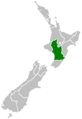
Location of Manawatū-Whanganui in New Zealand
See also
 In Spanish: Región de Manawatu-Wanganui para niños
