
Rangitīkei River facts for kids
Quick facts for kids Rangitīkei River |
|
|---|---|

Rangitīkei River near Mangaweka
|
|

The Rangitīkei River system
|
|
| Native name | Rangitīkei |
| Country | New Zealand |
| Region | Manawatū-Whanganui |
| Physical characteristics | |
| Main source | Ngapuketurua Kaimanawa Ranges 1,480 metres (4,860 ft) 39°4′52″S 176°1′52″E / 39.08111°S 176.03111°E |
| River mouth | Tasman Sea Tangimoana Sea level 40°18′2″S 175°13′31″E / 40.30056°S 175.22528°E |
| Length | 253 kilometres (157 mi) |
| Basin features | |
| Basin size | 3,948 square kilometres (1,524 sq mi) |
| Tributaries |
|
The Rangitīkei River is one of New Zealand's longest rivers. It stretches for about 253 kilometers (157 miles). This amazing river flows through the North Island, offering many exciting activities and beautiful sights. The river gives its name to the surrounding Rangitikei District.
Contents
Discover the Rangitīkei River
Where the River Begins and Ends
The Rangitīkei River starts high up in the Kaimanawa Ranges. This area is southeast of Lake Taupō. From there, it flows south across the Central Plateau. The river passes several towns like Taihape, Mangaweka, Hunterville, Marton, and Bulls. Finally, it reaches the Tasman Sea at Tangimoana, which is about 40 kilometers (25 miles) southeast of Whanganui.
River Challenges: Floods and Bridges
The Rangitīkei River has experienced many floods over the years. In 1897, a big flood damaged or destroyed all the bridges crossing it. These included bridges at Vinegar Hill, Onepuhi, Kakariki, and Bulls. The Port of Rangitikei, located at the river's mouth, was also washed away and never rebuilt. Other major floods happened in 1882, 1917, 1936, 1958, 1965, and 2004. For a long time, a ferry helped people cross the river between Tangimoana and Scotts Ferry, until 1908.
Fun on the River
The Rangitīkei River is a very popular spot for outdoor adventures! People love to go jetboating, white water rafting, and kayaking here. It's also a great place for fishing. There are public campgrounds along the riverbanks, like at Vinegar Hill, New Zealand, where you can stay.
The river is famous for its unique "paapa" (clay) cliffs. These are very steep and tall, forming deep canyons. These cliffs are perfect for thrilling activities like bungy jumping and flying fox rides! These amazing cliffs were formed over millions of years as the land slowly rose after the last ice age.
The River in Movies
Did you know that part of the Rangitīkei River was used in a famous movie? It was featured as the Anduin River in Peter Jackson's movie The Lord of the Rings: The Fellowship of the Ring. How cool is that!
River Life: Fish!
The Rangitīkei River is home to two types of trout: rainbow trout and brown trout. You can find them throughout the entire river system. In the upper parts of the river, the fish can grow very large, sometimes weighing over 4.5 kilograms (10 pounds)! In other parts of the river, the average fish size is about 1.5 to 2 kilograms (3 to 4 pounds). While there might be fewer fish in the upper sections, the ones you do find there are often bigger and stronger.
Images for kids
-
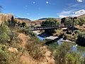
Bridge from the south
-
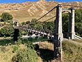
View from the east of the bridge
-
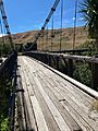
The wooden deck, view from west to east
-
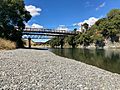
Suspension Bridge in the foreground, modern bridge behind


See also
 In Spanish: Río Rangitikei para niños
