
Rangitaiki River facts for kids
Quick facts for kids Rangitaiki River |
|
|---|---|

Rangitaiki River
|
|

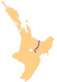
The Rangitaiki River system
|
|
| Native name | Rangitaiki |
| Country | New Zealand |
| Region | Bay of Plenty |
| District | Taupo, Whakatāne |
| Towns | Murupara, Edgecumbe |
| Physical characteristics | |
| Main source | 39°0′7″S 176°26′53″E / 39.00194°S 176.44806°E |
| River mouth | Bay of Plenty Sea level 37°54′32″S 176°52′55″E / 37.90889°S 176.88194°E |
| Length | 155 kilometres (96 mi) |
| Basin features | |
| Basin size | 3,005 square kilometres (1,160 sq mi) |
| Tributaries |
|
| Waterbodies | Lake Āniwaniwa, Lake Matahina |
| Waterfalls | Āniwaniwa Falls |
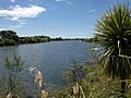
The Rangitaiki River is the longest river in the Bay of Plenty region of New Zealand. It flows through the North Island. The river is about 155 kilometers (96 miles) long. It starts in the northern part of Hawke's Bay. This area is east of the Kaingaroa Forest.
The river's basin, or the area of land that drains into it, covers 3005 square kilometers (1160 square miles). The Rangitaiki River generally flows towards the northeast. It passes by the town of Murupara. It also flows near the western edge of Te Urewera National Park. After this, it turns north. The river then flows past Edgecumbe and finally reaches the Bay of Plenty. Its mouth is close to the town of Thornton.
Contents
Man-Made Lakes and Power
There are two lakes on the Rangitaiki River that were created by people. These lakes were formed by building dams. The dams help to create electricity.
Lake Āniwaniwa

One of these lakes is Lake Āniwaniwa. It used to be called Lake Aniwhenua. This lake is important for generating hydro-electric power. Hydro-electric power uses the force of moving water to make electricity.
Lake Matahina

The other lake is Lake Matahina. Like Lake Āniwaniwa, Lake Matahina was also created by a dam. This dam helps to control the river's flow. It also helps to produce more electricity for the region.
River Activities
The Rangitaiki River is used for different activities. People enjoy the river for fishing and boating.
Fishing

The river is a popular spot for fishing. Many different types of fish live in its waters. This makes it a great place for anglers.
Boating

People also enjoy jet boating on the Rangitaiki River. Jet boating is a fun way to explore the river. It allows people to travel quickly along the water.
Images for kids
-
Rangitaiki River
-
The Rangitaiki River system
