
Taupō District facts for kids
Quick facts for kids
Taupō District
|
|
|---|---|
|
District
|
|

Eastern Lake Taupō, Tūrangi to Taupō
|
|

Location of Taupō District within New Zealand
|
|
| Country | New Zealand |
| Regions |
|
| Wards | Mangakino-Pouakani Ward Taupō Ward Turangi-Tongariro Ward Taupō East Rural Ward |
| Main towns and settlements | Taupō, Kinloch, Tūrangi, Mangakino |
| Area | |
| • Land | 6,333.05 km2 (2,445.20 sq mi) |
| Population
(June 2023)
|
|
| • Total | 42,000 |
| Time zone | UTC+12 (NZST) |
| • Summer (DST) | UTC+13 (NZDT) |
| Postcode(s) |
Map of postcodes
|
| Area code(s) | 07 |
The Taupō District is a special area in New Zealand. It's like a big local government region. This district covers a huge area of land, about 6,333 square kilometers. It also includes 610 square kilometers of lakes!
The most famous lake here is Lake Taupō, which is New Zealand's largest lake. You can also find Lake Rotoaira in the district. The Taupō District stretches from the small town of Mangakino in the northwest all the way to the Tongariro National Park in the south. It also goes east into the Kaingaroa Forest. Most people in the district live in the two main towns: Taupō and Tūrangi.
Contents
History of Taupō District
Early Māori Settlement
We don't know much about the very first Māori people who lived near Taupō. However, the Ngāti Tūwharetoa iwi (tribe) has been the main group in this area for hundreds of years. Important Māori villages, called pā, were located at the southern end of Lake Taupō. These were to the west of where the town of Tūrangi is today.
How Taupō Town Grew
The town of Taupō started in 1869. It was set up as a military base during the New Zealand Wars. For a long time, the town stayed quite small. This was because the soil in the area was volcanic and not very good for farming.
Things started to change in the 1950s. The region began to grow with new industries. Forestry became important, meaning people started planting and harvesting trees. Also, the Wairakei geothermal power station was built. This power station uses heat from the Earth to make electricity, which helped the area develop a lot.
People of Taupō District
Population Overview
The Taupō District covers about 6,333 square kilometers. As of 2018, it had an estimated population of about 37,203 people. This means there were about 5.9 people living in each square kilometer.
In the main urban area of Taupō, there were about 24,700 people. The Tūrangi urban area had about 3,100 people. The rest of the population lived in smaller towns or rural areas.
Recent Population Changes
The population of Taupō District has been growing. In the 2023 New Zealand census, there were 40,296 people. This was an increase of 3,093 people since the 2018 census. It was also a big jump of 7,389 people since the 2013 census.
The average age in the district was 42.3 years old in 2023. This is a bit older than the national average of 38.1 years.
Age Groups in the District
Here's a look at the different age groups in Taupō District in 2023:
- About 7,548 people (18.7%) were under 15 years old.
- About 6,393 people (15.9%) were between 15 and 29 years old.
- About 18,045 people (44.8%) were between 30 and 64 years old.
- About 8,310 people (20.6%) were 65 years or older.
Ethnic Backgrounds
People in Taupō District come from many different backgrounds. In 2023, the ethnic groups included:
- 74.9% European/Pākehā
- 30.9% Māori
- 3.7% Pasifika
- 6.5% Asian
- 0.8% Middle Eastern, Latin American, and African New Zealanders
- 1.3% other ethnic groups
It's important to remember that people can identify with more than one ethnicity.
Where People Were Born
About 16.6% of the people in Taupō District were born overseas. This is less than the national average for New Zealand, which is 27.1%.
Religious Beliefs
When asked about their religious beliefs in the census:
- 51.9% said they had no religion.
- 32.9% identified as Christian.
- 5.0% had Māori religious beliefs.
- Smaller numbers identified with other religions like Hindu, Muslim, and Buddhist.
Image gallery
-
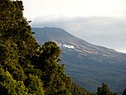
Ketetahi Springs
-
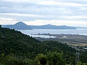
Western Taupō steam and hot springs
-
Western Taupō looking north


