
Waikato facts for kids
Quick facts for kids
Waikato
Waikato
|
|
|---|---|

Waikato within the North Island, New Zealand
|
|
| Country | New Zealand |
| Seat | Hamilton City |
| Government | |
| • Type | Regional council |
| • Body | Waikato Regional Council |
| Area | |
| • Land | 23,901.09 km2 (9,228.26 sq mi) |
| Population
(June 2023)
|
|
| • Total | 522,600 |
| GDP | |
| • Total | NZ$ 32.558 billion (2021) |
| • Per capita | NZ$ 63,713 (2021) |
| HDI (2021) | 0.923 very high · 8th |

Waikato is a large region located in the upper part of the North Island of New Zealand. It includes important cities and areas like Hamilton City, the Coromandel Peninsula, and parts of the King Country. The region is managed by the Waikato Regional Council.
Waikato stretches from the Coromandel Peninsula in the north to the slopes of Mount Ruapehu in the south. It goes from the west coast across the North Island to the east coast. The region mainly follows the path of the Waikato River. Other major rivers here are the Waihou and Piako.
Waikato is bordered by the Auckland region to the north and the Bay of Plenty to the east. To the south-east, it meets Hawke's Bay. On its southern side, it borders Manawatū-Whanganui and Taranaki. Waikato is the fourth largest region in New Zealand. It covers about 23,901 square kilometers and has a population of over 498,000 people.
The region includes all or parts of eleven different local government areas. This is more than any other region in New Zealand. The main part of Waikato includes Waikato District, Matamata-Piako District, Waipa District, South Waikato District, and Hamilton City.
Contents
What Does Waikato Mean?
The name Waikato comes from the Waikato River. In the Māori language, waikato means "flowing water." The word wai means "water," and kato means "the pull of the river current in the sea."
Sometimes people say "the Waikato" and sometimes just "Waikato." When people say "the Waikato," they usually mean a smaller area than the official government region.
Exploring Waikato's Geography

To the west, the Waikato region meets the Tasman Sea. The coastal area has rough hills, known as the Hakarimata Range. Further north, near the Waikato River's mouth, the land is flatter. Along the coast, there are three large natural harbors: Raglan Harbour, Aotea Harbour, and Kawhia Harbour. The area around Raglan is famous for its black sand beaches. It is also well-known for great surfing at Manu Bay and Ruapuke beach.
East of the coastal hills, you'll find the wide, flat land of the Waikato River. This area has a wet, mild climate. Much of the land is used for farming, especially for dairy cows. European settlers created this farmland by draining large natural swamps. Some undrained swamps, like the peat dome south of Ngatea, still exist. Most of the region's people live in these flat Waikato Plains. Farmers grow crops like maize and raise livestock. The area near Cambridge is home to many thoroughbred horse stables.
In the northern part of the region, around Te Kauwhata, some of New Zealand's best wines are produced. This area also has many small, shallow lakes. The biggest of these is Lake Waikare.
Further east, the land rises into the forested Kaimai and Mamaku Ranges. The upper parts of the Waikato River are used to make hydroelectricity. Several large artificial lakes in the south-east help with this. The oldest of these lakes is Lake Karapiro. It is now a famous place for rowing, where world championships have been held. The Waikato River flows out of New Zealand's largest lake, Lake Taupō. Several important fishing rivers, like the Tongariro, flow into Lake Taupō from the Central Plateau.
Waikato's Climate
The climate in Waikato is mild and temperate. It gets a moderate amount of rain, usually between 1200 and 1600 millimeters each year. The western hills get the most rain. Summers are drier, with temperatures usually between 22 and 28 degrees Celsius during the day. Nights are cooler, between 12 and 16 degrees. Sometimes, summer droughts happen about once every ten years.
In winter, daytime temperatures are usually between 10 and 16 degrees Celsius. Nights are colder, often between 0 and 8 degrees. Low-lying areas often have morning fog, which usually clears by late morning. This leads to many calm, clear, and sunny days. Morning frosts are also common in winter. The Waikato region has very high sunshine hours compared to many places in the world. This helps grass, crops, and plants grow quickly.
Who Lives in Waikato?
Waikato Region covers about 23,901 square kilometers. In 2023, it had an estimated population of 498,771 people. This means there are about 20 people per square kilometer.
The population has grown a lot over the years. In 2023, the population was 498,771. This was an increase of about 40,569 people since 2018. The average age in Waikato is 37.9 years. About 20% of the people are under 15 years old.
| Ethnicity | Population |
|---|---|
| New Zealand European |
357,624
|
| Māori |
125,574
|
| Pasifika |
26,139
|
| Asian |
60,792
|
| MELAA |
7,146
|
| Other |
5,742
|
People in Waikato come from many different backgrounds. In 2023, about 71.7% of people were European/Pākehā. About 25.2% were Māori. There were also people of Pasifika (5.2%), Asian (12.2%), and other backgrounds. People can identify with more than one ethnicity.
About 19.5% of the people in Waikato were born overseas. This is a bit lower than the national average for New Zealand.
Cities and Towns in Waikato

The biggest city in the Waikato Region is Hamilton. It has a population of over 192,000 people. Hamilton is home to the University of Waikato and the Waikato Institute of Technology (Wintec).
Other important towns in the region include Tokoroa, Te Awamutu, Cambridge, and Taupō. The region also has smaller towns like Huntly, Matamata, Morrinsville, Ngāruawāhia, Raglan, and Thames.
Waikato's Economy
The economy of the Waikato region is very strong. In 2019, its total economic output was estimated at NZ$25.84 billion. This was about 8.5% of New Zealand's total economy. The average income per person was about $54,128.
Between 2004 and 2007, the Waikato economy grew faster than the rest of New Zealand. This was because of the fast growth in dairy farming and business services. Being close to Auckland, New Zealand's main international city, also helped.
Agriculture and Dairy Farming
Because of its good land and climate, Waikato's economy relies heavily on agriculture, especially dairy farming. Dairy farming has been the main type of farming here since the late 1800s. In the past, there were many small dairy companies. But by the end of the 20th century, these companies merged. This led to the creation of Fonterra in 2001, a large dairy company that operates across New Zealand.
In 2007, dairy farming and processing contributed $2 billion to the region's economy. By 2014, this had grown to $2.4 billion. Most dairy farms are owned by families. Many owners hire sharemilkers to help run the farms. The average dairy herd in Waikato has grown over time. In 2016, a typical farm had about 351 cows. These cows are milked in special sheds, often using automated systems.
Cows in Waikato stay on grassy pastures all year because of the mild climate. Farmers use extra feed in winter or during dry summers. This feed includes hay, grass silage, and chopped corn.
Manufacturing in Waikato
The manufacturing sector in Waikato is also important. In 2018, it contributed $2.688 billion to the region's economy. This was about 11.1% of the total. In 2013, about 18,519 people worked in manufacturing.
Since dairy farming is so big, Waikato also has a large dairy processing industry. Fonterra has plants in places like Te Rapa, Te Awamutu, and Waitoa. Other dairy companies also have plants here.
The Waikato region has eight major meat processing plants, also called freezing works. These include AFFCO at Horotiu and Silver Fern Farms at Te Aroha. The Kinleith Mill, south of Tokoroa, turns wood from nearby forests into pulp and paper.
Waikato's Rich History

Before Europeans arrived, Waikato was one of the most populated parts of New Zealand. The Waikato area was home to iwi (tribes) like the Tainui confederation. This included the Waikato and Ngāti Toa tribes. They conquered the earlier inhabitants around 1450.
Between about 1750 and 1842, the area saw many invasions by other Māori tribes. Large groups of people moved around. The biggest battle ever fought in New Zealand happened near Ohaupo around 1790–1805. During the Musket Wars (1807–1845), conflicts led to some people moving south to Taranaki.
In 1840, 44 Waikato chiefs traveled to the Manukau Heads to sign the Treaty of Waitangi. This made the Waikato area officially part of New Zealand. Between 1840 and 1860, missionaries helped Waikato Māori improve their economy. They introduced new crops like peaches, maize, and wheat.
Missionaries also helped Māori build eight flour mills. These mills did very well until 1857. They supplied flour to Auckland and even exported some to Australia for a short time.
The main way to travel to Auckland was by dray (a type of cart) to the Puniu stream. Then, people would travel along the Waipā River to where it met the Waikato River. From there, they would enter the small Awaroa River. In summer, people sometimes had to push their waka (canoes) through to the Manukau Harbour. By the 1850s, a small track was made to Auckland. The Ngāti Maniapoto tribe used this route a lot for trading. They sold wheat, peaches, and potatoes to Auckland. In return, they bought clothes, sugar, and tobacco.
This busy trading time ended around 1856–1857. Cheaper food, especially flour, started coming from Australia. Missionaries also set up schools for Māori children. For example, Benjamin and Harriet Ashwell ran a school for 50 Māori girls in 1853. The girls learned to read and write in English.
At the time of the Waikato campaign in 1863, the government estimated there were about 3,500 Māori people in the region.
In the late 1850s, some Māori, especially the Maniapoto tribe, became unhappy with how they were treated by Europeans. They felt that the government was paying them too little for their land. The government paid about 6 pence per acre but sold it to settlers for 10 shillings per acre. This seemed unfair to Māori.
The land wars of the 1860s were a very important time in Waikato's history. The Waikato was where five major battles took place during the Invasion of the Waikato. The colonial government, with help from British troops, fought against the Māori King Movement forces. This was partly because Waikato Māori had helped Taranaki Māori in a land conflict. Also, some Waikato tribes formed a separate kingdom, the Kingitanga, which opposed the government.
The British troops moved south from Auckland. They fought against Waikato forces in many places like Meremere, Rangiriri, and Ōrākau. The Kingitanga forces were defeated in 19 battles. They eventually moved to an area south of the Punui River, which is still known as the King Country. The movie Rewi's Last Stand (1925) tells a fictional story about the Ōrākau siege.
Today, the main center for the Māori King Movement is at Turangawaewae Marae in Ngāruawāhia.
After the war, the region faced a long period of economic difficulty. Most Māori had moved to the King Country. European settlers were more interested in the South Island because of its gold and easier farming land. Waikato had poor access to transport and was not good for sheep farming. However, the growth of dairy farming and the completion of the main railway line around 1900 helped the population slowly increase. After 1900, dairy production continued to grow, with butter and cheese mainly exported to Britain.
People of Waikato
People from the Waikato region are sometimes called "Mooloo." This nickname is often used for sports teams, especially the Waikato provincial rugby team. It comes from a mascot: a cow used in parades and sports matches. This mascot shows how important the dairy industry is to the region.
Waikato is home to the Chiefs Super Rugby team and the Waikato Mitre 10 Cup rugby team. Both play at Waikato Stadium in Hamilton. The Northern Districts Knights cricket team plays at Seddon Park, also in Hamilton.
Famous People from Waikato
Arts
- The Datsuns — a rock band
- Tim and Neil Finn — famous songwriters and musicians (from bands like Split Enz and Crowded House)
- Kimbra — a well-known New Zealand singer-songwriter
- Dame Malvina Major — an internationally recognized singer
- Frank Sargeson — a celebrated New Zealand writer
Māori Leaders
- Te Puea Herangi — a significant Māori princess and leader
- Tūheitia Paki — the current Māori King (since 2006)
- Eva Rickard — a leader who defended Māori land rights
- Te Atairangikaahu — the Māori Queen (1966-2006)
- Te Rauparaha — a famous Māori chieftain and warrior
Sports Stars
- Don Clarke — a rugby international player
- Bruce McLaren — a motor racing driver and founder of a racing team
- Colin Meads — a rugby international player
- Peter Snell — a gold medal-winning distance runner at the Olympics
- Mark Todd — an Olympic equestrian rider, called "Horseman of the Century"
- Daniel Vettori — a former captain of the New Zealand cricket team
Images for kids
-
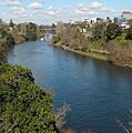
Waikato River passing through Hamilton
-
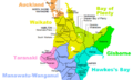
Territorial authorities in Waikato region before 2010
-

Māori woman with a representation of the Waikato Ancestress "Te Iringa"
See Also
 In Spanish: Región de Waikato para niños
