
Morrinsville facts for kids
Quick facts for kids
Morrinsville
|
|
|---|---|
|
Town
|
|

Big Cow
|
|
| Country | New Zealand |
| Region | Waikato |
| Territorial authority | Matamata-Piako District |
| Ward | Morrinsville |
| Electorates |
|
| Area | |
| • Total | 10.28 km2 (3.97 sq mi) |
| Population
(June 2023)
|
|
| • Total | 8,960 |
| • Density | 871.6/km2 (2,257.4/sq mi) |
| Time zone | UTC+12 (NZST) |
| • Summer (DST) | UTC+13 (NZDT) |
| Postcode |
3300
|
| Area code(s) | 07 |
Morrinsville (which is Mōrena in Māori) is a town in the Waikato region of New Zealand. It's located on the North Island. About 8,960 people live here.
The town sits at the bottom of the Pakaroa Range. It is also on the edge of the Hauraki Plains. Morrinsville is about 33 kilometres east of Hamilton. It is 22 kilometres west of Te Aroha. The Piako River runs along its east side. The Waitakaruru Stream is to the south.
History and Culture of Morrinsville
Early History: Before Europeans Arrived
Before European settlers came, the hills around Morrinsville were home to the Ngati Werewere people. They were part of the Ngati Haua Iwi (tribe). The area where the town is now was part of an old Māori travel route. This route connected the upper Waihou-Piako basin to the Ngāruawāhia area.
Some early European traders might have used this route before 1834. That year, Rev. J. Morgan traveled up the Piako River. He went near the future town site. Then he crossed west to Horotiu, near Ngāruawāhia. The first recorded meeting with Europeans was around 1850. John Johnson started trading with the Māori people in 1852.
How Morrinsville Grew: After European Settlement
In the 1860s, many European settlers moved to the area. On December 13, 1873, a settler named Thomas Morrin bought land. He named his large property the Lockerbie Estate. Morrin named it after the Scottish town his father came from.
In 1874, Morrin bought more land. His estate grew to over 30,000 acres (12,000 hectares). Morrinsville was planned to be the main service center for his estate. He built a blacksmith's shop, a hotel, and a general store. He also gave land for a school. Morrin hired workers to dig ditches. This helped drain the land for farming.

In 1882, Morrin planned the town's streets. He named ten streets, some after his family. A railway line was started in 1879. The line from Hamilton to Morrinsville opened on October 1, 1884. As the railway grew, more land was drained for dairy farming. Morrinsville became a town district in 1908. It became a borough (a type of town) in 1921.
Marae: Māori Meeting Places
Morrinsville has two important marae (Māori meeting grounds). They are Kai a Te Mata and Rukumoana (also called Top Pā). Each marae has a special meeting house. These marae are connected to the Ngāti Hauā iwi and its Ngāti Werewere hapū (sub-tribe). They are also linked to the Waikato Tainui iwi.
In 2020, the government helped upgrade these marae. This project created jobs and improved the facilities.
People and Population
Morrinsville covers about 10.28 square kilometres. As of June 2023, its estimated population was 8960 people.
The town's population has grown over the years:
- 2006: 6,603 people
- 2013: 6,993 people
- 2018: 7,761 people
In 2018, there were 2,934 households. There were slightly more females than males. About 19.8% of the people were under 15 years old. About 21.0% were 65 or older.
Most people in Morrinsville are of European background (83.4%). About 18.1% are Māori. Other groups include Pacific peoples (1.9%) and Asian (6.9%). Some people identify with more than one ethnic group.
About 12.7% of people were born overseas. This is less than the national average of 27.1%.
When asked about religion, 52.6% said they had no religion. About 34.5% were Christian. Smaller numbers followed Māori religious beliefs, Hinduism, Islam, or Buddhism.
Schools in Morrinsville
Morrinsville has several schools for different age groups.
- Morrinsville College is the local high school. It teaches students from Year 9 to Year 13.
- Morrinsville Intermediate is for middle school students. It teaches Year 7 and 8.
- There are two state primary schools for younger students (Year 1 to 6):
- Morrinsville School
- David Street School
- Motumaoho School is another primary school. It is located just outside town.
- St Joseph's Catholic School is a Catholic primary school. It also teaches Year 1 to 6.
All these schools teach both boys and girls. The number of students in each school changes over time.
Business and Industry
Morrinsville is one of three towns that support a very successful dairy farming area in New Zealand. The other towns are Te Aroha and Matamata.
Dairy Farming and Factories
Dairy processing has been a big industry in Morrinsville for a long time. The Morrinsville Dairy Company started in 1922. Today, the dairy factory is run by Fonterra. It's a large dairy co-operative.
During the busiest time of year, the factory processes 1.2 million litres of milk every day. They make milk powders, cream, and butter. They even make canned butter for places without good refrigeration.
Other Industries
In the past, there were efforts to grow and process New Zealand flax in the area. However, this project did not last. Most of that land is now used for dairy farming or raising lambs.
Many sawmills also operated in the town's early years. They closed by the 1930s as land was cleared for farms. Meadow Mushrooms, once a big employer, moved away in 2010. This meant about 160 jobs were lost.
Morrinsville still supports the dairy industry. It has large stockyards and regular livestock markets. There is also a chemical plant on the edge of town. It makes hydrogen peroxide and other products for farming.
.jpg)
Getting Around Morrinsville
Trains and Railways
Morrinsville used to be an important railway junction. It connected lines from Auckland to Thames and Auckland to Rotorua. The Morrinsville Railway Station opened on October 1, 1884. It was a busy place with ticket offices and sheds. A footbridge was added in 1913 to connect the station to the town.

The station was moved in 1923. The original building was taken down in 1984. A smaller building is still used today for freight trains.
Passenger train services no longer run to Morrinsville. The line to Thames closed in 1991. Passenger services to Rotorua and Tauranga also stopped in 2001. This was because they were not making enough money.
The number of train tickets sold reached its highest point in 1944.
| Former adjoining stations | ||||
| Terminus | Thames Branch | Piako Line open, station closed |
||
| Motumaoho Line open, station closed |
East Coast Main Trunk New Zealand Railways Department |
Kiwitahi Line open, station closed |
Roads and Highways
Morrinsville is on State Highway 26 (SH26). This road goes from Hamilton in the west. It goes all the way to the Firth of Thames and the Coromandel Peninsula in the northeast. From the town center, it's about 7.5 km to State Highway 27 (SH27). This highway leads to Matamata in the south.

Buses and Public Transport
A bus service runs between Rotorua and Auckland. It stops in Morrinsville once a day in each direction. Local bus services are also available. The Waikato Regional Council runs a daily bus (#22) between Hamilton and Paeroa. This bus goes through Te Aroha.
Walking Paths
Morrinsville has nice walkways. One path is 1.8 km long and runs beside the Waitakaruru Stream. Another path is 1.3 km long and follows the Piako River. There are also shorter paths on the northeast side of town.
Sports and Recreation
- Kereone Rugby & Sports Club: This club was started in 1919. It offers rugby and other sports.
Climate and Weather
Morrinsville has a mild climate. Here's what the weather is generally like:
| Climate data for Toenepi (8km SSE of Morrinsville, 1991–2020) | |||||||||||||
|---|---|---|---|---|---|---|---|---|---|---|---|---|---|
| Month | Jan | Feb | Mar | Apr | May | Jun | Jul | Aug | Sep | Oct | Nov | Dec | Year |
| Mean daily maximum °C (°F) | 24.5 (76.1) |
25.0 (77.0) |
23.3 (73.9) |
20.5 (68.9) |
17.5 (63.5) |
15.0 (59.0) |
14.3 (57.7) |
15.2 (59.4) |
16.6 (61.9) |
18.1 (64.6) |
20.0 (68.0) |
22.3 (72.1) |
19.4 (66.8) |
| Daily mean °C (°F) | 18.9 (66.0) |
19.4 (66.9) |
17.6 (63.7) |
15.1 (59.2) |
12.5 (54.5) |
10.2 (50.4) |
9.5 (49.1) |
10.4 (50.7) |
11.9 (53.4) |
13.4 (56.1) |
15.0 (59.0) |
17.4 (63.3) |
14.3 (57.7) |
| Mean daily minimum °C (°F) | 13.3 (55.9) |
13.9 (57.0) |
11.9 (53.4) |
9.7 (49.5) |
7.5 (45.5) |
5.5 (41.9) |
4.6 (40.3) |
5.6 (42.1) |
7.3 (45.1) |
8.7 (47.7) |
10.1 (50.2) |
12.4 (54.3) |
9.2 (48.6) |
| Average rainfall mm (inches) | 81.1 (3.19) |
73.3 (2.89) |
90.2 (3.55) |
89.3 (3.52) |
99.6 (3.92) |
113.5 (4.47) |
128.3 (5.05) |
118.5 (4.67) |
108.8 (4.28) |
100.7 (3.96) |
84.9 (3.34) |
96.9 (3.81) |
1,185.1 (46.65) |
| Source: NIWA (rainfall 1971–2000) | |||||||||||||
Famous People from Morrinsville
- Stephen Allen (1882–1964), who was once the mayor of Morrinsville.
- Jacinda Ardern (born 1980), who used to be the Prime Minister of New Zealand.
- Maria Dallas (born 1946), a well-known pop and country singer.
- Hemi Taylor (born 1963), a former rugby union player for Wales.
Images for kids
-
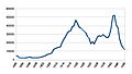
Ticket sales at Morrinsville railway station from 1885 to 1950.
-
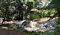
A waterfall on the Waitakaruru Stream, next to the Morrinsville River Walk.


