Matamata-Piako District facts for kids
Quick facts for kids
Matamata-Piako District
|
|
|---|---|
|
Territorial authority district
|
|

Te Aroha
|
|
 |
|
| Country | New Zealand |
| Region | Waikato |
| Wards | Matamata Morrinsville Te Aroha |
| Seat | Te Aroha |
| Area | |
| • Land | 1,755.35 km2 (677.74 sq mi) |
| Population
(June 2023)
|
|
| • Total | 37,700 |
| Time zone | UTC+12 (NZST) |
| • Summer (DST) | UTC+13 (NZDT) |
| Postcode(s) |
Map of postcodes
|
| Website | Matamata-Piako District Council |
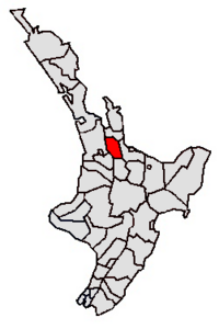
The Matamata-Piako District is a special area in the Waikato region of New Zealand. It's like a local government area, meaning it has its own council that helps run things for the people living there. This district is located to the east of the big city of Hamilton.
Contents
Exploring the Geography
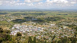
This district covers a wide area, including the southern part of the Hauraki Plains and a lot of the Thames Valley. To the east, you'll find the Kaimai Range mountains. Two important rivers, the Piako and the Waihou, flow right through the district.
The main towns in the district are Matamata, Morrinsville, and Te Aroha. The main office for the district's council is in Te Aroha. The biggest industry here is dairy farming, which means raising cows for milk. It's also famous for breeding and training Thoroughbred horses, which are used for racing. Other smaller communities in the district include Mangateparu and Waitoa.
Towns and Communities
The Matamata-Piako District is made up of many different towns, villages, and communities. They are grouped into three main areas called Wards:
|
|
Understanding the Population
The Matamata-Piako District covers about 1,755 square kilometers. As of 2018, around 34,404 people lived here. This means there were about 19.6 people for every square kilometer. In 2023, the population grew to 37,098 people.
A census is like a big survey that counts everyone living in a country. The 2023 census showed that the population in Matamata-Piako District increased by 2,694 people since 2018. The average age of people living here was 40.8 years old. About 19.7% of the people were under 15 years old.
People in the district come from many different backgrounds. The census found that:
- 83.3% were of European descent (also called Pākehā).
- 18.6% were Māori.
- 2.6% were Pasifika (from Pacific Islands).
- 6.9% were Asian.
- A small number were from the Middle East, Latin America, or Africa.
- 1.0% identified with other ethnic groups.
Some people identify with more than one ethnicity.
About 14.4% of the people living in Matamata-Piako District were born outside of New Zealand. This is lower than the national average for New Zealand, which is 27.1%.
When it comes to beliefs, the census showed that:
- 51.4% of people said they had no religion.
- 35.8% were Christian.
- A small number followed Māori religious beliefs, Hindu, Muslim, or Buddhist faiths.
Population by Ward
Here's a look at the population in each of the three main wards:
| Name | Area (km2) | Population | Density (per km2) | Households | Median age |
|---|---|---|---|---|---|
| Morrinsville Ward | 573.00 | 12,501 | 21.82 | 4,608 | 38.6 years |
| Te Aroha Ward | 517.10 | 8,268 | 15.99 | 3,126 | 43.3 years |
| Matamata Ward | 665.24 | 13,635 | 20.50 | 5,142 | 41.4 years |
| New Zealand | 37.4 years |
Sister Cities
Matamata-Piako District has a special friendship with another city, called a "sister city" or "twin city." This helps build connections and understanding between different places.
 | Calvin Brent |
 | Walter T. Bailey |
 | Martha Cassell Thompson |
 | Alberta Jeannette Cassell |

