
Ballina, New South Wales facts for kids
Quick facts for kids BallinaNew South Wales |
|||||||||
|---|---|---|---|---|---|---|---|---|---|

Clockwise from top left: The Big Prawn, Ballina Court House, Ballina Manor, Shelly Beach, River Street Mall.
|
|||||||||

Ballina
Location in New South Wales
|
|||||||||
| Population | 46,190 (2021) | ||||||||
| Established | 1840s | ||||||||
| Postcode(s) | 2478 | ||||||||
| Elevation | 1.3 m (4 ft) | ||||||||
| Location | |||||||||
| LGA(s) | Ballina Shire | ||||||||
| State electorate(s) | Ballina | ||||||||
| Federal Division(s) | Richmond | ||||||||
|
|||||||||
Ballina (/bælɪnə/) is a fun town in the Northern Rivers area of New South Wales, Australia. It's the main town for the Ballina Shire local government area. Ballina is about 740 kilometres (460 miles) north of Sydney and 185 kilometres (115 miles) south of Brisbane. In 2021, about 46,190 people lived in the Ballina urban area.
The town is located on the Richmond River. It's also a popular starting point for visiting nearby Byron Bay.
Contents
History of Ballina
Ballina is on the traditional land of the Bundjalung people. They are the original inhabitants and have lived here for at least 6,000 years.
The name Ballina might come from the Bundjalung language. Some say Bullina or Bul-loona was a clan name. In their language, bullinah could mean "place of many oysters." This name might have reminded Irish settlers of a town in Ireland called Ballina.
Another idea is that the name comes directly from the Irish word Béal an Átha. This means "mouth of the ford." You can find this name in several places in Ireland.
Early European Settlement
Ballina was started in the 1840s on the north side of the Richmond River. This is about 20 kilometres (12 miles) south of Cape Byron. Cape Byron is the most easterly point in Australia.
In 1828, a ship called HMS Rainbow sailed into the Richmond River. Later, settlers came overland from the Clarence River. In 1842, more settlers arrived on a ship named Sally. They set up a community where East Ballina is today, near Shaws Bay.
A lighthouse, called Richmond River Light, was built in Ballina in 1866. This lighthouse helped ships come into the port. The first lighthouse was temporary. A new, permanent one was designed by James Barnet and lit in 1880. It is still working today!
Famous Landings
Ballina is known for some special landings. In 1928, Charles Kingsford Smith's plane, the Southern Cross, flew over Ballina. This was after its amazing flight across the Pacific Ocean. Ballina used to have a festival to celebrate this event. There's even a school in East Ballina named "Southern Cross."
In 1973, the Las Balsas rafts arrived in Ballina. Fishing boats towed them in after their long journey from Ecuador. One of these rafts is now kept at the Ballina Naval and Maritime Museum. The rafts were supposed to land in Mooloolaba in Queensland. But ocean currents pushed them off course. Their journey was almost twice as long as the famous Kon-Tiki expedition. It showed that people could have traveled across the Pacific a long time ago.
What to See and Do
Ballina is a coastal town. It's connected to the Pacific Highway. The highway now goes around the town.
The Richmond River was very important for transport in the past. Today, the river and its smaller waterways are full of marine life. They are great for fishing and water sports.
Ballina has several beautiful beaches. These include Shelly, Lighthouse, Angels, Flat Rock, and Sharpes beaches.
You can also visit historical places like the Ballina Manor. The Ballina Naval and Maritime Museum is also a great spot. But its most famous landmark is definitely the "Big Prawn"!
The Big Prawn


Ballina is home to the world's largest prawn model! It's made of concrete and fibreglass. In 2009, the local council thought about tearing it down. But they never did.
Later, Bunnings Warehouse bought the land. They fixed up the Prawn as part of their new store. Now, the Big Prawn sits proudly next to the entrance of the Bunnings car park.
From 2013 to 2017, Ballina had a "Prawn Festival." It featured music and fun activities.
In 2018, something funny happened. Google Maps' software blurred out the Prawn's "face." People on Reddit Australia noticed it first. Then, The Sydney Morning Herald reported on it.
There's even a friendly "Prawn War" going on! There's another Big Prawn in Exmouth, Western Australia. Ballina's Prawn is much bigger. But people in Exmouth say theirs looks more like a real prawn.
Climate
Ballina has a warm, humid climate. It's typical for Australia's eastern coast. Summers are hot, humid, and rainy. About 40% of the town's rain falls from December to March. March is usually the wettest month.
Ballina gets a lot of rain each year, about 1764.7 millimetres (69.5 inches). This is because it's on the coast. It's also close to Cape Byron, which gets a lot of moisture from the ocean.
The hottest temperature ever recorded in Ballina was 42.0°C (107.6°F). The coldest was -2.0°C (28.4°F).
| Climate data for Ballina Byron Gateway Airport (28º50'S, 153º34'E, 1 AMSL) (1992–2024 normals and extremes) | |||||||||||||
|---|---|---|---|---|---|---|---|---|---|---|---|---|---|
| Month | Jan | Feb | Mar | Apr | May | Jun | Jul | Aug | Sep | Oct | Nov | Dec | Year |
| Record high °C (°F) | 42.0 (107.6) |
41.0 (105.8) |
36.3 (97.3) |
32.6 (90.7) |
30.0 (86.0) |
28.0 (82.4) |
28.7 (83.7) |
36.7 (98.1) |
38.2 (100.8) |
37.0 (98.6) |
38.1 (100.6) |
40.0 (104.0) |
42.0 (107.6) |
| Mean daily maximum °C (°F) | 28.4 (83.1) |
28.1 (82.6) |
27.1 (80.8) |
25.0 (77.0) |
22.5 (72.5) |
20.4 (68.7) |
20.1 (68.2) |
21.4 (70.5) |
23.6 (74.5) |
24.9 (76.8) |
26.3 (79.3) |
27.6 (81.7) |
24.6 (76.3) |
| Mean daily minimum °C (°F) | 19.8 (67.6) |
19.7 (67.5) |
18.6 (65.5) |
15.4 (59.7) |
12.2 (54.0) |
9.9 (49.8) |
8.8 (47.8) |
8.9 (48.0) |
11.6 (52.9) |
14.2 (57.6) |
16.5 (61.7) |
18.4 (65.1) |
14.5 (58.1) |
| Record low °C (°F) | 12.2 (54.0) |
13.2 (55.8) |
11.0 (51.8) |
5.9 (42.6) |
2.0 (35.6) |
−2.0 (28.4) |
0.0 (32.0) |
1.0 (33.8) |
0.4 (32.7) |
4.2 (39.6) |
7.0 (44.6) |
9.3 (48.7) |
−2.0 (28.4) |
| Average rainfall mm (inches) | 170.6 (6.72) |
223.6 (8.80) |
225.4 (8.87) |
182.2 (7.17) |
158.0 (6.22) |
188.8 (7.43) |
107.4 (4.23) |
75.3 (2.96) |
68.1 (2.68) |
107.1 (4.22) |
117.5 (4.63) |
144.0 (5.67) |
1,764.7 (69.48) |
| Average rainy days (≥ 1.0 mm) | 10.5 | 12.4 | 14.5 | 12.2 | 11.6 | 10.2 | 8.6 | 6.8 | 6.1 | 8.9 | 9.1 | 9.7 | 120.6 |
| Average afternoon relative humidity (%) | 67 | 68 | 67 | 65 | 64 | 62 | 59 | 55 | 59 | 62 | 65 | 64 | 63 |
| Average dew point °C (°F) | 19.7 (67.5) |
19.9 (67.8) |
18.5 (65.3) |
16.1 (61.0) |
13.4 (56.1) |
11.0 (51.8) |
9.9 (49.8) |
9.9 (49.8) |
12.5 (54.5) |
14.7 (58.5) |
16.8 (62.2) |
18.3 (64.9) |
15.1 (59.1) |
| Source: Bureau of Meteorology (1992-2024 normals and extremes) | |||||||||||||
Media and News
The Northern Rivers Echo is a free weekly newspaper. It shares news with Ballina and nearby towns. The Northern Star is another local newspaper. It covers a wide area around Ballina.
Ballina also gets TV channels like SBS and ABC. You can also watch regional channels like Seven, Nine, and WIN Television’s 10 Northern NSW.
For radio, there's Triple Z (Hit Music) and 2LM 900 AM. There's also a community radio station called Paradise FM 101.9. Other stations include Triple J 96.1 FM and ABC North Coast 94.5 FM.
Schools and Services
Ballina has several primary schools:
- Ballina Public School
- Emmanuel Anglican College
- Holy Family Catholic Primary School
- Richmond Christian College
- St. Francis Xavier Primary School
- Southern Cross School
There are also four high schools:
- Emmanuel Anglican College
- Richmond Christian College
- Ballina Coast High School
- Xavier Catholic College
The town has a hospital, the Ballina District Hospital. It's a local community hospital. There are also places for aged care.
Getting Around Ballina
Ballina Bypass
A special road project called the Ballina bypass was built. It made 12.4 kilometres (7.7 miles) of dual carriageway road. This road helps traffic flow better around Ballina. It connects the Bruxner and Pacific highways.
Work on the bypass started in 2008. The main part opened in 2011. The whole project was finished in mid-2012. This bypass helps separate highway traffic from local town traffic.
Ballina Byron Gateway Airport
The Ballina Byron Gateway Airport is the main airport for the area. It's about 5 kilometres (3 miles) from the centre of Ballina. You can fly from here to Newcastle, Melbourne, and Sydney. Airlines like FlyPelican, Jetstar, Rex Airlines, and Virgin Australia use this airport.
The airport is a short drive to Byron Bay and Lismore. In 2005, it was renamed the Ballina Byron Gateway Airport. This was done to attract more visitors to the area. In 2024, the airport got a big upgrade to help even more flights.
Sports in Ballina
Ballina has many sports clubs:
- The Ballina Seagulls is the local rugby league team. They play in the Northern Rivers Regional Rugby League.
- The Ballina Seahorses is the rugby union club. They compete in the Far North Coast Rugby zone.
- The Ballina Bombers is the Australian rules football club. They play in the Queensland Football Association.
- There are also cricket clubs like the Ballina Bears and Tintenbar-East Ballina. They play in local and regional competitions.
Famous People from Ballina
- Mitchell Aubusson, a rugby league player for the Sydney Roosters
- Simon Baker, an actor
- Dustin Clare, an actor
- Nathan Crosswell, a basketball player
- Declan Curran, a rugby union player
- Dustin Dollin, a professional skateboarder
- George Martin, a former mayor of Ballina
- Hunter Poon, a cricketer
- Kerry Saxby-Junna, a famous race walker who competed with the Ballina Athletic Club
Twin Cities
Ballina has "twin city" relationships with:
- Ballina, County Mayo, Ireland
- Matamata-Piako District, Waikato, New Zealand
Gallery
-

Boats on the Richmond River at Ballina
-
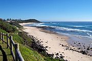
Ballina beaches
-
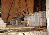
The Las Balsa raft at the Ballina Naval and Maritime Museum
-
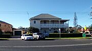
Riversleigh, Ballina
-
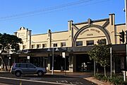
Wigmore Arcade
-
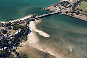
Missingham Bridge crossing North Creek from Ballina to East Ballina.
-
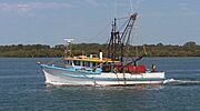
Richmond River Prawn Trawler


