
Cape Byron facts for kids
Quick facts for kids Cape Byron |
|
|---|---|
 |
|
| Location | Byron Bay, NSW |
| Coordinates | 28°37′58″S 153°38′20″E / 28.632778°S 153.638889°E |


Cape Byron is the most eastern point of mainland Australia. It is found in the state of New South Wales. This cape is about 3 kilometers (2 miles) east of the town of Byron Bay. It sticks out into the Pacific Ocean. A famous lighthouse stands here. It's a great spot for hiking and watching whales. There are also two national parks and a marine park nearby.
Contents
History of Cape Byron
The cape was named by a British explorer named Captain James Cook. He sailed past this area on May 15, 1770. Captain Cook named it to honor another British explorer, John Byron. John Byron sailed all the way around the world between 1764 and 1766. He did this on a ship called HMS Dolphin. Today, Cape Byron is part of the Cape Byron State Conservation Area.
Cape Byron Lighthouse
The Cape Byron Lighthouse was built in 1901. It was one of the last big lighthouses from the 1800s. The National Parks and Wildlife Service (NPWS) now manages it. The lighthouse is made from concrete blocks. It stands right on the most eastern tip of mainland Australia.
-
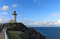
The Cape Byron Lighthouse
-
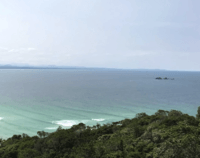
The northern coastline of Cape Byron from the lighthouse cafe


Cape Byron Walking Track
The Cape Byron walking track is a popular path. It goes through the Cape Byron State Conservation Area. This walking track is a loop, about 3.7 kilometers (2.3 miles) long. You can start the walk from different spots. There is parking available at Captain Cook Lookout, Palm Valley, Wategos Beach, and near the Lighthouse.
Cape Byron Marine Park

Cape Byron is part of a large area called the Cape Byron Marine Park. This park covers 22,000 hectares (about 54,000 acres). It was created in November 2002. The area is well-known for its amazing wildlife. The whale watching industry is very important to the local economy here.
The Cape Byron Marine Park is a special kind of park. It has areas where fishing and collecting are not allowed. But it also has general-use areas where people can fish for fun or for business. The park stretches from the Brunswick River to Lennox Head. It goes from the coast out to three nautical miles into the ocean. It also includes the tidal waters of the Brunswick River, Belongil, and Tallow creeks. You can often see migrating whales swimming past the Cape.
See also
 In Spanish: Cabo Byron para niños
