Kaimai Range facts for kids
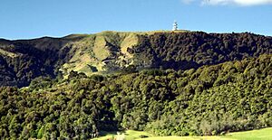
The Kaimai Range is a cool mountain range in New Zealand's North Island. It's like a natural wall that separates two regions: Waikato on the west side and the Bay of Plenty on the east. To the north, it connects with the Coromandel Range, and to the south, with the Mamaku Ranges.
The tallest point is Mount Te Aroha, which is 952 meters high. The town of Te Aroha is right at the base of this mountain. The Kaimai Range has rough land, and only two main roads cross it. One is State Highway 2, which goes through the Karangahake Gorge in the north. The other is State Highway 29, connecting Tauranga to Hamilton.
The name Kaimāī means "eat fermented food" in Māori. This name comes from local Māori stories. The name Te Aroha means "the love" in Māori. It comes from a legend about the sun god and moon goddess. They could never see each other because of where their planets were. One day, the moon goddess came to Earth to see the sun god. She knew it was risky and turned to stone when daylight came. This was her ultimate act of love. On the Kaimai Range, you can see a rock that looks like a woman from far away. It's known as the rock of Hinemoa.
You can find some great walking tracks in the Kaimai Ranges. The Hendersons Tramline loop track follows old routes used to move logs from the forest. This walk goes through both forests and open areas. There's even a side path that leads to a waterfall and a big swimming hole. Another track, Thomsons track, is for four-wheel drive vehicles. It takes you from the foothills to the top of the range, where there's another large swimming hole.
Contents
How the Kaimai Range Formed
The Kaimai Range was created by a fault line. This fault caused rocks from old volcanoes, mostly andesite, to be pushed upwards. This process started over a million years ago, but the fault hasn't been active for about 140,000 years.
Long ago, before Europeans arrived, the area was covered in thick forests. Many native trees grew here, like kauri, mataī, and tawa. It was also home to many native birds, such as kererū, tui, kākā, and kiwi.
Kaimai Railway Tunnel
The Kaimai Railway Tunnel is a very long tunnel that goes under the Kaimai Range. It's almost nine kilometers long, making it the longest tunnel in New Zealand! Building the tunnel started in 1969 from both sides of the range. The two sides met in 1976, and the tunnel officially opened on September 12, 1978.
Because of this tunnel, a special train service called the Kaimai Express ran between Auckland and Tauranga from 1991 to 2001. In 2010, a peak directly above the tunnel was named Stokes Peak. This was to honor a geographer named Evelyn Stokes.
Flight 441 Accident
On July 3, 1963, a DC-3 plane called Skyliner ZK-AYZ Hastings crashed into the Kaimai Range. This plane was flying from Whenuapai Airport in Auckland to Tauranga. Sadly, all 23 people on board died. This was the worst air accident on mainland New Zealand at that time.
Communications Facilities
The Kaimai Range is also important for communications. Near the top of the range, close to the Hamilton–Tauranga highway, there's a microwave communications facility. This facility helps send radio signals across the country. Today, it has cell phone towers and other radio equipment.
Airways New Zealand also has a special radar system on Te Weraiti, a peak on the Kaimai Range. This radar helps air traffic controllers guide planes that have transponders in the area.
See also
 In Spanish: Cordillera Kaimai para niños
 | Anna J. Cooper |
 | Mary McLeod Bethune |
 | Lillie Mae Bradford |


