Coromandel Range facts for kids
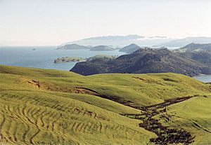
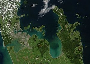
The Coromandel Range is a chain of tall, rocky hills. It runs along the Coromandel Peninsula in the North Island of New Zealand. This range is about 60 kilometers (37 miles) east of the city of Auckland. It stretches for about 85 kilometers (53 miles) from north to south.
Contents
What is the Coromandel Range?
The Coromandel Range is a long line of hills. It forms the backbone of the Coromandel Peninsula. The highest point is Mount Moehau. It stands 892 meters (2,927 feet) tall. You can find it at the northern end of the peninsula. Many other peaks in the range are taller than 600 meters (1,968 feet).
Forests and Wildlife
A long time ago, before Europeans arrived, the southern Coromandel Range was covered in thick forests. These forests had huge trees like kauri, mataī, and tawa. Many native New Zealand birds lived there. These included the large kererū (New Zealand pigeon), the singing tui, the clever kākā parrot, and the shy kiwi.
Stone Tools and History
The local Hauraki Māori people used rocks from the Coromandel Range. They used a type of rock called Greywacke. This rock was perfect for making many kinds of stone tools. These tools were important for daily life and survival.
Where Does the Range Go?
The Coromandel Range is part of a longer chain of hills. This chain runs through the northern part of New Zealand's North Island. South of the Coromandel Range, there is a winding place called the Karangahake Gorge. After the gorge, the hills continue as the Kaimai Range.
Connection to Great Barrier Island
The large Great Barrier Island is also part of this hill chain. It sits at the entrance to the Hauraki Gulf. This island is directly north of the Coromandel Peninsula. You can think of it as a natural extension of the Coromandel Range.
 | Calvin Brent |
 | Walter T. Bailey |
 | Martha Cassell Thompson |
 | Alberta Jeannette Cassell |


