
Matamata facts for kids
Quick facts for kids
Matamata
|
|
|---|---|

Matamata information centre
|
|

Matamata
Location in New Zealand
|
|
| Country | New Zealand |
| Region | Waikato |
| Territorial authority | Matamata-Piako District |
| Ward | Matamata Ward |
| Electorates |
|
| Area | |
| • Total | 9.59 km2 (3.70 sq mi) |
| Elevation | 63 m (207 ft) |
| Population
(June 2023)
|
|
| • Total | 9,130 |
| • Density | 952.0/km2 (2,465.8/sq mi) |
| Time zone | UTC+12 (NZST) |
| • Summer (DST) | UTC+13 (NZDT) |
| Postcode |
3400
|
| Area code(s) | 07 |
Matamata is a town in the Waikato region of New Zealand. It's located near the Kaimai Ranges. This area is well-known for its successful farms, especially for breeding and training Thoroughbred horses. Matamata is part of the Matamata-Piako District, which also includes nearby towns like Morrinsville and Te Aroha. The town has a population of about 9,130 people.
One of the most famous things about Matamata is that a farm nearby was used as the location for the Hobbiton Movie Set. This is where parts of Peter Jackson's The Lord of the Rings movies were filmed. The New Zealand government decided to keep the Hobbit holes as a tourist attraction. You can visit them and see the farm from inside. Later, parts of Hobbiton were closed to get ready for filming The Hobbit movies.
Contents
About Matamata's Population
Matamata covers an area of about 9.59 square kilometers. As of June 2023, the town has an estimated population of 9,130 people. This means there are about 952 people living in each square kilometer.
| Historical population | ||
|---|---|---|
| Year | Pop. | ±% p.a. |
| 2006 | 6,297 | — |
| 2013 | 7,086 | +1.70% |
| 2018 | 7,806 | +1.95% |


The town's population has grown a lot over the years. For example, between the 2006 and 2018 censuses, the population increased by 24%. In 2018, there were more females than males living in Matamata. About 17.6% of the people were under 15 years old, and 28% were 65 or older.
Most people in Matamata are of European background (Pākehā), but there's also a good number of Māori people. Smaller groups include Pacific peoples and Asian people. About 16.6% of the people living in Matamata were born outside New Zealand.
When it comes to religion, nearly half of the people in Matamata said they had no religion. Many others are Christian. Some people follow Māori religious beliefs, Hindu, Muslim, or Buddhist faiths.
Matamata's History
In the early 1800s, the land around Matamata belonged to Māori tribes called Ngāti Hinerangi and Ngāti Hauā. The original Matamata pā (a fortified Māori village) was actually located a few kilometers north, near where the town of Waharoa is today.
The first European to visit the Matamata area was a trader named Phillip Tapsell around 1830. Later, in 1835, a missionary named Reverend Alfred Nesbit Brown opened a mission near the Matamata Pā. However, it closed soon after due to fighting between different Māori tribes.
In 1865, a man named Josiah Firth leased a large area of land from the Ngāti Hauā leader Wiremu Tamihana. Firth named the area after the pā. He built a road to Cambridge and made the Waihou River easier for small boats to travel on.
Over time, Firth's land was taken over by the government. By 1904, it was divided into smaller dairy farms. This was possible because of new refrigeration technology, which helped farmers store and transport milk products. Matamata officially became a town district in 1917 and a borough in 1935. In 1989, it became part of the Matamata-Piako District.
The Railway Station

Matamata got its own railway station on March 8, 1886. It was part of the Kinleith Branch railway line. The station helped the town grow by making it easier to transport goods and people. Early on, the station had a goods shed, a coal shed, and houses for railway staff. It also had a water tank and a windpump.
Over the years, the station was improved with a new platform, a telephone, and a verandah. In 1919, part of an old station building from Drury was even moved to Matamata to be used as a luggage room. The station was very busy in the 1920s, selling thousands of tickets and helping to export many sheep and pigs.
In 1965, a brand new station building was opened. However, Matamata closed to regular passenger trains in 1968. It did reopen for a special train called the Geyserland Express from 1991 to 2001.
Today, the old station building is no longer used for trains. Since 2002, it has been a community center called Railside by the Green. Sometimes, special train trips still use the platform.
Sports in Matamata
Matamata is home to the Matamata Swifts soccer team. They play in a league called the Lotto Sport Italia NRFL Division 1A.
Schools in Matamata
Matamata has several schools for different age groups:
- Matamata College is the main high school for boys and girls. It has about 781 students.
- Matamata Intermediate is for students in the middle years.
- There are two public primary schools: Matamata Primary School and Firth School. Firth School's motto, E Tipu E Rea, means Grow and Flourish.
- Matamata Christian School is a Christian primary school.
- St Joseph's Catholic School is a Catholic primary school.
-
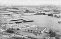
Matamata College from above in the 1940s.
-
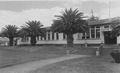
The front of Matamata College in the 1950s.
-
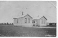
Matamata Public School around 1909.
-
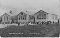
Matamata Public School around 1919.
.jpg)
Famous People from Matamata
Many notable people have connections to Matamata, including:
- Kristine Crabb
- Shane Dye
- Claudia Pond Eyley
- Casey Kopua
- Michael Moroney
- Dave O'Sullivan
- Paul O'Sullivan
- Lance O'Sullivan
- Tim Mikkelson
- Hon Mike Rann
- Dame Patsy Reddy
- Tom Sainsbury
- Matthew Stanley
- Dame Catherine Tizard
- Kyle Wealleans
Nearby Towns
Some smaller towns close to Matamata are:
- Hinuera
- Peria
- Turanga-O-Moana
- Te Poi
- Waharoa
- Walton, New Zealand
- Wardville, New Zealand
Climate
Matamata has a generally mild climate. Summers are usually warm, and winters are cool but not too cold. The area receives a good amount of rain throughout the year, which helps the farming land stay green and fertile.
