Waikato District facts for kids
Quick facts for kids
Waikato District
|
|
|---|---|
|
Territorial authority district
|
|
 |
|
 |
|
| Country | New Zealand |
| Region | Waikato |
| Wards | Awaroa ki Tuakau, Eureka, Huntly, Hukanui Waerenga, Newcastle, Ngāruawāhia, Onewhero-Te Akau, Tamahere, Raglan, Whangamarino |
| Seat | Ngāruawāhia |
| Area | |
| • Land | 4,403.81 km2 (1,700.32 sq mi) |
| Population
(June 2023)
|
|
| • Total | 90,100 |
| Time zone | UTC+12 (NZST) |
| • Summer (DST) | UTC+13 (NZDT) |
| Postcode(s) |
Map of postcodes
|
| Website | Waikato District Council |
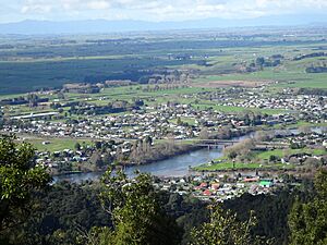
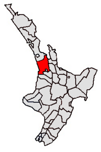
Waikato District is a local government area in the northern part of the Waikato region, located on the North Island of New Zealand. It is managed by the Waikato District Council, with its main office in Ngāruawāhia.
The district is mostly found to the north and west of the city of Hamilton. It includes a large part of the northern Waikato Plains and the Hakarimata Range. In the northern area, you'll find swampy floodplains of the Waikato River and several small lakes. The biggest of these lakes is Lake Waikare.
Besides Ngāruawāhia, other important towns in the district include Huntly, Raglan, and Te Kauwhata. The main jobs and businesses in the district are dairy farming, growing trees for forestry, and coal mining. There's a big power station that uses coal in Huntly, called the Huntly Power Station. Te Kauwhata is also known for its important wine region.
Contents
People and Population
The Waikato District has grown a lot over the years. In 2006, about 43,959 people lived here. Some of the larger towns at that time were Huntly, Ngāruawāhia, Raglan, and Te Kauwhata.
In 2010, the district became larger when it took in a part of the nearby Franklin District. This happened when the Auckland Council was created. This change increased the district's size to about 4,405 square kilometers. It also added new towns like Tuakau and Pōkeno.
By 2023, the population of Waikato District had reached 85,968 people. This was a big increase of 13.7% since the 2018 census. The average age of people living here was 38.0 years old.
Who Lives Here?
People in Waikato District come from many different backgrounds. Based on the 2023 census, the main ethnic groups are:
- European/Pākehā: 73.6%
- Māori: 26.9%
- Pasifika: 5.5%
- Asian: 9.1%
- Middle Eastern, Latin American and African New Zealanders: 1.1%
- Other: 1.3%
Many people in the district were born in New Zealand, but about 15.9% were born overseas.
Beliefs and Jobs
When asked about their religious beliefs, many people (53.9%) said they had no religion. Others identified as Christian (33.2%), or had Māori religious beliefs (1.8%). Smaller groups followed Hinduism, Islam, or Buddhism.
For those aged 15 and older, about 18.3% had a university degree or higher. The average income in the district was $34,700. Most people (53.2%) worked full-time, while 14.9% worked part-time.
| Ethnicity | Population |
|---|---|
| New Zealand European |
63,252
|
| Māori |
23,088
|
| Pasifika |
4,704
|
| Asian |
7,821
|
| MELAA |
936
|
| Other |
1,101
|
| Historical population | ||
|---|---|---|
| Year | Pop. | ±% p.a. |
| 2006 | 57,588 | — |
| 2013 | 63,378 | +1.38% |
| 2018 | 75,618 | +3.59% |
| 2023 | 85,968 | +2.60% |
History of Local Government
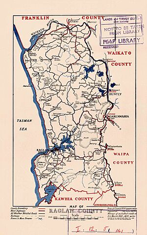
The Waikato District Council was formed in 1989. This happened when most of the old Waikato County Council joined with the towns of Huntly and Ngāruawāhia. Most of the Raglan County Council and a small part of Waipa County Council also became part of it.
Before this, County Councils had been around for over a hundred years, starting in 1876. Even before that, there were Highways Boards, which began in 1866. People used to complain that the Auckland Province spent too much money in Auckland itself, and not enough in the country areas. For example, in 1867, settlers from Raglan asked the government to create more local councils. They pointed out that only a tiny amount of a large loan was spent in all the country districts.
Early Highways Boards
In 1862, the Auckland Province created a law for Highways Districts. This allowed local areas to set up boards of trustees. These trustees were elected by landowners. People in these districts had to pay a tax on their land. The Province would then give an equal amount of money to help with roads.
The Whaingaroa Highway District, the first in what would become Raglan County, was announced in August 1866. A meeting was held in Raglan in October 1866 to choose five trustees. The first chairman and three other trustees quit because they couldn't collect taxes from landowners who weren't there. Also, the Province didn't pay its share.
Later, the Raglan Town Board was formed in 1868. The Karioi Board was created in 1870. By 1871, many board chairmen met to ask the government for more help. From 1872 onwards, the government started giving more money than what was collected in local taxes. Today, government funding for roads often matches the money collected from local taxes.
Raglan County Council
The Counties Act of 1876 led to the creation of the first county councils. Raglan County Council had its first meeting in Raglan on January 9, 1877.
Raglan County was divided into five areas called "ridings." These were Karioi, Pirongia, Te Akau, Onewhero, and Whangape. Karioi and Pirongia had two councillors each, while the others had one. At the first meeting, only three of the ridings were represented. Many areas were not very populated, so it was hard for people to get together and choose councillors.
As more people moved in, the original five ridings were split into smaller ones. For example, Karamu was formed from Pirongia in 1889. Whaingaroa came from Karioi in 1902. Pukekawa was created from Onewhero, and Port Waikato from Te Akau in 1911. Pukemiro came from Whangape in 1913, and Waingaro from Te Akau in 1920.
In 1923, Raglan County covered about 2,419 square kilometers. It had a population of 4,912 people. There were many miles of gravel roads, mud roads, and even just tracks.
Some parts of Raglan County were moved to other councils over time. For example, a coal-mining area of Huntly West became part of Huntly Borough in 1944. In 1954, a Raglan Town Committee was formed. Later, under the Local Government Act 1974, Raglan and Rotowaro became "community towns" with their own elected councils.
The county council relied on money from the government until 1887. After that, government cuts meant they had to start collecting local taxes. From 1889 to 1902, the smaller Highways Boards gradually joined the County Council. Until 1943, each riding paid for its own roads and bridges, with some extra money from the main council.
When the Waikato District Council was formed in 1989, the northern part of Raglan County joined the Franklin District. The rest became part of the new Waikato District.
Council Offices
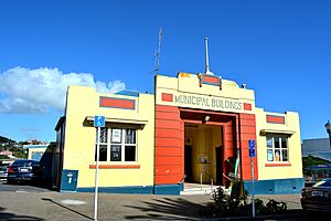
Raglan also had a Town Board at different times. From 1928, after a fire, the Raglan Town Board had its offices in the Municipal Buildings in Raglan. This lasted until the Board joined with the County Council again.
From 1876 to 1888, Raglan County Council meetings were held in Raglan. However, Raglan was not central for everyone in the county. So, meetings then took turns between Raglan and Whatawhata. On May 15, 1901, Raglan County held its first meeting in its new offices in Ngāruawāhia. They still had at least one meeting a year in Raglan.
In 1908, the council decided to sell the old office and build bigger ones in Ngāruawāhia. These new offices opened in 1909. On May 27, 1961, a new, larger brick building was opened. The old office was sold in 1961 and later burned down in 1971.
Community Boards
The Waikato District has five community boards. These boards help local communities have a say in how their areas are run. They cover:
- Huntly
- Ngāruawāhia
- Raglan (these three were formed in 1989)
- Taupiri (added in 1992)
- Onewhero-Tuakau (added in 2010, covering part of the old Franklin District)
Community Committees
The District also has five Community Committees. These are for the towns of Meremere, Te Kauwhata, and the Tamahere ward. There is also the North East Waikato Committee, which covers Mangatawhiri, Mangatangi, and Maramarua.
In 2019, the Council created "Community BluePrints." These plans help capture what local communities hope for their future. They also guide how the district will develop.
 | Precious Adams |
 | Lauren Anderson |
 | Janet Collins |


